TopoQuest Logo
Do you find TopoQuest useful?
Help keep TopoQuest running and adding new maps/features by donating!
Bitcoin:  19c7KJd3qBynnjoSw5npx9KScwjBe4ifkT
Litecoin:  LXs6TkuXGGXo1vDsWCkWVdjQX94eUKd6ui
Home View Maps Find Maps Find Places Resources & Links


Sycamore, Florida Topographic Map

USGS Map Title: Sycamore, FL
USGS Map MRC: 30084E7
DRG (GeoTIFF) Download: o30084e7.tif


Neighboring USGS Topographic Map Quads:


  Sneads, FL  
30084F8
 

  Chattahoochee, FL  
30084F7
 

  Mount Pleasant, FL  
30084F6
 

  Rock Bluff, FL  
30084E8
 

  Sycamore, FL  
30084E7
 

  Gretna, FL  
30084E6
 

  Bristol, FL  
30084D8
 

  Hosford, FL  
30084D7
 

  Bloxham, FL  
30084D6


Map MRC Location:

N31°
W85°
N31°
W84°
H8 H7 H6 H5 H4 H3 H2 H1
G8 G7 G6 G5 G4 G3 G2 G1
F8 F7 F6 F5 F4 F3 F2 F1
E8 E7 E6 E5 E4 E3 E2 E1
D8 D7 D6 D5 D4 D3 D2 D1
C8 C7 C6 C5 C4 C3 C2 C1
B8 B7 B6 B5 B4 B3 B2 B1
A8 A7 A6 A5 A4 A3 A2 A1
N30°
W85°
N30°
W84°

Sycamore, FL USGS 1:24K Topographic Map Preview:
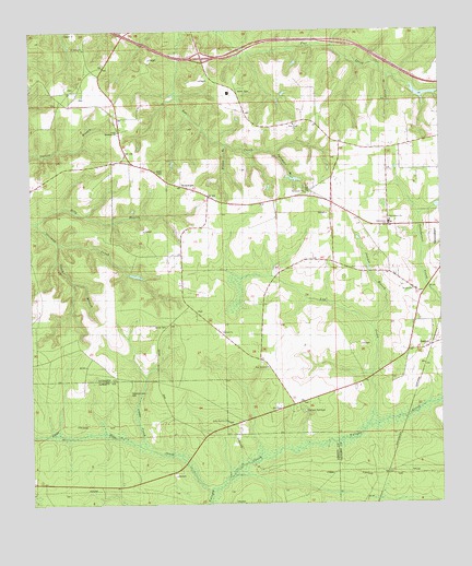
Sycamore, FL USGS Topographic Map
Click on map above to begin viewing in our Map Viewer.

This topographic map contains these locations and features:
Feature Name Type Latitude Longitude GNIS ID View Map
Billy BranchStreamN30.5744°W84.8735°278775View Map
Camp CreekStreamN30.5152°W84.8402°279888View Map
Clark BranchStreamN30.5694°W84.8666°280493View Map
Flat Creek AirportAirportN30.6043°W84.7899°309465View Map
Flat Creek ChurchChurchN30.6005°W84.7941°282559View Map
Gause CemeteryCemeteryN30.5474°W84.8335°282994View Map
Greensboro ChurchChurchN30.5516°W84.8246°283425View Map
Greensboro DivisionCivilN30.5439°W84.7678°1935783View Map
Greensboro SchoolSchoolN30.5741°W84.7652°300192View Map
H M Spooner PondLakeN30.5788°W84.7505°298135View Map
Hawkins Lane ChurchChurchN30.5296°W84.8455°283826View Map
Jacob BranchStreamN30.6132°W84.7652°284705View Map
JuniperPopulated PlaceN30.5427°W84.7532°295383View Map
Juniper BranchStreamN30.5210°W84.7724°284986View Map
Little Sycamore ChurchChurchN30.5985°W84.8480°285834View Map
Mule CreekStreamN30.5044°W84.8191°287444View Map
Pine Grove CemeteryCemeteryN30.5374°W84.8046°300193View Map
Pine Grove ChurchChurchN30.5360°W84.8030°288848View Map
Pitt Land Slide PondLakeN30.6164°W84.7939°298134View Map
Pitts PointBasinN30.6094°W84.7605°289011View Map
Poley Branch CemeteryCemeteryN30.5219°W84.8155°300194View Map
Poley Branch ChurchChurchN30.5221°W84.8155°289144View Map
Saint James ChurchChurchN30.6088°W84.8627°290193View Map
Saint James ChurchChurchN30.6207°W84.8585°290194View Map
Smith CemeteryCemeteryN30.6094°W84.8113°291249View Map
SycamorePopulated PlaceN30.5841°W84.8288°294942View Map
Sycamore BranchStreamN30.5927°W84.7999°291976View Map
Sycamore ChurchChurchN30.5821°W84.7908°291977View Map
Sycamore Volunteer Fire DepartmentBuildingN30.5908°W84.8467°2644366View Map
Wilson BranchStreamN30.5949°W84.8149°293369View Map
Yon CreekStreamN30.5207°W84.7724°293594View Map

Note: Coordinates in the location and feature list above are referenced to NAD83 datum.


Copyright (C) 2008-2025 Ryan Niemi / Sunset Dynamics ... All Rights Reserved