TopoQuest Logo
Do you find TopoQuest useful?
Help keep TopoQuest running and adding new maps/features by donating!
Bitcoin:  19c7KJd3qBynnjoSw5npx9KScwjBe4ifkT
Litecoin:  LXs6TkuXGGXo1vDsWCkWVdjQX94eUKd6ui
Home View Maps Find Maps Find Places Resources & Links


Rogers Ruins, New Mexico Topographic Map

USGS Map Title: Rogers Ruins, NM
USGS Map MRC: 32105F6
DRG (GeoTIFF) Download: o32105f6.tif


Neighboring USGS Topographic Map Quads:


  Sacramento Peak, NM  
32105G7
 

  Bluff Springs, NM  
32105G6
 

  Sacramento, NM  
32105G5
 

  Bug Scuffle Canyon, NM  
32105F7
 

  Rogers Ruins, NM  
32105F6
 

  Bear Spring, NM  
32105F5
 

  Culp Canyon, NM  
32105E7
 

  El Paso Canyon, NM  
32105E6
 

  Surveyors Canyon, NM  
32105E5


Map MRC Location:

N33°
W106°
N33°
W105°
H8 H7 H6 H5 H4 H3 H2 H1
G8 G7 G6 G5 G4 G3 G2 G1
F8 F7 F6 F5 F4 F3 F2 F1
E8 E7 E6 E5 E4 E3 E2 E1
D8 D7 D6 D5 D4 D3 D2 D1
C8 C7 C6 C5 C4 C3 C2 C1
B8 B7 B6 B5 B4 B3 B2 B1
A8 A7 A6 A5 A4 A3 A2 A1
N32°
W106°
N32°
W105°

Rogers Ruins, NM USGS 1:24K Topographic Map Preview:
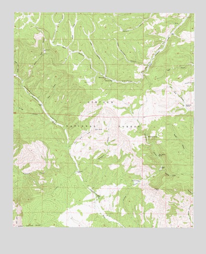
Rogers Ruins, NM USGS Topographic Map
Click on map above to begin viewing in our Map Viewer.

This topographic map contains these locations and features:
Feature Name Type Latitude Longitude GNIS ID View Map
Apple Tree CanyonValleyN32.7129°W105.7480°903249View Map
Barrel SpringSpringN32.7124°W105.6863°903584View Map
Bear Wallow SpringSpringN32.6673°W105.6496°903689View Map
Board TankReservoirN32.6770°W105.6369°913284View Map
Bridge CanyonValleyN32.6868°W105.7244°904078View Map
Carrisa SpringSpringN32.6523°W105.6619°904795View Map
Chilcoote CanyonValleyN32.6582°W105.6489°905094View Map
Circle Cross RanchLocaleN32.6575°W105.7058°905167View Map
CrispPopulated PlaceN32.7382°W105.6394°936809View Map
Crisp RanchLocaleN32.7379°W105.6411°905507View Map
Fairchild RanchLocaleN32.6959°W105.7300°906219View Map
Four H CampLocaleN32.7276°W105.7286°906349View Map
Graveyard CanyonValleyN32.6518°W105.7014°906718View Map
Harris CanyonValleyN32.7420°W105.7205°906851View Map
Holcomb RanchLocaleN32.6598°W105.6478°907019View Map
Jefferies PeakSummitN32.6473°W105.6478°907338View Map
Jim Lewis SpringSpringN32.6962°W105.6316°907371View Map
Logan CanyonValleyN32.7134°W105.6875°908122View Map
Logan TankReservoirN32.7402°W105.6942°913282View Map
Monument CanyonValleyN32.6582°W105.6489°908868View Map
Monument OverlookLocaleN32.6804°W105.6694°1987970View Map
Monument SpringSpringN32.6782°W105.6572°908879View Map
Moss RanchLocaleN32.6423°W105.6914°908926View Map
Rogers RuinsLocaleN32.7095°W105.6969°910414View Map
Rogers TankReservoirN32.7102°W105.6944°913283View Map
Sacramento CanyonValleyN32.6698°W105.7114°910503View Map
Sand SpringsSpringN32.7104°W105.6814°910735View Map
Scott Able CanyonValleyN32.7098°W105.7436°910883View Map
Spiller CanyonValleyN32.6962°W105.7289°911304View Map
Sulfur SpringSpringN32.6824°W105.6938°911469View Map
Sulfur Spring CanyonValleyN32.6715°W105.7122°911470View Map
Timberon AirportAirportN32.6291°W105.6830°936888View Map
Timberon Census Designated PlaceCensusN32.6360°W105.6924°2409323View Map
Timberon LodgeLocaleN32.6418°W105.6903°913285View Map
Timberon Volunteer Fire Department Station 1BuildingN32.6410°W105.6917°2657803View Map
Timberon Volunteer Fire Department Station 2BuildingN32.6320°W105.7292°2657961View Map
Upper Pendleton CanyonValleyN32.7207°W105.6575°912001View Map
Wood TankReservoirN32.7452°W105.7067°913281View Map
Woods CanyonValleyN32.7293°W105.7128°912493View Map

Note: Coordinates in the location and feature list above are referenced to NAD83 datum.


Copyright (C) 2008-2024 Ryan Niemi / Sunset Dynamics ... All Rights Reserved