TopoQuest Logo
Do you find TopoQuest useful?
Help keep TopoQuest running and adding new maps/features by donating!
Bitcoin:  19c7KJd3qBynnjoSw5npx9KScwjBe4ifkT
Litecoin:  LXs6TkuXGGXo1vDsWCkWVdjQX94eUKd6ui
Home View Maps Find Maps Find Places Resources & Links


Romayor, Texas Topographic Map

USGS Map Title: Romayor, TX
USGS Map MRC: 30094D7
DRG (GeoTIFF) Download: o30094d7.tif


Neighboring USGS Topographic Map Quads:


  Goodrich, TX  
30094E8
 

  Schwab City, TX  
30094E7
 

  Segno, TX  
30094E6
 

  Rayburn, TX  
30094D8
 

  Romayor, TX  
30094D7
 

  Votaw, TX  
30094D6
 

  Tarkington Prairie, TX  
30094C8
 

  Davis Hill, TX  
30094C7
 

  Arizona Creek, TX  
30094C6


Map MRC Location:

N31°
W95°
N31°
W94°
H8 H7 H6 H5 H4 H3 H2 H1
G8 G7 G6 G5 G4 G3 G2 G1
F8 F7 F6 F5 F4 F3 F2 F1
E8 E7 E6 E5 E4 E3 E2 E1
D8 D7 D6 D5 D4 D3 D2 D1
C8 C7 C6 C5 C4 C3 C2 C1
B8 B7 B6 B5 B4 B3 B2 B1
A8 A7 A6 A5 A4 A3 A2 A1
N30°
W95°
N30°
W94°

Romayor, TX USGS 1:24K Topographic Map Preview:
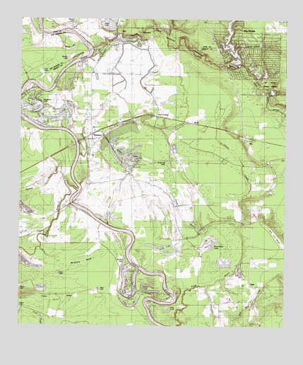
Romayor, TX USGS Topographic Map
Click on map above to begin viewing in our Map Viewer.

This topographic map contains these locations and features:
Feature Name Type Latitude Longitude GNIS ID View Map
6 Lakes Estates Lake Number 3 DamDamN30.4935°W94.8285°1862926View Map
6 Lakes Estates Lake Number 4 DamDamN30.4935°W94.8252°1862924View Map
6 Lakes Estates Lake Number 5ReservoirN30.4935°W94.8202°1861959View Map
6 Lakes Estates Lake Number 5 DamDamN30.4935°W94.8202°1861958View Map
Bearfoot LakeReservoirN30.4885°W94.7785°1861961View Map
Bearfoot Lake DamDamN30.4885°W94.7785°1861960View Map
Big CreekPopulated PlaceN30.4524°W94.8627°1377136View Map
Big Greek StationBuildingN30.4424°W94.8627°1377093View Map
Big Thicket Creekmore VillagePopulated PlaceN30.4774°W94.7752°1384190View Map
Big Thicket Lake Estates Census Designated PlaceCensusN30.4874°W94.7679°2586910View Map
Big Thicket Lake Estates Volunteer Fire DepartmentBuildingN30.4835°W94.7801°2334318View Map
Big Thicket Menard CreekStreamN30.4960°W94.8022°1384200View Map
Black LakeLakeN30.3900°W94.8370°1352332View Map
Brushy LakeLakeN30.4978°W94.8509°1372778View Map
Brushy LakeLakeN30.4003°W94.8263°1353068View Map
Brushy LakeLakeN30.4844°W94.8524°1353069View Map
Chain O'LakesLakeN30.4450°W94.8237°1354252View Map
Cherry CreekStreamN30.4116°W94.7769°1354354View Map
ClarkPopulated PlaceN30.3922°W94.7663°1379552View Map
Concord ChurchChurchN30.4172°W94.7694°1354856View Map
Coon SloughGutN30.3805°W94.8677°1373200View Map
Duke LakeReservoirN30.4977°W94.8341°1356428View Map
Duke Lake DamDamN30.4969°W94.8335°1854333View Map
F R Duke Farm AirportAirportN30.4781°W94.8332°1387421View Map
Fields BayouStreamN30.3760°W94.8005°1357313View Map
Fields CemeteryCemeteryN30.3791°W94.7813°1357315View Map
Green ChapelChurchN30.4349°W94.8169°1358373View Map
Hank CemeteryCemeteryN30.3988°W94.7716°1358728View Map
Hardwood LakeLakeN30.4417°W94.8061°1358783View Map
Horn Crossing ChurchChurchN30.4613°W94.8105°1359569View Map
Horseshoe LakeLakeN30.4648°W94.8684°1359650View Map
Indian RidgeRidgeN30.3855°W94.8583°1377844View Map
Lake Number 3ReservoirN30.4935°W94.8285°1862927View Map
Lake Number 4ReservoirN30.4935°W94.8252°1862925View Map
Long LakeLakeN30.3830°W94.8226°1361748View Map
Long LakeReservoirN30.4068°W94.8071°1361752View Map
Lost LakeLakeN30.4780°W94.8663°1361829View Map
MarvelsPopulated PlaceN30.4349°W94.7669°1377113View Map
Mason LakeLakeN30.3892°W94.8132°1364475View Map
Mason Lake EstatesPopulated PlaceN30.3877°W94.8044°1384191View Map
McAnally BreakSwampN30.4010°W94.8480°1362358View Map
McNulty CemeteryCemeteryN30.3852°W94.7652°1362537View Map
Menard CreekStreamN30.4891°W94.8405°1362611View Map
Mill CreekStreamN30.4816°W94.7752°1362864View Map
MilvidPopulated PlaceN30.4585°W94.7966°1380200View Map
Nevill BayouStreamN30.4302°W94.8480°1382379View Map
New River LakeLakeN30.3874°W94.8230°1363771View Map
North Liberty County Fire DepartmentBuildingN30.4500°W94.8390°2334348View Map
Oneal LakeReservoirN30.4569°W94.8552°1863832View Map
Oneal Lake DamDamN30.4569°W94.8552°1863831View Map
Pond 1 DamDamN30.4869°W94.8402°1865541View Map
Rebekah ChurchChurchN30.3905°W94.7660°1366092View Map
RomayorPopulated PlaceN30.4513°W94.8433°1366839View Map
Romayor Post OfficePost OfficeN30.4513°W94.8433°2731346View Map
RyePopulated PlaceN30.4527°W94.7688°1367062View Map
Rye Post OfficePost OfficeN30.4515°W94.7683°2731325View Map
Sand LakeReservoirN30.3966°W94.8568°1367627View Map
Stub LakeReservoirN30.3811°W94.8054°1369297View Map
Ward Prairie LakesLakeN30.4089°W94.7858°1370851View Map
White RoselakeLakeN30.3947°W94.8030°1377106View Map
Williams CreekStreamN30.4941°W94.8069°1371569View Map
Williams SpringSpringN30.4905°W94.8308°1998521View Map
Woods LakeLakeN30.4879°W94.8525°1371929View Map

Note: Coordinates in the location and feature list above are referenced to NAD83 datum.


Copyright (C) 2008-2025 Ryan Niemi / Sunset Dynamics ... All Rights Reserved