TopoQuest Logo
Do you find TopoQuest useful?
Help keep TopoQuest running and adding new maps/features by donating!
Bitcoin:  19c7KJd3qBynnjoSw5npx9KScwjBe4ifkT
Litecoin:  LXs6TkuXGGXo1vDsWCkWVdjQX94eUKd6ui
Home View Maps Find Maps Find Places Resources & Links


Romeo, Florida Topographic Map

USGS Map Title: Romeo, FL
USGS Map MRC: 29082B4
DRG (GeoTIFF) Download: o29082b4.tif


Neighboring USGS Topographic Map Quads:


  Bronson SE, FL  
29082C5
 

  Morriston, FL  
29082C4
 

  Fairfield, FL  
29082C3
 

  Tidewater, FL  
29082B5
 

  Romeo, FL  
29082B4
 

  Cotton Plant, FL  
29082B3
 

  Yankeetown SE, FL  
29082A5
 

  Dunnellon, FL  
29082A4
 

  Dunnellon SE, FL  
29082A3


Map MRC Location:

N30°
W83°
N30°
W82°
H8 H7 H6 H5 H4 H3 H2 H1
G8 G7 G6 G5 G4 G3 G2 G1
F8 F7 F6 F5 F4 F3 F2 F1
E8 E7 E6 E5 E4 E3 E2 E1
D8 D7 D6 D5 D4 D3 D2 D1
C8 C7 C6 C5 C4 C3 C2 C1
B8 B7 B6 B5 B4 B3 B2 B1
A8 A7 A6 A5 A4 A3 A2 A1
N29°
W83°
N29°
W82°

Romeo, FL USGS 1:24K Topographic Map Preview:
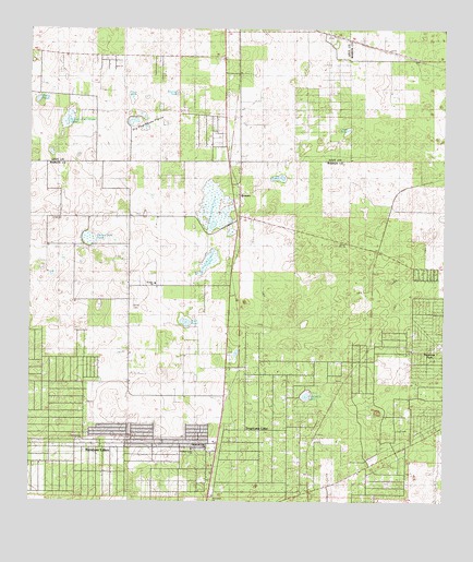
Romeo, FL USGS Topographic Map
Click on map above to begin viewing in our Map Viewer.

This topographic map contains these locations and features:
Feature Name Type Latitude Longitude GNIS ID View Map
Buck PondLakeN29.1728°W82.4527°279586View Map
Calvary Baptist TempleChurchN29.1422°W82.4834°2054577View Map
Cornerstone Church (historical)ChurchN29.1408°W82.4840°304827View Map
Dinner Sink PondSwampN29.1947°W82.4822°281578View Map
Dry Cow House PrairieFlatN29.2241°W82.4648°281792View Map
HoytPopulated PlaceN29.1658°W82.3976°295364View Map
Kitchen Cow House PondLakeN29.2264°W82.4885°285153View Map
Little Pine Island PrairieSwampN29.1892°W82.4453°285761View Map
LuddersvillePopulated PlaceN29.1591°W82.4407°308570View Map
Marion County Fire Rescue Station 25 Lake TropicanaBuildingN29.1546°W82.4151°2644257View Map
Mooney PondLakeN29.2333°W82.4557°287093View Map
Moore PondLakeN29.2314°W82.4974°287108View Map
Morningside Baptist ChurchChurchN29.1394°W82.4504°2054578View Map
Oak PondLakeN29.2238°W82.4038°287984View Map
Pine Island PrairieSwampN29.2031°W82.4444°298027View Map
Priest PondLakeN29.2320°W82.4689°289315View Map
Rainbow Lake Baptist Church (historical)ChurchN29.1391°W82.4509°304825View Map
Rainbow Lakes EstatesPopulated PlaceN29.1461°W82.4993°303887View Map
Rainbow Lakes Estates Fire DepartmentBuildingN29.1498°W82.4828°2056428View Map
Rainbow Lakes United Methodist ChurchChurchN29.1389°W82.4465°304824View Map
Riverland Baptist ChurchChurchN29.1272°W82.4473°304826View Map
RomeoPopulated PlaceN29.2064°W82.4362°294911View Map
Romeo Baptist ChurchChurchN29.1825°W82.4612°294642View Map
Romeo Elementary SchoolSchoolN29.1519°W82.4472°2054576View Map
WTRS-FM (Dunnellon)TowerN29.1880°W82.3940°310180View Map
Zion Hill CemeteryCemeteryN29.1777°W82.4673°293624View Map

Note: Coordinates in the location and feature list above are referenced to NAD83 datum.


Copyright (C) 2008-2024 Ryan Niemi / Sunset Dynamics ... All Rights Reserved