TopoQuest Logo
Do you find TopoQuest useful?
Help keep TopoQuest running and adding new maps/features by donating!
Bitcoin:  19c7KJd3qBynnjoSw5npx9KScwjBe4ifkT
Litecoin:  LXs6TkuXGGXo1vDsWCkWVdjQX94eUKd6ui
Home View Maps Find Maps Find Places Resources & Links


Rosamond, California Topographic Map

USGS Map Title: Rosamond, CA
USGS Map MRC: 34118G2
DRG (GeoTIFF) Download: o34118g2.tif


Neighboring USGS Topographic Map Quads:


  Willow Springs, CA  
34118H3
 

  Soledad Mountain, CA  
34118H2
 

  Bissell, CA  
34118H1
 

  Little Buttes, CA  
34118G3
 

  Rosamond, CA  
34118G2
 

  Rosamond Lake, CA  
34118G1
 

  Del Sur, CA  
34118F3
 

  Lancaster West, CA  
34118F2
 

  Lancaster East, CA  
34118F1


Map MRC Location:

N35°
W119°
N35°
W118°
H8 H7 H6 H5 H4 H3 H2 H1
G8 G7 G6 G5 G4 G3 G2 G1
F8 F7 F6 F5 F4 F3 F2 F1
E8 E7 E6 E5 E4 E3 E2 E1
D8 D7 D6 D5 D4 D3 D2 D1
C8 C7 C6 C5 C4 C3 C2 C1
B8 B7 B6 B5 B4 B3 B2 B1
A8 A7 A6 A5 A4 A3 A2 A1
N34°
W119°
N34°
W118°

Rosamond, CA USGS 1:24K Topographic Map Preview:
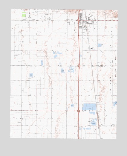
Rosamond, CA USGS Topographic Map
Click on map above to begin viewing in our Map Viewer.

This topographic map contains these locations and features:
Feature Name Type Latitude Longitude GNIS ID View Map
A Andrews RanchLocaleN34.7689°W118.2362°1693365View Map
Amargosa CreekStreamN34.7819°W118.1298°269509View Map
Assembly of God ChurchChurchN34.8625°W118.1712°1839470View Map
Avenue E Trailer ParkPopulated PlaceN34.7633°W118.1447°2129075View Map
Clarke ClubLocaleN34.7647°W118.1537°1669840View Map
Exit 49CrossingN34.7769°W118.1708°2128997View Map
Exit 52CrossingN34.8206°W118.1706°2128998View Map
First Southern Baptist ChurchChurchN34.8608°W118.1676°1839480View Map
Gaskill RanchLocaleN34.8250°W118.2367°1733254View Map
Glendale Rod and Gun ClubLocaleN34.7791°W118.1781°1669859View Map
Hamilton Elementary School (historical)SchoolN34.8650°W118.1831°1839486View Map
Hoffman ClubLocaleN34.7750°W118.1545°1669864View Map
Hummel HallBuildingN34.8603°W118.1670°1839487View Map
KAVC-FM (Rosamond)TowerN34.8508°W118.1570°1665077View Map
KAVR-AM (Rosamond)TowerN34.8508°W118.1570°1664924View Map
Kern County Fire Department Station 15 RosamondBuildingN34.8672°W118.1941°2665353View Map
Kern County Sheriff's DepartmentBuildingN34.8407°W118.1598°2756323View Map
Kern County Union SchoolSchoolN34.8653°W118.1665°1733255View Map
Lancaster Water Reclamation PlantLocaleN34.7808°W118.1583°2351483View Map
Liberty Flying School (historical)SchoolN34.8022°W118.1579°1693366View Map
New Life Church of God in ChristChurchN34.8533°W118.2379°1839495View Map
ObanPopulated PlaceN34.7744°W118.1481°252948View Map
Rainbow Farms (historical)LocaleN34.8039°W118.1270°1733134View Map
RosamondPopulated PlaceN34.8641°W118.1634°1661329View Map
Rosamond Branch Kern County LibraryBuildingN34.8641°W118.1890°1839496View Map
Rosamond Census Designated PlaceCensusN34.8658°W118.2155°2409208View Map
Rosamond Chamber of CommerceBuildingN34.8614°W118.1645°1839497View Map
Rosamond Christian SchoolSchoolN34.8683°W118.1698°1839498View Map
Rosamond High SchoolSchoolN34.8650°W118.1824°248367View Map
Rosamond ParkParkN34.8675°W118.1684°1839499View Map
Rosamond Post OfficePost OfficeN34.8638°W118.1667°1839500View Map
Rosamond SkyparkAirportN34.8697°W118.2060°1653894View Map
Saint Mary of the Desert ChurchChurchN34.8658°W118.1581°1839501View Map
Tropico Middle SchoolSchoolN34.8667°W118.2281°250633View Map
Wayside Chapel Community ChurchChurchN34.8683°W118.1698°1839503View Map
Willow Springs ChurchChurchN34.8650°W118.1556°1839504View Map

Note: Coordinates in the location and feature list above are referenced to NAD83 datum.


Copyright (C) 2008-2025 Ryan Niemi / Sunset Dynamics ... All Rights Reserved