TopoQuest Logo
Do you find TopoQuest useful?
Help keep TopoQuest running and adding new maps/features by donating!
Bitcoin:  19c7KJd3qBynnjoSw5npx9KScwjBe4ifkT
Litecoin:  LXs6TkuXGGXo1vDsWCkWVdjQX94eUKd6ui
Home View Maps Find Maps Find Places Resources & Links


Round Pond, Arkansas Topographic Map

USGS Map Title: Round Pond, AR
USGS Map MRC: 35090A5
DRG (GeoTIFF) Download: o35090a5.tif


Neighboring USGS Topographic Map Quads:


  Wittsburg, AR  
35090B6
 

  Gieseck, AR  
35090B5
 

  Jeanette, AR  
35090B4
 

  Madison, AR  
35090A6
 

  Round Pond, AR  
35090A5
 

  Chatfield, AR  
35090A4
 

  Dansby, AR  
34090H6
 

  Mud Lake, AR  
34090H5
 

  Hughes, AR  
34090H4


Map MRC Location:

N36°
W91°
N36°
W90°
H8 H7 H6 H5 H4 H3 H2 H1
G8 G7 G6 G5 G4 G3 G2 G1
F8 F7 F6 F5 F4 F3 F2 F1
E8 E7 E6 E5 E4 E3 E2 E1
D8 D7 D6 D5 D4 D3 D2 D1
C8 C7 C6 C5 C4 C3 C2 C1
B8 B7 B6 B5 B4 B3 B2 B1
A8 A7 A6 A5 A4 A3 A2 A1
N35°
W91°
N35°
W90°

Round Pond, AR USGS 1:24K Topographic Map Preview:
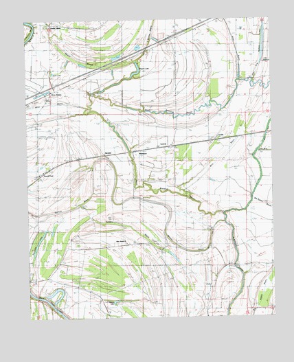
Round Pond, AR USGS Topographic Map
Click on map above to begin viewing in our Map Viewer.

This topographic map contains these locations and features:
Feature Name Type Latitude Longitude GNIS ID View Map
Allen BayouStreamN35.0881°W90.5940°83062View Map
Allen BayouStreamN35.0995°W90.5157°83063View Map
Beaver LakeLakeN35.0070°W90.5810°83067View Map
Beaver SloughStreamN35.1079°W90.5693°83069View Map
Bethlehem ChurchChurchN35.0168°W90.6196°83075View Map
Bills BayouStreamN35.0593°W90.5348°83081View Map
BlackfishPopulated PlaceN35.0662°W90.5820°83082View Map
Blackfish School (historical)SchoolN35.0218°W90.5257°1730618View Map
Burnt Cane ChurchChurchN35.0090°W90.5873°83091View Map
CicallaPopulated PlaceN35.0743°W90.5287°83101View Map
Clarks CornerPopulated PlaceN35.1234°W90.6121°83103View Map
Dillon FerryLocaleN35.1231°W90.6209°83124View Map
Ditch Number 26CanalN35.1009°W90.5082°83133View Map
Farm Service Agency Interest of ArkansasParkN35.0568°W90.5944°2765595View Map
Hicks StationPopulated PlaceN35.0943°W90.6129°83169View Map
Hillclark School (historical)SchoolN35.1240°W90.5843°1730621View Map
Interchange 256CrossingN35.1187°W90.5482°82873View Map
Islam Church (historical)ChurchN35.0659°W90.6198°1730622View Map
Johnson BendBendN35.1201°W90.6215°82895View Map
Little Bivens BayouStreamN35.1084°W90.5693°83198View Map
LucernePopulated PlaceN35.0715°W90.5582°83207View Map
Macedonia ChurchChurchN35.0904°W90.5495°83209View Map
Macedonia School (historical)SchoolN35.0898°W90.5515°1730623View Map
New HomePopulated PlaceN35.0323°W90.5765°82875View Map
New Home ChurchChurchN35.0304°W90.5851°83229View Map
New Home School (historical)SchoolN35.0301°W90.5862°1730625View Map
Nichols LakeLakeN35.1150°W90.5040°83237View Map
North Blackfish BayouStreamN35.0431°W90.5254°83328View Map
Pettijohn LakeLakeN35.0336°W90.6186°83245View Map
Pilgrim Rest ChurchChurchN35.1243°W90.5840°83247View Map
Round PondLakeN35.0551°W90.6112°83260View Map
Round PondPopulated PlaceN35.0626°W90.6196°83330View Map
Round Pond Methodist ChurchChurchN35.0615°W90.6168°83017View Map
Round Pond Post Office (historical)Post OfficeN35.0606°W90.6184°1730629View Map
Rush LakeLakeN35.1023°W90.6123°83263View Map
Shiloh ChurchChurchN35.0204°W90.5248°83286View Map
Spencer BayouStreamN35.0398°W90.5243°83290View Map
Spring CreekStreamN35.0434°W90.5251°83291View Map
Tenmile BayouStreamN35.0481°W90.5987°83303View Map
Township of GriggsCivilN35.0658°W90.6091°82860View Map
WhitmorePopulated PlaceN35.0695°W90.5682°83318View Map
Whitmore CemeteryCemeteryN35.0534°W90.5704°83319View Map
Wiggins LakeLakeN35.1027°W90.5691°83321View Map

Note: Coordinates in the location and feature list above are referenced to NAD83 datum.


Copyright (C) 2008-2025 Ryan Niemi / Sunset Dynamics ... All Rights Reserved