TopoQuest Logo
Do you find TopoQuest useful?
Help keep TopoQuest running and adding new maps/features by donating!
Bitcoin:  19c7KJd3qBynnjoSw5npx9KScwjBe4ifkT
Litecoin:  LXs6TkuXGGXo1vDsWCkWVdjQX94eUKd6ui
Home View Maps Find Maps Find Places Resources & Links


Dansby, Arkansas Topographic Map

USGS Map Title: Dansby, AR
USGS Map MRC: 34090H6
DRG (GeoTIFF) Download: o34090h6.tif


Neighboring USGS Topographic Map Quads:


  Forrest City, AR  
35090A7
 

  Madison, AR  
35090A6
 

  Round Pond, AR  
35090A5
 

  Haynes, AR  
34090H7
 

  Dansby, AR  
34090H6
 

  Mud Lake, AR  
34090H5
 

  Marianna, AR  
34090G7
 

  Soudan, AR  
34090G6
 

  Brickeys, AR  
34090G5


Map MRC Location:

N35°
W91°
N35°
W90°
H8 H7 H6 H5 H4 H3 H2 H1
G8 G7 G6 G5 G4 G3 G2 G1
F8 F7 F6 F5 F4 F3 F2 F1
E8 E7 E6 E5 E4 E3 E2 E1
D8 D7 D6 D5 D4 D3 D2 D1
C8 C7 C6 C5 C4 C3 C2 C1
B8 B7 B6 B5 B4 B3 B2 B1
A8 A7 A6 A5 A4 A3 A2 A1
N34°
W91°
N34°
W90°

Dansby, AR USGS 1:24K Topographic Map Preview:
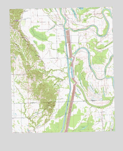
Dansby, AR USGS Topographic Map
Click on map above to begin viewing in our Map Viewer.

This topographic map contains these locations and features:
Feature Name Type Latitude Longitude GNIS ID View Map
Berry BendBendN34.9931°W90.6868°82918View Map
Blackfish BayouStreamN34.9290°W90.6254°83083View Map
Blackfish Cut-offChannelN34.9204°W90.6257°82919View Map
Blunt Church (historical)ChurchN34.9712°W90.6437°83047View Map
Blunt School (historical)SchoolN34.9712°W90.6437°83048View Map
Brush Arbor Church (historical)ChurchN34.8904°W90.7384°81639View Map
Casteel CemeteryCemeteryN34.9020°W90.7007°47517View Map
Castell CrossingCrossingN34.9848°W90.6826°82921View Map
Church of ChristChurchN34.9709°W90.7309°82922View Map
Church of GodChurchN34.8943°W90.6421°59533View Map
Clay HillLocaleN34.8759°W90.7298°47815View Map
Clay Hill CemeteryCemeteryN34.8773°W90.7287°59536View Map
Coon Island BendBendN34.9795°W90.6301°82923View Map
Creely BayouGutN34.9590°W90.6373°83112View Map
Creely BendBendN34.9715°W90.6421°82925View Map
Danford School (historical)SchoolN34.8945°W90.6415°81640View Map
DansbyPopulated PlaceN34.8943°W90.6404°48354View Map
Dansby CemeteryCemeteryN34.8851°W90.6432°48355View Map
Dansby School (historical)SchoolN34.8912°W90.6398°59531View Map
Don LakeLakeN34.9117°W90.6700°83138View Map
Dry LakeLakeN34.8789°W90.6625°74803View Map
Fairview School (historical)SchoolN34.9054°W90.6929°81642View Map
Hawkins CreekStreamN34.8779°W90.7234°83166View Map
Hidden SloughGutN34.9890°W90.6546°83170View Map
Island LakeLakeN34.9993°W90.6641°83179View Map
Jarvis BendBendN34.9765°W90.6709°82928View Map
Jarvis CrossingCrossingN34.9776°W90.6737°82929View Map
Linden CemeteryCemeteryN34.9265°W90.6918°83194View Map
Linden IslandIslandN34.9251°W90.6582°83195View Map
Loeb LakeReservoirN34.9886°W90.7419°83349View Map
Loeb Lake DamDamN34.9884°W90.7401°83348View Map
Long LakeLakeN34.9259°W90.6657°83204View Map
Long LakeLakeN34.9946°W90.6715°83205View Map
Macedonia ChurchChurchN34.9979°W90.7326°83208View Map
McDaniel School (historical)SchoolN34.9354°W90.6515°82932View Map
McDonald CrossingCrossingN34.9840°W90.6301°82933View Map
Miller CrossingCrossingN34.9784°W90.6307°82934View Map
Mount Zion CemeteryCemeteryN34.9676°W90.7320°83218View Map
Mount Zion ChurchChurchN34.9531°W90.7154°83220View Map
Mount Zion Church (historical)ChurchN34.9681°W90.7323°83051View Map
Old RiverLakeN34.9414°W90.6536°83239View Map
Old RiverSwampN34.9018°W90.6529°83240View Map
Overcup BendBendN34.9981°W90.6334°82935View Map
Peters Rock ChurchChurchN34.9226°W90.6932°83244View Map
Pettis CrossingCrossingN34.9806°W90.6454°82936View Map
Pleasant Grove Church (historical)ChurchN34.9284°W90.6471°83053View Map
Pleasant Grove School (historical)SchoolN34.9284°W90.6471°83054View Map
Point Look AboutCapeN34.9973°W90.6329°82938View Map
Point Look AroundCapeN34.9876°W90.6332°82939View Map
Point Look OutCapeN34.9898°W90.6262°82940View Map
Poplar CreekStreamN34.9334°W90.6801°83251View Map
Poplar Creek School (historical)SchoolN34.9384°W90.6784°83056View Map
Pretty Tree BendBendN34.9815°W90.6465°82942View Map
Quigley BendBendN34.9795°W90.6843°82943View Map
Quigley CrossingCrossingN34.9918°W90.6851°82944View Map
RiversidePopulated PlaceN34.9723°W90.6668°82945View Map
Riverview Church (historical)ChurchN34.9365°W90.6523°82946View Map
Riverview School (historical)SchoolN34.9301°W90.6479°83057View Map
Rocky BranchStreamN34.9056°W90.6821°83259View Map
Rollinson (historical)Populated PlaceN34.9251°W90.6279°82947View Map
Saint John CemeteryCemeteryN34.9840°W90.6859°82949View Map
Saint John ChurchChurchN34.9837°W90.6862°83268View Map
Saint John School (historical)SchoolN34.9831°W90.6862°82950View Map
Sassafrass BendBendN34.9781°W90.6573°82951View Map
School House BendBendN34.9873°W90.6254°83273View Map
Shady Grove CemeteryCemeteryN34.9340°W90.7359°83276View Map
Shady Grove School (historical)SchoolN34.9326°W90.7473°82953View Map
Skinny LakeLakeN34.9794°W90.6996°83288View Map
Taylor ChapelChurchN34.8918°W90.6398°59532View Map
Township of FranksCivilN34.9454°W90.7365°82857View Map
TuniPopulated PlaceN34.9404°W90.7090°82954View Map
Tuni Church (historical)ChurchN34.9362°W90.7090°82955View Map
Tuni CreekStreamN34.9401°W90.6807°83307View Map
TuttletonPopulated PlaceN34.9306°W90.6932°83029View Map
Tuttleton School (historical)SchoolN34.9306°W90.6946°82956View Map
Union ChurchChurchN34.8759°W90.7434°55802View Map
Union School (historical)SchoolN34.8759°W90.7432°59535View Map
White Rock School (historical)SchoolN34.9929°W90.6826°82959View Map
White Wall School (historical)SchoolN34.8901°W90.7301°59534View Map
Wyles (historical)Populated PlaceN34.9598°W90.7068°83060View Map
Wyles CemeteryCemeteryN34.9473°W90.7120°83325View Map
Wyles Pond SloughStreamN34.9520°W90.6821°83326View Map
Wyles School (historical)SchoolN34.9518°W90.7148°82961View Map

Note: Coordinates in the location and feature list above are referenced to NAD83 datum.


Copyright (C) 2008-2024 Ryan Niemi / Sunset Dynamics ... All Rights Reserved