TopoQuest Logo
Do you find TopoQuest useful?
Help keep TopoQuest running and adding new maps/features by donating!
Bitcoin:  19c7KJd3qBynnjoSw5npx9KScwjBe4ifkT
Litecoin:  LXs6TkuXGGXo1vDsWCkWVdjQX94eUKd6ui
Home View Maps Find Maps Find Places Resources & Links


Roundhead, Ohio Topographic Map

USGS Map Title: Roundhead, OH
USGS Map MRC: 40083E7
DRG (GeoTIFF) Download: o40083e7.tif


Neighboring USGS Topographic Map Quads:


  Harrod, OH  
40083F8
 

  Alger, OH  
40083F7
 

  Foraker, OH  
40083F6
 

  Waynesfield, OH  
40083E8
 

  Roundhead, OH  
40083E7
 

  Silver Creek, OH  
40083E6
 

  Russells Point, OH  
40083D8
 

  Huntsville, OH  
40083D7
 

  Rushsylvania, OH  
40083D6


Map MRC Location:

N41°
W84°
N41°
W83°
H8 H7 H6 H5 H4 H3 H2 H1
G8 G7 G6 G5 G4 G3 G2 G1
F8 F7 F6 F5 F4 F3 F2 F1
E8 E7 E6 E5 E4 E3 E2 E1
D8 D7 D6 D5 D4 D3 D2 D1
C8 C7 C6 C5 C4 C3 C2 C1
B8 B7 B6 B5 B4 B3 B2 B1
A8 A7 A6 A5 A4 A3 A2 A1
N40°
W84°
N40°
W83°

Roundhead, OH USGS 1:24K Topographic Map Preview:
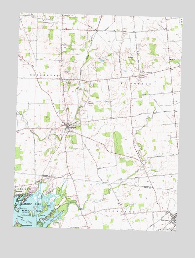
Roundhead, OH USGS Topographic Map
Click on map above to begin viewing in our Map Viewer.

This topographic map contains these locations and features:
Feature Name Type Latitude Longitude GNIS ID View Map
Anstine HillSummitN40.5920°W83.8385°1963544View Map
AvondalePopulated PlaceN40.5206°W83.8735°1084643View Map
Belle Center - McDonald - Richland - Taylor Creek Townships Ambulance DistrictBuildingN40.5087°W83.7507°2550735View Map
Belle Center Church of ChristChurchN40.5053°W83.7502°1060785View Map
Belle Center United Methodist ChurchChurchN40.5064°W83.7505°1060786View Map
Big Walnut IsleIslandN40.5087°W83.8602°1060874View Map
Bowdle CemeteryCemeteryN40.5978°W83.8716°1038218View Map
Breese School (historical)SchoolN40.5564°W83.8610°1055403View Map
Diamond D RanchLocaleN40.5897°W83.7986°2647870View Map
Ewing IslandIslandN40.5098°W83.8722°1040292View Map
Fairview CemeteryCemeteryN40.5914°W83.7772°1040334View Map
Harmony School (historical)SchoolN40.5681°W83.7541°1055430View Map
Hinkle CemeteryCemeteryN40.5873°W83.8410°1041619View Map
Hinkle School (historical)SchoolN40.5939°W83.8424°1055433View Map
JumboPopulated PlaceN40.5951°W83.7580°1042162View Map
Jumbo Post Office (historical)Post OfficeN40.5945°W83.7680°1992748View Map
JumpPopulated PlaceN40.6159°W83.7944°1048881View Map
Jump Post Office (historical)Post OfficeN40.6167°W83.7944°1992749View Map
Lawrence School (historical)SchoolN40.5703°W83.7880°1055440View Map
Little Walnut IsleIslandN40.5092°W83.8624°1057811View Map
Long IslandIslandN40.5048°W83.8516°1042726View Map
Long Island Golf CourseLocaleN40.5145°W83.8388°1055047View Map
McArthur CemeteryCemeteryN40.5809°W83.8213°1043081View Map
Mount Zion ChurchChurchN40.5995°W83.7583°1043663View Map
New Roundhead CemeteryCemeteryN40.5609°W83.8299°1700966View Map
North Fork Great Miami RiverStreamN40.5003°W83.8522°1043903View Map
North Fork School (historical)SchoolN40.5073°W83.8208°1055053View Map
Old Fairview CemeteryCemeteryN40.5895°W83.7805°1044089View Map
Old Roundhead CemeteryCemeteryN40.5603°W83.8338°1700967View Map
Pleasant Hill CemeteryCemeteryN40.6237°W83.8413°1700890View Map
Pleasant Hill Methodist ChurchChurchN40.6239°W83.8408°1044559View Map
Pleasant Hill School (historical)SchoolN40.6189°W83.8424°1055461View Map
Poe DitchCanalN40.6045°W83.8333°1044655View Map
Pony IslandIslandN40.5123°W83.8502°1044682View Map
Red School (historical)SchoolN40.5878°W83.8072°1055463View Map
Richland Township Fire DepartmentBuildingN40.5082°W83.7514°2549878View Map
Roberts School (historical)SchoolN40.5403°W83.7791°1055468View Map
Roebuck School (historical)SchoolN40.5095°W83.7894°1055062View Map
RoundheadPopulated PlaceN40.5595°W83.8352°1065249View Map
Roundhead Elementary SchoolSchoolN40.5617°W83.8394°1055469View Map
Roundhead Post OfficePost OfficeN40.5598°W83.8347°1992727View Map
Roundhead United Methodist ChurchChurchN40.5601°W83.8372°1060783View Map
Roundhead Volunteer Fire DepartmentBuildingN40.5595°W83.8355°2549973View Map
Rutledge CemeteryCemeteryN40.5945°W83.8666°1700971View Map
Sassafras PointCapeN40.5162°W83.8733°1045968View Map
Seminole IslandIslandN40.5000°W83.8708°1046090View Map
Snow IslandIslandN40.5112°W83.8735°1058184View Map
South Walnut IsleIslandN40.5073°W83.8622°1058029View Map
Sport PointCapeN40.5067°W83.8558°1046538View Map
Street School (historical)SchoolN40.5942°W83.8608°1055479View Map
Tammis Mobile VillagePopulated PlaceN40.5281°W83.8475°2630935View Map
The PointsCapeN40.5050°W83.8719°1054193View Map
Tip and Jo's Trailer ParkPopulated PlaceN40.5953°W83.7589°2647867View Map
Township of McDonaldCivilN40.5915°W83.7745°1086265View Map
Township of RoundheadCivilN40.5915°W83.8482°1086268View Map
Turkeyfoot PointCapeN40.5134°W83.8688°1047215View Map
Upper Scioto Valley Ambulance District Roundhead StationBuildingN40.5595°W83.8355°2550814View Map

Note: Coordinates in the location and feature list above are referenced to NAD83 datum.


Copyright (C) 2008-2024 Ryan Niemi / Sunset Dynamics ... All Rights Reserved