TopoQuest Logo
Do you find TopoQuest useful?
Help keep TopoQuest running and adding new maps/features by donating!
Bitcoin:  19c7KJd3qBynnjoSw5npx9KScwjBe4ifkT
Litecoin:  LXs6TkuXGGXo1vDsWCkWVdjQX94eUKd6ui
Home View Maps Find Maps Find Places Resources & Links


Waynesfield, Ohio Topographic Map

USGS Map Title: Waynesfield, OH
USGS Map MRC: 40083E8
DRG (GeoTIFF) Download: o40083e8.tif


Neighboring USGS Topographic Map Quads:


  Lima, OH  
40084F1
 

  Harrod, OH  
40083F8
 

  Alger, OH  
40083F7
 

  Uniopolis, OH  
40084E1
 

  Waynesfield, OH  
40083E8
 

  Roundhead, OH  
40083E7
 

  Jackson Center, OH  
40084D1
 

  Russells Point, OH  
40083D8
 

  Huntsville, OH  
40083D7


Map MRC Location:

N41°
W84°
N41°
W83°
H8 H7 H6 H5 H4 H3 H2 H1
G8 G7 G6 G5 G4 G3 G2 G1
F8 F7 F6 F5 F4 F3 F2 F1
E8 E7 E6 E5 E4 E3 E2 E1
D8 D7 D6 D5 D4 D3 D2 D1
C8 C7 C6 C5 C4 C3 C2 C1
B8 B7 B6 B5 B4 B3 B2 B1
A8 A7 A6 A5 A4 A3 A2 A1
N40°
W84°
N40°
W83°

Waynesfield, OH USGS 1:24K Topographic Map Preview:
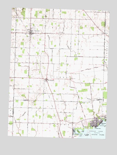
Waynesfield, OH USGS Topographic Map
Click on map above to begin viewing in our Map Viewer.

This topographic map contains these locations and features:
Feature Name Type Latitude Longitude GNIS ID View Map
Beehive School (historical)SchoolN40.5459°W83.9747°1054943View Map
Berry CemeteryCemeteryN40.6203°W83.8905°1037878View Map
Blackhawk IslandIslandN40.5070°W83.9102°1038090View Map
Blackhawk Mobile Home ParkPopulated PlaceN40.5050°W83.9167°2630936View Map
Blackhawk ParkParkN40.5028°W83.9130°1038091View Map
Blackhawk RunStreamN40.5175°W83.8780°1038092View Map
Chippewa IslandIslandN40.5100°W83.8888°1039077View Map
Chippewa ParkPopulated PlaceN40.5156°W83.8891°2633218View Map
Chippewa Park Census Designated PlaceCensusN40.5160°W83.8875°2628906View Map
Concord CemeteryCemeteryN40.6034°W83.9938°1070719View Map
East Lynn School (historical)SchoolN40.5723°W83.8799°1055412View Map
Elm Grove School (historical)SchoolN40.5167°W83.9749°1055026View Map
Fawn IslandIslandN40.5145°W83.8777°1040398View Map
Goshen School (historical)SchoolN40.5537°W83.9530°1070094View Map
HoldenPopulated PlaceN40.6026°W83.8802°1064847View Map
Holiday Shores Mobile Home ParkPopulated PlaceN40.5125°W83.9161°2630933View Map
Houchin School (historical)SchoolN40.5100°W83.9347°1055030View Map
Island ViewPopulated PlaceN40.5162°W83.8860°1048865View Map
Island View Post Office (historical)Post OfficeN40.5162°W83.8860°1926728View Map
Lone Oak School (historical)SchoolN40.5350°W83.9413°1055048View Map
Lucys PondReservoirN40.5073°W83.9061°1042826View Map
Manchester School (historical)SchoolN40.5534°W83.8980°1054957View Map
New HampshirePopulated PlaceN40.5562°W83.9527°1049007View Map
New Hampshire Census Designated PlaceCensusN40.5540°W83.9532°2628940View Map
New Hampshire Church of the NazareneChurchN40.5562°W83.9513°1071300View Map
New Hampshire Methodist ChurchChurchN40.5570°W83.9524°1071301View Map
New Hampshire Post OfficePost OfficeN40.5556°W83.9527°1958942View Map
Prairie Fork School (historical)SchoolN40.5792°W83.9236°1054967View Map
Red Oak IslandIslandN40.5125°W83.8763°1044896View Map
Sandee FarmsLocaleN40.6106°W83.8947°2630951View Map
School Number 1 (historical)SchoolN40.6084°W83.8908°1071313View Map
Scioto River DitchCanalN40.5645°W83.8991°1077613View Map
Township of GoshenCivilN40.5573°W83.9373°1085765View Map
Township of WayneCivilN40.6117°W83.9372°1085775View Map
Van Horn CemeteryCemeteryN40.5148°W83.9174°1047415View Map
Van Horn CreekStreamN40.5037°W83.9080°1047417View Map
Van Horn School (historical)SchoolN40.5248°W83.9172°1055102View Map
Village of WaynesfieldCivilN40.6024°W83.9734°2400116View Map
Wallace ForkStreamN40.5792°W83.8799°1047512View Map
Wallace Fork School (historical)SchoolN40.6009°W83.9238°1071017View Map
Walnut Hill CemeteryCemeteryN40.5578°W83.9222°1047520View Map
Wayne Township Fire and Rescue ServicesBuildingN40.6023°W83.9751°2549468View Map
WaynesfieldPopulated PlaceN40.6006°W83.9752°1047633View Map
Waynesfield Baptist ChurchChurchN40.6009°W83.9749°1071299View Map
Waynesfield High SchoolSchoolN40.6050°W83.9747°1054972View Map
Waynesfield Post OfficePost OfficeN40.6001°W83.9749°1958943View Map
Waynesfield United Methodist ChurchChurchN40.6006°W83.9763°1071298View Map
Waynesfield-Goshen Elementary SchoolSchoolN40.6053°W83.9733°1071018View Map
Willow Branch CemeteryCemeteryN40.6012°W83.9558°1047950View Map
Willow Branch School (historical)SchoolN40.6006°W83.9569°1071019View Map
Willow CreekStreamN40.5078°W83.9866°1066294View Map

Note: Coordinates in the location and feature list above are referenced to NAD83 datum.


Copyright (C) 2008-2025 Ryan Niemi / Sunset Dynamics ... All Rights Reserved