TopoQuest Logo
Do you find TopoQuest useful?
Help keep TopoQuest running and adding new maps/features by donating!
Bitcoin:  19c7KJd3qBynnjoSw5npx9KScwjBe4ifkT
Litecoin:  LXs6TkuXGGXo1vDsWCkWVdjQX94eUKd6ui
Home View Maps Find Maps Find Places Resources & Links


Rutland, Wisconsin Topographic Map

USGS Map Title: Rutland, WI
USGS Map MRC: 42089H3
DRG (GeoTIFF) Download: o42089h3.tif


Neighboring USGS Topographic Map Quads:


  Madison West, WI  
43089A4
 

  Madison East, WI  
43089A3
 

  Cottage Grove, WI  
43089A2
 

  Oregon, WI  
42089H4
 

  Rutland, WI  
42089H3
 

  Stoughton, WI  
42089H2
 

  Attica, WI  
42089G4
 

  Evansville, WI  
42089G3
 

  Cooksville, WI  
42089G2


Map MRC Location:

N43°
W90°
N43°
W89°
H8 H7 H6 H5 H4 H3 H2 H1
G8 G7 G6 G5 G4 G3 G2 G1
F8 F7 F6 F5 F4 F3 F2 F1
E8 E7 E6 E5 E4 E3 E2 E1
D8 D7 D6 D5 D4 D3 D2 D1
C8 C7 C6 C5 C4 C3 C2 C1
B8 B7 B6 B5 B4 B3 B2 B1
A8 A7 A6 A5 A4 A3 A2 A1
N42°
W90°
N42°
W89°

Rutland, WI USGS 1:24K Topographic Map Preview:
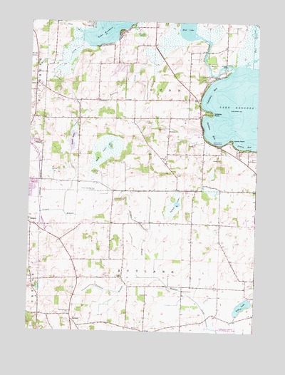
Rutland, WI USGS Topographic Map
Click on map above to begin viewing in our Map Viewer.

This topographic map contains these locations and features:
Feature Name Type Latitude Longitude GNIS ID View Map
Barbers BayBayN42.9561°W89.2754°1561159View Map
Bass LakeLakeN42.8855°W89.2570°1561227View Map
Bayview HeightsPopulated PlaceN42.9567°W89.2850°2515648View Map
Century Trout FarmLocaleN42.8936°W89.3461°2629141View Map
Colladay BayBayN42.9722°W89.2751°1563265View Map
Colladay PointCapeN42.9636°W89.2768°1563266View Map
Dewey BayBayN42.9506°W89.2562°1563951View Map
Door CreekStreamN42.9822°W89.2535°1564055View Map
Grass LakeLakeN42.9518°W89.3516°1565761View Map
Hook LakeLakeN42.9464°W89.3357°1566665View Map
Hook Lake Bog State Natural AreaParkN42.9361°W89.3348°1989927View Map
Island LakeLakeN42.9266°W89.2935°1567008View Map
Jaycee ParkParkN42.9278°W89.3740°1842481View Map
Lake KegonsaLakeN42.9646°W89.2536°1567373View Map
Lakeside SchoolSchoolN42.9561°W89.2982°1567784View Map
LakeviewPopulated PlaceN42.9753°W89.3721°1567790View Map
Lone Tree PointCapeN42.9814°W89.2632°1842505View Map
Lunds PointCapeN42.9519°W89.2646°1568810View Map
Mandt Farm and Equestrian CenterLocaleN42.9697°W89.3461°2629142View Map
Mc Manus Hoonch-Na-Shee-Kaw AirportAirportN42.9339°W89.3387°1581043View Map
Mud LakeLakeN42.9980°W89.2898°1569992View Map
Murphys CreekStreamN42.9922°W89.3468°1560660View Map
Oakside SchoolSchoolN42.9678°W89.3376°1570713View Map
Oregon BranchStreamN42.8967°W89.3135°1570855View Map
Oregon Farm CenterLocaleN42.9186°W89.3614°2629143View Map
Oregon High SchoolSchoolN42.9323°W89.3725°1842600View Map
Quams Marina Seaplane BaseAirportN42.9511°W89.2710°1582225View Map
Red Bridge CrossingCrossingN42.9881°W89.2782°1842629View Map
RutlandPopulated PlaceN42.8789°W89.3501°1572761View Map
Rutland BranchStreamN42.8967°W89.3135°1572762View Map
Rutland Center CemeteryCemeteryN42.8829°W89.3517°1572763View Map
Saint Johns Lutheran ChurchChurchN42.9364°W89.3726°1842654View Map
Spiegel FieldAirportN42.9124°W89.3536°2444189View Map
Swan CreekStreamN42.9956°W89.3473°1575160View Map
The Flower FactoryBuildingN42.8942°W89.3186°2629203View Map
Town of DunnCivilN42.9734°W89.3089°1583105View Map
Town of Dunn Burying GroundCemeteryN42.9676°W89.3470°2781302View Map
Town of RutlandCivilN42.8889°W89.3093°1584083View Map
Uff-Da AirportAirportN42.9455°W89.2868°2444188View Map
Waubesa Wetlands State Natural AreaParkN42.9878°W89.3532°1989575View Map
Willow Spring FarmsLocaleN42.9667°W89.3392°2629144View Map
WTSO-AM (Madison)TowerN42.9958°W89.3140°1582317View Map

Note: Coordinates in the location and feature list above are referenced to NAD83 datum.


Copyright (C) 2008-2025 Ryan Niemi / Sunset Dynamics ... All Rights Reserved