TopoQuest Logo
Do you find TopoQuest useful?
Help keep TopoQuest running and adding new maps/features by donating!
Bitcoin:  19c7KJd3qBynnjoSw5npx9KScwjBe4ifkT
Litecoin:  LXs6TkuXGGXo1vDsWCkWVdjQX94eUKd6ui
Home View Maps Find Maps Find Places Resources & Links


Sacaton Butte, Arizona Topographic Map

USGS Map Title: Sacaton Butte, AZ
USGS Map MRC: 33111A8
DRG (GeoTIFF) Download: o33111a8.tif


Neighboring USGS Topographic Map Quads:


  Pima Butte, AZ  
33112B1
 

  Gila Butte NW, AZ  
33111B8
 

  Gila Butte, AZ  
33111B7
 

  Maricopa, AZ  
33112A1
 

  Sacaton Butte, AZ  
33111A8
 

  Gila Butte SE, AZ  
33111A7
 

  Antelope Peak NE, AZ  
32112H1
 

  Stanfield, AZ  
32111H8
 

  Casa Grande West, AZ  
32111H7


Map MRC Location:

N34°
W112°
N34°
W111°
H8 H7 H6 H5 H4 H3 H2 H1
G8 G7 G6 G5 G4 G3 G2 G1
F8 F7 F6 F5 F4 F3 F2 F1
E8 E7 E6 E5 E4 E3 E2 E1
D8 D7 D6 D5 D4 D3 D2 D1
C8 C7 C6 C5 C4 C3 C2 C1
B8 B7 B6 B5 B4 B3 B2 B1
A8 A7 A6 A5 A4 A3 A2 A1
N33°
W112°
N33°
W111°

Sacaton Butte, AZ USGS 1:24K Topographic Map Preview:
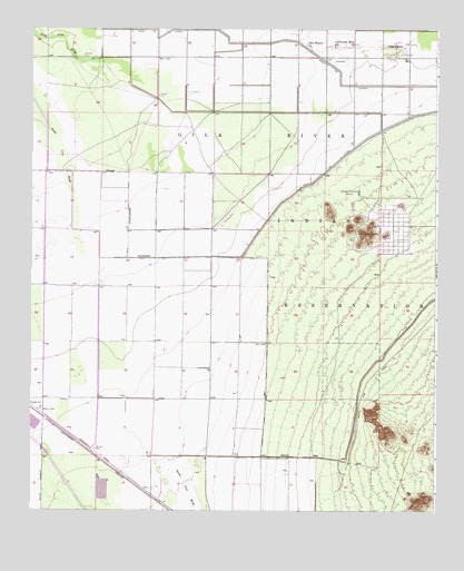
Sacaton Butte, AZ USGS Topographic Map
Click on map above to begin viewing in our Map Viewer.

This topographic map contains these locations and features:
Feature Name Type Latitude Longitude GNIS ID View Map
American Indian MissionChurchN33.1028°W111.9110°23646View Map
Camp Rivers (historical)LocaleN33.0723°W111.8865°23667View Map
Casa BlancaPopulated PlaceN33.1203°W111.8882°2499View Map
Casa Blanca Census Designated PlaceCensusN33.1154°W111.9081°2612137View Map
Casa Blanca ChurchChurchN33.1212°W111.9157°2501View Map
Casa Blanca Middle SchoolSchoolN33.1172°W111.8873°2545046View Map
Community Service Center and SchoolSchoolN33.1173°W111.8849°23678View Map
Culbertson Memorial ChurchChurchN33.1209°W111.9071°3637View Map
Desert Wind Middle SchoolSchoolN33.0501°W111.9500°2545030View Map
District 5CivilN33.0899°W111.8983°2418915View Map
Irah H Hayes High SchoolSchoolN33.1158°W111.8874°2545015View Map
KFAS-FM (Casa Grande)TowerN33.0059°W111.9818°45171View Map
Maricopa Police DepartmentBuildingN33.0460°W111.9937°2672258View Map
Papago GinLocaleN33.0267°W111.9974°9180View Map
Sacaton ButteSummitN33.0714°W111.8976°10624View Map
Santa Cruz Elementary SchoolSchoolN33.0596°W111.9551°2545029View Map
Santa Cruz WashArroyoN33.0139°W111.9560°23804View Map
Skyline District 5 SchoolSchoolN33.1164°W111.8846°2545014View Map
U of A Maricopa Ag Center AirportAirportN33.0741°W111.9826°45399View Map

Note: Coordinates in the location and feature list above are referenced to NAD83 datum.


Copyright (C) 2008-2025 Ryan Niemi / Sunset Dynamics ... All Rights Reserved