TopoQuest Logo
Do you find TopoQuest useful?
Help keep TopoQuest running and adding new maps/features by donating!
Bitcoin:  19c7KJd3qBynnjoSw5npx9KScwjBe4ifkT
Litecoin:  LXs6TkuXGGXo1vDsWCkWVdjQX94eUKd6ui
Home View Maps Find Maps Find Places Resources & Links


Gila Butte NW, Arizona Topographic Map

USGS Map Title: Gila Butte NW, AZ
USGS Map MRC: 33111B8
DRG (GeoTIFF) Download: o33111b8.tif


Neighboring USGS Topographic Map Quads:


  Lone Butte, AZ  
33112C1
 

  Guadalupe, AZ  
33111C8
 

  Chandler, AZ  
33111C7
 

  Pima Butte, AZ  
33112B1
 

  Gila Butte NW, AZ  
33111B8
 

  Gila Butte, AZ  
33111B7
 

  Maricopa, AZ  
33112A1
 

  Sacaton Butte, AZ  
33111A8
 

  Gila Butte SE, AZ  
33111A7


Map MRC Location:

N34°
W112°
N34°
W111°
H8 H7 H6 H5 H4 H3 H2 H1
G8 G7 G6 G5 G4 G3 G2 G1
F8 F7 F6 F5 F4 F3 F2 F1
E8 E7 E6 E5 E4 E3 E2 E1
D8 D7 D6 D5 D4 D3 D2 D1
C8 C7 C6 C5 C4 C3 C2 C1
B8 B7 B6 B5 B4 B3 B2 B1
A8 A7 A6 A5 A4 A3 A2 A1
N33°
W112°
N33°
W111°

Gila Butte NW, AZ USGS 1:24K Topographic Map Preview:
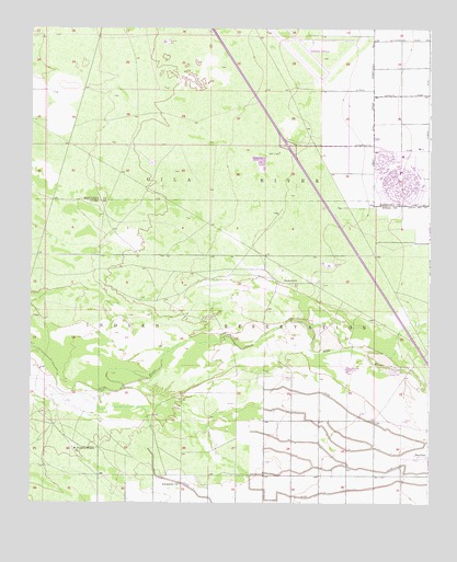
Gila Butte NW, AZ USGS Topographic Map
Click on map above to begin viewing in our Map Viewer.

This topographic map contains these locations and features:
Feature Name Type Latitude Longitude GNIS ID View Map
Adventist ChurchChurchN33.1301°W111.9532°23644View Map
Bapchule Community CenterBuildingN33.1373°W111.8790°23654View Map
First Baptist Church of Sun LakesChurchN33.2172°W111.8768°2670960View Map
Gila River Indian ReservationCivilN33.1542°W111.9272°23998View Map
Gila River Memorial AirportAirportN33.2446°W111.9097°45327View Map
Hohokam Pima National MonumentParkN33.1871°W111.9193°25440View Map
Interchange 167CrossingN33.2192°W111.9202°2466979View Map
Maricopa County Library District Ed Robson BranchBuildingN33.2183°W111.8817°2669424View Map
Sacate Village Census Designated PlaceCensusN33.1416°W111.9811°2612142View Map
Saint Francis Borgia ChurchChurchN33.1395°W111.9871°10703View Map
Saint Stevens Catholic ChurchChurchN33.2205°W111.8754°2671622View Map
SnaketownPopulated PlaceN33.1831°W111.9196°24621View Map
Sun LakesPopulated PlaceN33.2112°W111.8754°25113View Map
Sun Lakes Golf CourseLocaleN33.2139°W111.8846°43329View Map
Sun Lakes Mobile Home ParkPopulated PlaceN33.2092°W111.8843°2670518View Map
Sun Lakes Sheriff's PosseBuildingN33.2176°W111.8778°2751608View Map
Sun Lakes United Methodist ChurchChurchN33.2184°W111.8825°2671833View Map
United Church of Sun LakesChurchN33.2137°W111.8841°2671406View Map
Wet Camp Village Census Designated PlaceCensusN33.1414°W111.9005°2612149View Map

Note: Coordinates in the location and feature list above are referenced to NAD83 datum.


Copyright (C) 2008-2025 Ryan Niemi / Sunset Dynamics ... All Rights Reserved