TopoQuest Logo
Do you find TopoQuest useful?
Help keep TopoQuest running and adding new maps/features by donating!
Bitcoin:  19c7KJd3qBynnjoSw5npx9KScwjBe4ifkT
Litecoin:  LXs6TkuXGGXo1vDsWCkWVdjQX94eUKd6ui
Home View Maps Find Maps Find Places Resources & Links


Sadler, Texas Topographic Map

USGS Map Title: Sadler, TX
USGS Map MRC: 33096F7
DRG (GeoTIFF) Download: o33096f7.tif


Neighboring USGS Topographic Map Quads:


  Dexter, TX  
33096G8
 

  Gordonville, TX  
33096G7
 

  Pottsboro, TX  
33096G6
 

  Whitesboro, TX  
33096F8
 

  Sadler, TX  
33096F7
 

  Sherman NW, TX  
33096F6
 

  Collinsville, TX  
33096E8
 

  Ethel, TX  
33096E7
 

  Dorchester, TX  
33096E6


Map MRC Location:

N34°
W97°
N34°
W96°
H8 H7 H6 H5 H4 H3 H2 H1
G8 G7 G6 G5 G4 G3 G2 G1
F8 F7 F6 F5 F4 F3 F2 F1
E8 E7 E6 E5 E4 E3 E2 E1
D8 D7 D6 D5 D4 D3 D2 D1
C8 C7 C6 C5 C4 C3 C2 C1
B8 B7 B6 B5 B4 B3 B2 B1
A8 A7 A6 A5 A4 A3 A2 A1
N33°
W97°
N33°
W96°

Sadler, TX USGS 1:24K Topographic Map Preview:
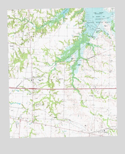
Sadler, TX USGS Topographic Map
Click on map above to begin viewing in our Map Viewer.

This topographic map contains these locations and features:
Feature Name Type Latitude Longitude GNIS ID View Map
Basin SpringsPopulated PlaceN33.7268°W96.8369°1379395View Map
Basin Springs CemeteryCemeteryN33.7234°W96.8442°1889650View Map
Beaver Creek AirportAirportN33.6543°W96.7765°2675912View Map
Bevoni-Flying B AirportAirportN33.7156°W96.8674°1387740View Map
Big Mineral CreekStreamN33.7251°W96.7792°1362945View Map
Big Mineral Public Use AreaParkN33.7206°W96.7767°1889652View Map
Christian Chapel CemeteryCemeteryN33.6807°W96.8169°1354475View Map
City of SadlerCivilN33.6821°W96.8487°2411752View Map
Deaver CreekStreamN33.7132°W96.7933°1372459View Map
Deaver PondLakeN33.7154°W96.7834°1889959View Map
Elba CreekStreamN33.6823°W96.8006°1356882View Map
Elm PondLakeN33.7248°W96.7603°1889653View Map
Frog Pond AirportAirportN33.6590°W96.7891°2717059View Map
GagePopulated PlaceN33.6751°W96.7581°1377143View Map
Graham FieldAirportN33.7045°W96.8312°1387444View Map
Hagerman National Wildlife RefugeParkN33.7338°W96.7802°1373973View Map
HangerPopulated PlaceN33.7112°W96.7578°1379884View Map
Harris CreekStreamN33.7376°W96.7536°1358850View Map
Hudgins Oil FieldOilfieldN33.6704°W96.7739°1889655View Map
Huff LakeReservoirN33.6589°W96.8671°1858296View Map
J P Huff DamDamN33.6584°W96.8636°1858295View Map
Kendall ChapelChurchN33.6646°W96.7783°1360569View Map
KTCY-FM (Denison)TowerN33.6751°W96.8614°1385837View Map
Margaritaville AirportAirportN33.7248°W96.8730°2675856View Map
Martin BranchStreamN33.7265°W96.7711°1362213View Map
MaydPopulated PlaceN33.6426°W96.8225°1377141View Map
Meadow PondLakeN33.7005°W96.8039°1889651View Map
Meadow Pond TrailTrailN33.6967°W96.8197°2033331View Map
Mulder Oil FieldOilfieldN33.7390°W96.8225°1377135View Map
Mustang CreekStreamN33.6973°W96.8203°1363547View Map
Old Goose PondLakeN33.7330°W96.7621°1889654View Map
Russell PondLakeN33.6950°W96.7952°1889998View Map
Saddler Oil FieldOilfieldN33.6568°W96.8392°1889649View Map
SadlerPopulated PlaceN33.6826°W96.8483°1367110View Map
Sadler CemeteryCemeteryN33.6679°W96.8486°1367112View Map
Sadler City HallBuildingN33.6846°W96.8483°2753596View Map
Sadler Post OfficePost OfficeN33.6833°W96.8486°2731645View Map
Sadler Volunteer Fire DepartmentBuildingN33.6831°W96.8478°2551732View Map
Sadler-Moulder Mineral Oil FieldOilfieldN33.7307°W96.8536°1375882View Map
SouthmaydPopulated PlaceN33.6304°W96.7692°1368840View Map
Southmayd City HallBuildingN33.6303°W96.7654°2753326View Map
Southmayd Police DepartmentBuildingN33.6305°W96.7660°2738959View Map
Southmayd Volunteer Fire DepartmentBuildingN33.6293°W96.7710°2551612View Map
SteedhamPopulated PlaceN33.6973°W96.7794°1377142View Map
Taylor PondLakeN33.7280°W96.7731°1369653View Map
ThornePopulated PlaceN33.6334°W96.7867°1380659View Map

Note: Coordinates in the location and feature list above are referenced to NAD83 datum.


Copyright (C) 2008-2025 Ryan Niemi / Sunset Dynamics ... All Rights Reserved