TopoQuest Logo
Do you find TopoQuest useful?
Help keep TopoQuest running and adding new maps/features by donating!
Bitcoin:  19c7KJd3qBynnjoSw5npx9KScwjBe4ifkT
Litecoin:  LXs6TkuXGGXo1vDsWCkWVdjQX94eUKd6ui
Home View Maps Find Maps Find Places Resources & Links


Saint Charles, Kentucky Topographic Map

USGS Map Title: Saint Charles, KY
USGS Map MRC: 37087B5
DRG (GeoTIFF) Download: o37087b5.tif


Neighboring USGS Topographic Map Quads:


  Coiltown, KY  
37087C6
 

  Madisonville West, KY  
37087C5
 

  Madisonville East, KY  
37087C4
 

  Dawson Springs, KY  
37087B6
 

  Saint Charles, KY  
37087B5
 

  Nortonville, KY  
37087B4
 

  Dawson Springs SW, KY  
37087A6
 

  Dawson Springs SE, KY  
37087A5
 

  Crofton, KY  
37087A4


Map MRC Location:

N38°
W88°
N38°
W87°
H8 H7 H6 H5 H4 H3 H2 H1
G8 G7 G6 G5 G4 G3 G2 G1
F8 F7 F6 F5 F4 F3 F2 F1
E8 E7 E6 E5 E4 E3 E2 E1
D8 D7 D6 D5 D4 D3 D2 D1
C8 C7 C6 C5 C4 C3 C2 C1
B8 B7 B6 B5 B4 B3 B2 B1
A8 A7 A6 A5 A4 A3 A2 A1
N37°
W88°
N37°
W87°

Saint Charles, KY USGS 1:24K Topographic Map Preview:
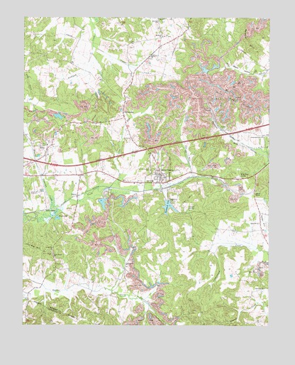
Saint Charles, KY USGS Topographic Map
Click on map above to begin viewing in our Map Viewer.

This topographic map contains these locations and features:
Feature Name Type Latitude Longitude GNIS ID View Map
Bald Duck SpringSpringN37.1867°W87.5144°486255View Map
Barnsley HillsRangeN37.2406°W87.5114°486422View Map
Beech HollowValleyN37.2265°W87.5048°486737View Map
Bunt Sisk HillsRangeN37.2184°W87.5219°488397View Map
Cane RunStreamN37.1812°W87.5806°488786View Map
Carrol SpringSpringN37.1728°W87.5411°488980View Map
Cat HillSummitN37.1762°W87.5408°489085View Map
Cedar HillSummitN37.1673°W87.5028°489214View Map
Cedar Hill ChurchChurchN37.1667°W87.5047°489220View Map
Christian Privilege CemeteryCemeteryN37.1880°W87.5605°489497View Map
City of Saint CharlesCivilN37.1881°W87.5510°2405391View Map
Copper CreekStreamN37.2381°W87.5894°490078View Map
Copperas CreekStreamN37.1681°W87.6183°490083View Map
Cranor ChurchChurchN37.1295°W87.5856°490296View Map
Crossroads Union ChurchChurchN37.2017°W87.5028°490403View Map
Daniel BoonePopulated PlaceN37.1787°W87.5075°507811View Map
Fox RunStreamN37.1859°W87.5389°492415View Map
Gamblin CemeteryCemeteryN37.2049°W87.5233°492664View Map
Gilliland ChurchChurchN37.1495°W87.5722°492847View Map
Good Hope (historical)Populated PlaceN37.1401°W87.5030°2743530View Map
Good Hope ChurchChurchN37.1403°W87.5022°492956View Map
Greenwood ChurchChurchN37.1556°W87.6094°493353View Map
HambyPopulated PlaceN37.1775°W87.5972°508166View Map
Hamby CemeteryCemeteryN37.1495°W87.6078°493610View Map
Homestead LakeReservoirN37.1735°W87.5511°494466View Map
IlsleyPopulated PlaceN37.1967°W87.6122°494887View Map
Ilsley Census Designated PlaceCensusN37.1996°W87.6144°2629635View Map
Ilsley SidingLocaleN37.1723°W87.6122°494888View Map
Lake Grove ChurchChurchN37.1753°W87.5492°495914View Map
Magic LakeLakeN37.1685°W87.6075°497452View Map
Saint CharlesPopulated PlaceN37.1862°W87.5558°502599View Map
Saint Charles DivisionCivilN37.1544°W87.5494°1937233View Map
Saint Charles Volunteer Fire DepartmentBuildingN37.1860°W87.5561°2636593View Map
SouthardPopulated PlaceN37.2386°W87.5556°2743545View Map
Southard CemeteryCemeteryN37.2485°W87.5562°503991View Map
Southard ChurchChurchN37.2342°W87.5606°503992View Map
Southard ChurchChurchN37.2423°W87.5547°503993View Map
Union Temple (historical)Populated PlaceN37.1526°W87.6091°2743547View Map
Union Temple CemeteryCemeteryN37.1542°W87.6100°505823View Map
Union Temple ChurchChurchN37.1534°W87.6092°505824View Map
WKMA-TV (Madisonville)TowerN37.1903°W87.5131°518060View Map

Note: Coordinates in the location and feature list above are referenced to NAD83 datum.


Copyright (C) 2008-2024 Ryan Niemi / Sunset Dynamics ... All Rights Reserved