TopoQuest Logo
Do you find TopoQuest useful?
Help keep TopoQuest running and adding new maps/features by donating!
Bitcoin:  19c7KJd3qBynnjoSw5npx9KScwjBe4ifkT
Litecoin:  LXs6TkuXGGXo1vDsWCkWVdjQX94eUKd6ui
Home View Maps Find Maps Find Places Resources & Links


Dawson Springs, Kentucky Topographic Map

USGS Map Title: Dawson Springs, KY
USGS Map MRC: 37087B6
DRG (GeoTIFF) Download: o37087b6.tif


Neighboring USGS Topographic Map Quads:


  Dalton, KY  
37087C7
 

  Coiltown, KY  
37087C6
 

  Madisonville West, KY  
37087C5
 

  Olney, KY  
37087B7
 

  Dawson Springs, KY  
37087B6
 

  Saint Charles, KY  
37087B5
 

  Princeton East, KY  
37087A7
 

  Dawson Springs SW, KY  
37087A6
 

  Dawson Springs SE, KY  
37087A5


Map MRC Location:

N38°
W88°
N38°
W87°
H8 H7 H6 H5 H4 H3 H2 H1
G8 G7 G6 G5 G4 G3 G2 G1
F8 F7 F6 F5 F4 F3 F2 F1
E8 E7 E6 E5 E4 E3 E2 E1
D8 D7 D6 D5 D4 D3 D2 D1
C8 C7 C6 C5 C4 C3 C2 C1
B8 B7 B6 B5 B4 B3 B2 B1
A8 A7 A6 A5 A4 A3 A2 A1
N37°
W88°
N37°
W87°

Dawson Springs, KY USGS 1:24K Topographic Map Preview:
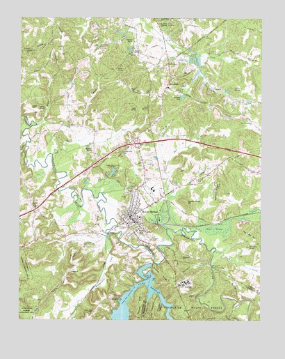
Dawson Springs, KY USGS Topographic Map
Click on map above to begin viewing in our Map Viewer.

This topographic map contains these locations and features:
Feature Name Type Latitude Longitude GNIS ID View Map
Allsbrook RidgeRidgeN37.1317°W87.6875°485890View Map
Ausenbaugh CemeteryCemeteryN37.1559°W87.7164°486145View Map
Beshear SpringSpringN37.1950°W87.7128°486921View Map
Blakely BendBendN37.1739°W87.7192°487446View Map
Blue Hole HollowValleyN37.1327°W87.6836°487520View Map
Buffalo CreekStreamN37.1537°W87.6486°488316View Map
Bull CreekStreamN37.1934°W87.7331°488349View Map
Caney CreekStreamN37.1624°W87.6638°488837View Map
Cap SpringSpringN37.2129°W87.6842°488912View Map
Chapel SpringSpringN37.2208°W87.6391°489343View Map
CharlestonPopulated PlaceN37.2248°W87.6720°489364View Map
Charleston Volunteer Fire DepartmentBuildingN37.2204°W87.6747°2636926View Map
City of Dawson SpringsCivilN37.1740°W87.6880°2404193View Map
Coatney RidgeRidgeN37.1434°W87.6767°489744View Map
Coats HillSummitN37.2128°W87.7447°489745View Map
Creekmur CemeteryCemeteryN37.1728°W87.7439°490319View Map
Dawson SpringsPopulated PlaceN37.1673°W87.6925°490696View Map
Dawson Springs DivisionCivilN37.2493°W87.7021°1936973View Map
Dawson Springs Police DepartmentBuildingN37.1669°W87.6936°2767454View Map
Dawson Springs Volunteer Fire DepartmentBuildingN37.1670°W87.6933°2636437View Map
Daylight LakeReservoirN37.2184°W87.6650°490705View Map
Dunn ChurchChurchN37.2042°W87.6842°491326View Map
Durrigan HollowValleyN37.1472°W87.6511°491354View Map
East Fork Bull CreekStreamN37.1962°W87.7281°491441View Map
East Fork Hurricane CreekStreamN37.1894°W87.6746°491466View Map
Fork SpringSpringN37.2297°W87.6985°492342View Map
Gibb SpringSpringN37.2123°W87.6901°492800View Map
Gobblers KnobSummitN37.1553°W87.6308°492927View Map
Howton SpringSpringN37.2408°W87.6921°494695View Map
Hurricane CreekStreamN37.1687°W87.6775°494821View Map
Lake BeshearReservoirN37.1399°W87.6876°486922View Map
LakeshorePopulated PlaceN37.1342°W87.6995°508419View Map
Lick ChurchChurchN37.2473°W87.6736°496463View Map
Lick Creek SpringSpringN37.2471°W87.6747°496489View Map
Maple SwampSwampN37.1639°W87.6437°497520View Map
McNeely CemeteryCemeteryN37.2155°W87.7240°497934View Map
Menser CemeteryCemeteryN37.1870°W87.6675°498066View Map
Montgomery CreekStreamN37.1609°W87.7022°498510View Map
Mount Hebron ChurchChurchN37.1450°W87.7239°498740View Map
Mount Pisgah Baptist ChurchChurchN37.1714°W87.7425°498816View Map
Murphy FordPopulated PlaceN37.1473°W87.6500°508663View Map
Nickson HillSummitN37.1509°W87.6658°499479View Map
North Fork Bull CreekStreamN37.1962°W87.7281°499543View Map
North Fork Hurricane CreekStreamN37.1894°W87.6746°499552View Map
Orange HillSummitN37.1528°W87.7225°499969View Map
Outwood HospitalHospitalN37.1383°W87.6652°500047View Map
Pat Alexander RidgeRidgeN37.1284°W87.6808°500232View Map
Penitentiary BendBendN37.1670°W87.6781°500376View Map
Piney Grove (historical)Populated PlaceN37.1285°W87.7114°2743604View Map
Piney Grove ChapelChurchN37.1284°W87.7114°500733View Map
Purdy HillSummitN37.1617°W87.6867°501464View Map
Rosedale CemeteryCemeteryN37.1833°W87.6841°502348View Map
Russell RidgeRidgeN37.1787°W87.6483°502529View Map
Section House HillSummitN37.1739°W87.6633°503150View Map
Sixseam (historical)Populated PlaceN37.1689°W87.6606°2743544View Map
Star of Bethlehem ChurchChurchN37.2075°W87.6300°504268View Map
The Big HillSummitN37.1572°W87.6256°505113View Map
Trace CreekStreamN37.2056°W87.7417°505420View Map
Tradewater AirportAirportN37.1887°W87.6755°517363View Map
Union Grove ChurchChurchN37.2053°W87.7253°505796View Map
University of Kentucky 4-H CampSchoolN37.1862°W87.7006°505847View Map
Walnut Grove (historical)Populated PlaceN37.1947°W87.6958°2743548View Map
Walnut Grove ChurchChurchN37.1948°W87.6967°506172View Map
Waterfall HollowValleyN37.1328°W87.6762°506262View Map
White SpringSpringN37.2132°W87.7376°506644View Map
Young SpringSpringN37.2357°W87.6882°507252View Map

Note: Coordinates in the location and feature list above are referenced to NAD83 datum.


Copyright (C) 2008-2024 Ryan Niemi / Sunset Dynamics ... All Rights Reserved