TopoQuest Logo
Do you find TopoQuest useful?
Help keep TopoQuest running and adding new maps/features by donating!
Bitcoin:  19c7KJd3qBynnjoSw5npx9KScwjBe4ifkT
Litecoin:  LXs6TkuXGGXo1vDsWCkWVdjQX94eUKd6ui
Home View Maps Find Maps Find Places Resources & Links


Saint Charles Bay, Texas Topographic Map

USGS Map Title: Saint Charles Bay, TX
USGS Map MRC: 28096B8
DRG (GeoTIFF) Download: o28096b8.tif


Neighboring USGS Topographic Map Quads:


  Tivoli SW, TX  
28096C8
 

  Tivoli SE, TX  
28096C7


  Saint Charles Bay, TX  
28096B8
 

  Mesquite Bay, TX  
28096B7


  Saint Charles Bay SW, TX  
28096A8
 

  Saint Charles Bay SE, TX  
28096A7


Map MRC Location:

N29°
W97°
N29°
W96°
H8 H7 H6 H5 H4 H3 H2 H1
G8 G7 G6 G5 G4 G3 G2 G1
F8 F7 F6 F5 F4 F3 F2 F1
E8 E7 E6 E5 E4 E3 E2 E1
D8 D7 D6 D5 D4 D3 D2 D1
C8 C7 C6 C5 C4 C3 C2 C1
B8 B7 B6 B5 B4 B3 B2 B1
A8 A7 A6 A5 A4 A3 A2 A1
N28°
W97°
N28°
W96°

Saint Charles Bay, TX USGS 1:24K Topographic Map Preview:
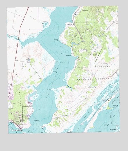
Saint Charles Bay, TX USGS Topographic Map
Click on map above to begin viewing in our Map Viewer.

This topographic map contains these locations and features:
Feature Name Type Latitude Longitude GNIS ID View Map
Acquillas WindmillLocaleN28.1420°W96.9347°1329190View Map
Alamos WindmillLocaleN28.2239°W96.8933°1329315View Map
Aransas National Wildlife Refuge TrailsystemTrailN28.2336°W96.9003°2032992View Map
Bartell IslandIslandN28.1250°W96.9758°1330103View Map
Bartell PassChannelN28.1250°W96.9786°1330104View Map
Big Devil BayouLakeN28.2132°W96.9240°1330589View Map
Big Sharp PointCapeN28.1964°W96.9455°1330649View Map
Bill Mott BayouLakeN28.1705°W96.9312°1330685View Map
Bird PointCapeN28.1314°W96.9622°1330701View Map
Black Jack PeninsulaCapeN28.2083°W96.8786°1330804View Map
Bludworth IslandIslandN28.1464°W96.8975°1330890View Map
Brahma WindmillLocaleN28.1700°W96.9089°1372703View Map
Cape CarlosCapeN28.1303°W96.9050°1332127View Map
Carlos BayBayN28.1370°W96.8878°1332162View Map
Cavasso CreekStreamN28.2147°W96.9833°1332348View Map
Cedar DugoutChannelN28.1506°W96.8780°1332423View Map
Cedar PointCapeN28.1483°W96.8842°1332467View Map
Cedar ReefBarN28.1375°W96.8842°1332475View Map
Dunham BayBayN28.1433°W96.9117°1334787View Map
East PocketBayN28.1272°W96.9617°1373557View Map
Egg PointCapeN28.1681°W96.9511°1335132View Map
Goose IslandIslandN28.1283°W96.9919°1336726View Map
Goose Island State ParkParkN28.1356°W96.9875°1336727View Map
Grass IslandIslandN28.1342°W96.9178°1381050View Map
Hail PointCapeN28.1336°W96.9753°1337222View Map
Helotes WindmillLocaleN28.1864°W96.9086°1337586View Map
Holiday Beach Volunteer Fire DepartmentBuildingN28.1693°W96.9979°2552296View Map
Indian Head PointCapeN28.2022°W96.9269°1338429View Map
Kalt Ranch AirportAirportN28.1545°W96.9769°1386703View Map
La Punta WindmillLocaleN28.1389°W96.9497°1339391View Map
Lamar CemeteryCemeteryN28.1431°W96.9892°1339562View Map
Lamar Census Designated PlaceCensusN28.1400°W96.9891°2586949View Map
Lamar PeninsulaCapeN28.1636°W96.9855°1339570View Map
Lamar Volunteer Fire DepartmentBuildingN28.1429°W96.9887°2552344View Map
Lampasas LakeSwampN28.2475°W96.9125°1339594View Map
Little Devil BayouBayN28.2006°W96.9208°1340078View Map
Little Sharp PointCapeN28.1858°W96.9500°1340189View Map
McHugh BayouGutN28.2339°W96.9255°1341220View Map
McHugh WindmillLocaleN28.2328°W96.9269°1341221View Map
Meile Dietrich PointCapeN28.2175°W96.9411°1341344View Map
Neptune HarborHarborN28.1303°W96.9867°1381049View Map
Ratama WindmillLocaleN28.1925°W96.8878°1344804View Map
Saint Charles BayBayN28.2000°W96.9389°1345882View Map
Saint Charles WindmillLocaleN28.2428°W96.9225°1345883View Map
Star of the Sea ChapelChurchN28.1358°W96.9933°1347806View Map

Note: Coordinates in the location and feature list above are referenced to NAD83 datum.


Copyright (C) 2008-2024 Ryan Niemi / Sunset Dynamics ... All Rights Reserved