TopoQuest Logo
Do you find TopoQuest useful?
Help keep TopoQuest running and adding new maps/features by donating!
Bitcoin:  19c7KJd3qBynnjoSw5npx9KScwjBe4ifkT
Litecoin:  LXs6TkuXGGXo1vDsWCkWVdjQX94eUKd6ui
Home View Maps Find Maps Find Places Resources & Links


Saint Charles Bay SW, Texas Topographic Map

USGS Map Title: Saint Charles Bay SW, TX
USGS Map MRC: 28096A8
DRG (GeoTIFF) Download: o28096a8.tif


Neighboring USGS Topographic Map Quads:


  Saint Charles Bay, TX  
28096B8
 

  Mesquite Bay, TX  
28096B7


  Saint Charles Bay SW, TX  
28096A8
 

  Saint Charles Bay SE, TX  
28096A7
 

  Estes, TX  
27097H1
 

  Allyns Bight, TX  
27096H8


Map MRC Location:

N29°
W97°
N29°
W96°
H8 H7 H6 H5 H4 H3 H2 H1
G8 G7 G6 G5 G4 G3 G2 G1
F8 F7 F6 F5 F4 F3 F2 F1
E8 E7 E6 E5 E4 E3 E2 E1
D8 D7 D6 D5 D4 D3 D2 D1
C8 C7 C6 C5 C4 C3 C2 C1
B8 B7 B6 B5 B4 B3 B2 B1
A8 A7 A6 A5 A4 A3 A2 A1
N28°
W97°
N28°
W96°

Saint Charles Bay SW, TX USGS 1:24K Topographic Map Preview:
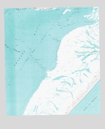
Saint Charles Bay SW, TX USGS Topographic Map
Click on map above to begin viewing in our Map Viewer.

This topographic map contains these locations and features:
Feature Name Type Latitude Longitude GNIS ID View Map
Aransas BayBayN28.0503°W96.9917°1329648View Map
Aransas CountyCivilN28.0847°W96.9914°1383789View Map
Ballou IslandIslandN28.1211°W96.8758°1381125View Map
Big IslandIslandN28.0522°W96.9439°1381033View Map
Big IslandIslandN28.0522°W96.9439°1381036View Map
Blackjack PeninsulaCapeN28.1245°W96.9461°1330803View Map
Blackjack PointCapeN28.1239°W96.9619°1330805View Map
Cape Carlos DugoutChannelN28.1189°W96.9047°1332128View Map
Deadman IslandIslandN28.0650°W96.9611°1334151View Map
Dunham IslandIslandN28.1225°W96.9169°1334788View Map
Dunham PointCapeN28.1242°W96.9319°1334789View Map
Fulton DivisionCivilN28.1047°W96.9610°1938761View Map
Jay Bird PointCapeN28.0864°W96.9255°1338675View Map
Jay Bird ReefBarN28.0878°W96.9342°1338676View Map
Long ReefBarN28.0586°W96.9561°1340511View Map
Mack ReefBarN28.0883°W96.9811°1381034View Map
Pauls MottWoodsN28.0450°W96.9439°1381039View Map
Pauls Mott ReefBarN28.0478°W96.9480°1381038View Map
Pelican ReefBarN28.1072°W96.9303°1343811View Map
Poverty ReefBarN28.1039°W96.9278°1344447View Map
San Jose IslandIslandN28.0003°W96.9336°1346384View Map
Shell ReefBarN28.0770°W96.9942°1337239View Map
Spalding BightBayN28.1083°W96.8905°1347621View Map
Spalding ReefBarN28.1045°W96.9119°1347622View Map
Thompsons TowheadsBarN28.1061°W96.9533°1381035View Map
Towhead ReefBarN28.1106°W96.9369°1381048View Map
Vinson SloughLakeN28.0736°W96.8794°1349299View Map

Note: Coordinates in the location and feature list above are referenced to NAD83 datum.


Copyright (C) 2008-2025 Ryan Niemi / Sunset Dynamics ... All Rights Reserved