TopoQuest Logo
Do you find TopoQuest useful?
Help keep TopoQuest running and adding new maps/features by donating!
Bitcoin:  19c7KJd3qBynnjoSw5npx9KScwjBe4ifkT
Litecoin:  LXs6TkuXGGXo1vDsWCkWVdjQX94eUKd6ui
Home View Maps Find Maps Find Places Resources & Links


Saint Clements Island, Maryland Topographic Map

USGS Map Title: Saint Clements Island, MD
USGS Map MRC: 38076B6
DRG (GeoTIFF) Download: o38076b6.tif


Neighboring USGS Topographic Map Quads:


  Rock Point, MD  
38076C7
 

  Leonardtown, MD  
38076C6
 

  Hollywood, MD  
38076C5
 

  Stratford Hall, VA  
38076B7
 

  Saint Clements Island, MD  
38076B6
 

  Piney Point, MD  
38076B5
 

  Montross, VA  
38076A7
 

  Machodoc, VA  
38076A6
 

  Kinsale, VA  
38076A5


Map MRC Location:

N39°
W77°
N39°
W76°
H8 H7 H6 H5 H4 H3 H2 H1
G8 G7 G6 G5 G4 G3 G2 G1
F8 F7 F6 F5 F4 F3 F2 F1
E8 E7 E6 E5 E4 E3 E2 E1
D8 D7 D6 D5 D4 D3 D2 D1
C8 C7 C6 C5 C4 C3 C2 C1
B8 B7 B6 B5 B4 B3 B2 B1
A8 A7 A6 A5 A4 A3 A2 A1
N38°
W77°
N38°
W76°

Saint Clements Island, MD USGS 1:24K Topographic Map Preview:
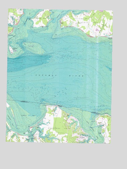
Saint Clements Island, MD USGS Topographic Map
Click on map above to begin viewing in our Map Viewer.

This topographic map contains these locations and features:
Feature Name Type Latitude Longitude GNIS ID View Map
Aimes CreekStreamN38.1271°W76.6530°1462380View Map
Back CreekBayN38.2393°W76.7425°594576View Map
Beatley PointCapeN38.1354°W76.6366°1791370View Map
Bedlam NeckCapeN38.2307°W76.7483°1697477View Map
Bettys PondLakeN38.1501°W76.6747°1463260View Map
BloomsburyLocaleN38.2287°W76.6302°1697479View Map
Blue SowBarN38.2340°W76.7072°594597View Map
Branson CoveBayN38.1418°W76.6361°1463771View Map
Breton BeachPopulated PlaceN38.2374°W76.6869°594603View Map
Buckner CreekStreamN38.1335°W76.7189°1464018View Map
Bushfield Golf CourseLocaleN38.1269°W76.7072°2520146View Map
Cabin PointCapeN38.1465°W76.6641°1464228View Map
Cabin Point CreekStreamN38.1382°W76.6591°1464230View Map
Cedar IslandIslandN38.1332°W76.7252°1464628View Map
Clem PointCapeN38.2474°W76.6980°594663View Map
Coles PointCapeN38.1526°W76.6297°1465103View Map
Coles PointPopulated PlaceN38.1437°W76.6355°1499282View Map
Coles Point Post OfficePost OfficeN38.1429°W76.6374°1877525View Map
Cornish PointCapeN38.2337°W76.7191°594682View Map
Danger PointCapeN38.1274°W76.6447°1465590View Map
Deerfield AirportAirportN38.2384°W76.6602°598344View Map
Dukeharts ChannelChannelN38.2207°W76.7500°594697View Map
Elbow PointCapeN38.1374°W76.7377°1466204View Map
Flood CreekStreamN38.2249°W76.6280°594709View Map
Fresh PondLakeN38.2418°W76.7008°594717View Map
Glebe CreekStreamN38.1301°W76.6472°1467142View Map
Glebe HarborLocaleN38.1293°W76.6594°1467144View Map
Glebe PointCapeN38.1285°W76.6430°1467148View Map
Grannys BarSwampN38.1341°W76.6349°1467351View Map
Grapevine PointCapeN38.1460°W76.6433°1467356View Map
Hampton AirportAirportN38.2299°W76.6285°598346View Map
Heron Island (historical)IslandN38.2154°W76.7219°1697546View Map
Heron Island BarBarN38.2160°W76.7244°594744View Map
Herring PondLakeN38.1567°W76.6912°1467960View Map
Huggins PointCapeN38.2332°W76.6861°594760View Map
Icehouse PointCapeN38.1318°W76.7166°1468446View Map
Kaywood PointCapeN38.2346°W76.7050°594780View Map
Kilmarnock-Lancaster Volunteer Rescue SquadBuildingN38.1736°W76.6517°2086205View Map
Kingcopsico PointCapeN38.1596°W76.7016°1469013View Map
Linton PointCapeN38.1315°W76.6511°1469448View Map
Long PointCapeN38.2410°W76.7219°594802View Map
Lower Machodoc CreekStreamN38.1471°W76.6533°1469915View Map
Machodoc NeckCapeN38.1387°W76.6830°1469990View Map
Matthews CoveBayN38.1274°W76.7233°1470195View Map
Matthews PointCapeN38.1310°W76.7230°1470197View Map
Medleys CreekStreamN38.2249°W76.6452°594823View Map
Medleys NeckCapeN38.2390°W76.6519°594824View Map
MeterPopulated PlaceN38.1254°W76.6333°1499734View Map
Newtown NeckCapeN38.2454°W76.7080°594847View Map
Newtown Neck Proving Ground (historical)LocaleN38.2382°W76.7108°1697606View Map
Nomini BayBayN38.1499°W76.7225°1471558View Map
Nomini CreekStreamN38.1368°W76.7250°1471561View Map
North Prong Buckner CreekStreamN38.1371°W76.7125°1471634View Map
Nuns OakLocaleN38.2418°W76.6647°1697609View Map
Orchard CoveBayN38.1290°W76.7150°1791443View Map
Payne PointCapeN38.2412°W76.6989°594868View Map
Poor Jack CreekStreamN38.1368°W76.7441°1472608View Map
Port Sunlight BeachBeachN38.2312°W76.7441°1697623View Map
Poseys BluffCliffN38.2262°W76.6516°594888View Map
Protestant PointCapeN38.2482°W76.6744°594892View Map
Raccoon CoveBayN38.1285°W76.7033°1791451View Map
Ridge Volunteer Rescue Squad Company 49BuildingN38.2036°W76.6253°2086975View Map
Saint Celments BayBayN38.2432°W76.7275°594564View Map
Saint Clements BayBayN38.2335°W76.7330°595026View Map
Saint Clements IslandIslandN38.2112°W76.7455°594914View Map
Saint Clements Island Lighthouse (historical)LocaleN38.2132°W76.7327°1697638View Map
Saint Clements Island-Potomac River MuseumBuildingN38.2254°W76.7500°1697639View Map
Saint Patrick CreekStreamN38.2326°W76.7405°594946View Map
Sandyland BeachBeachN38.2149°W76.6619°1697659View Map
Sandyland BeachPopulated PlaceN38.2307°W76.6575°598320View Map
Shipping PointCapeN38.2460°W76.7322°1697666View Map
Smarts CreekStreamN38.1321°W76.7350°1474712View Map
Snake IslandIslandN38.1382°W76.7133°1474799View Map
Stone CrossPillarN38.2087°W76.7447°594971View Map
Stony BarBarN38.1518°W76.6386°1475201View Map
Trent IslandIslandN38.1307°W76.6463°1791469View Map
Weatherall CreekStreamN38.1271°W76.6425°1476410View Map
White Oak PointCapeN38.1276°W76.7164°1476614View Map
White PointCapeN38.1343°W76.7194°1476630View Map

Note: Coordinates in the location and feature list above are referenced to NAD83 datum.


Copyright (C) 2008-2024 Ryan Niemi / Sunset Dynamics ... All Rights Reserved