TopoQuest Logo
Do you find TopoQuest useful?
Help keep TopoQuest running and adding new maps/features by donating!
Bitcoin:  19c7KJd3qBynnjoSw5npx9KScwjBe4ifkT
Litecoin:  LXs6TkuXGGXo1vDsWCkWVdjQX94eUKd6ui
Home View Maps Find Maps Find Places Resources & Links


Rock Point, Maryland Topographic Map

USGS Map Title: Rock Point, MD
USGS Map MRC: 38076C7
DRG (GeoTIFF) Download: o38076c7.tif


Neighboring USGS Topographic Map Quads:


  Popes Creek, MD  
38076D8
 

  Charlotte Hall, MD  
38076D7
 

  Mechanicsville, MD  
38076D6
 

  Colonial Beach North, VA  
38076C8
 

  Rock Point, MD  
38076C7
 

  Leonardtown, MD  
38076C6
 

  Colonial Beach South, VA  
38076B8
 

  Stratford Hall, VA  
38076B7
 

  Saint Clements Island, MD  
38076B6


Map MRC Location:

N39°
W77°
N39°
W76°
H8 H7 H6 H5 H4 H3 H2 H1
G8 G7 G6 G5 G4 G3 G2 G1
F8 F7 F6 F5 F4 F3 F2 F1
E8 E7 E6 E5 E4 E3 E2 E1
D8 D7 D6 D5 D4 D3 D2 D1
C8 C7 C6 C5 C4 C3 C2 C1
B8 B7 B6 B5 B4 B3 B2 B1
A8 A7 A6 A5 A4 A3 A2 A1
N38°
W77°
N38°
W76°

Rock Point, MD USGS 1:24K Topographic Map Preview:
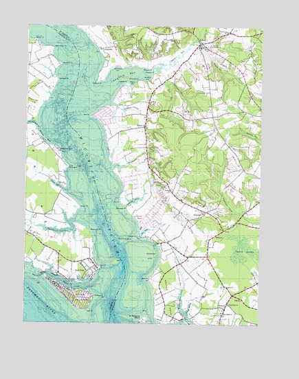
Rock Point, MD USGS Topographic Map
Click on map above to begin viewing in our Map Viewer.

This topographic map contains these locations and features:
Feature Name Type Latitude Longitude GNIS ID View Map
Abell SchoolSchoolN38.2604°W76.7589°594567View Map
Anglican Chapel (historical)ChurchN38.2729°W76.7939°1697300View Map
AvenuePopulated PlaceN38.2562°W76.7677°594574View Map
Avenue BranchBayN38.2568°W76.7866°594575View Map
Avenue Post OfficePost OfficeN38.2600°W76.7665°1697301View Map
Bachelors HopeLocaleN38.3379°W76.7939°1697302View Map
Bankhead CoveBayN38.3532°W76.8108°594579View Map
Bankhead PointCapeN38.3521°W76.8152°594580View Map
Barber PointCapeN38.3687°W76.8705°583020View Map
Barbers QuarterPopulated PlaceN38.3746°W76.8408°1697303View Map
Basford ManorLocaleN38.3493°W76.8147°1697305View Map
Bassfold CreekStreamN38.3421°W76.8294°594583View Map
Bethune Elementary SchoolSchoolN38.2915°W76.7666°1697307View Map
Blairs PurchaseLocaleN38.2940°W76.7877°1697312View Map
BlakistonePopulated PlaceN38.2840°W76.8022°1697313View Map
BloomfieldLocaleN38.2765°W76.7822°1697315View Map
Bluff PointCapeN38.2687°W76.8072°594598View Map
Bramleigh CreekBayN38.3018°W76.8164°594599View Map
Bramleigh PointCapeN38.2985°W76.8197°594600View Map
Bull RunPopulated PlaceN38.3379°W76.7914°594612View Map
Bull RunStreamN38.3521°W76.8000°594613View Map
Burroughs RunStreamN38.3554°W76.8033°594616View Map
BushwoodPopulated PlaceN38.2965°W76.7791°594617View Map
Bushwood CoveBayN38.2787°W76.8075°594618View Map
Bushwood Lodge (historical)BuildingN38.3132°W76.7655°1697324View Map
Bushwood Manor House (historical)BuildingN38.2982°W76.7927°1697325View Map
Bushwood Post OfficePost OfficeN38.2966°W76.7793°1697326View Map
Bushwood WharfPopulated PlaceN38.2840°W76.8019°595028View Map
Camp Saint CharlesLocaleN38.2912°W76.8477°1676983View Map
Cannons Old Field BarBarN38.3140°W76.8294°1697327View Map
ChapticoPopulated PlaceN38.3676°W76.7830°594644View Map
Chaptico BayBayN38.3546°W76.8222°594645View Map
Chaptico CreekStreamN38.3660°W76.7877°594561View Map
Chaptico PointCapeN38.3554°W76.8064°594646View Map
Chaptico Post OfficePost OfficeN38.3685°W76.7828°1697332View Map
Chaptico RunStreamN38.3565°W76.8072°594647View Map
Chaptico WharfLocaleN38.3271°W76.8327°1697333View Map
Charleston CreekBayN38.2885°W76.8561°583703View Map
Charleston CreekPopulated PlaceN38.2854°W76.8511°1676995View Map
Christ ChurchChurchN38.3660°W76.7833°594656View Map
Christ Church CemeteryCemeteryN38.3658°W76.7835°1697338View Map
Church SwampSwampN38.2815°W76.7588°594660View Map
Clover Dale AcresPopulated PlaceN38.3465°W76.7586°1697469View Map
Cobb BarBarN38.2529°W76.8405°1677000View Map
Cobb IslandIslandN38.2607°W76.8439°588757View Map
Cobb IslandPopulated PlaceN38.2585°W76.8439°1988529View Map
Cobb Island Census Designated PlaceCensusN38.2646°W76.8495°2583600View Map
Cobb Island Post OfficePost OfficeN38.2641°W76.8500°1677001View Map
Cobb Island Volunteer Fire Department and Emergency Medical ServicesBuildingN38.2624°W76.8510°2087271View Map
Cobb PointCapeN38.2554°W76.8416°588759View Map
Coffee Hill RunStreamN38.3698°W76.7847°594669View Map
Cohouck PointCapeN38.3515°W76.8375°594670View Map
Deep Falls (historical)LocaleN38.3521°W76.7539°1697344View Map
Denby HillPopulated PlaceN38.2882°W76.7758°1697345View Map
District 4, ChapticoCivilN38.3701°W76.7831°1929606View Map
Dolly Boarmans CreekStreamN38.3323°W76.8686°584124View Map
Dynard Elementary SchoolSchoolN38.3137°W76.7590°1697347View Map
Elm BarBarN38.3707°W76.8447°1697349View Map
Fennell PointCapeN38.2990°W76.8458°584357View Map
Fenwick SchoolSchoolN38.3060°W76.7964°594705View Map
Fosters NeckLocaleN38.2537°W76.8041°1697357View Map
Gravelly HillsPopulated PlaceN38.3737°W76.8216°1697360View Map
Green SpringsLocaleN38.3310°W76.8133°1697362View Map
Hatchs ThicketLocaleN38.2557°W76.7608°1697363View Map
Hatton CreekBayN38.3082°W76.8589°584898View Map
Hayden CoveBayN38.3512°W76.8186°594739View Map
Hayden PointCapeN38.3507°W76.8216°594740View Map
Holy Angels ChurchChurchN38.2549°W76.7694°594754View Map
Holy Angels SchoolSchoolN38.2550°W76.7694°1697369View Map
HurryPopulated PlaceN38.3371°W76.7755°594762View Map
Hurry Post Office (historical)Post OfficeN38.3371°W76.7761°1697372View Map
IndiantownPopulated PlaceN38.3651°W76.8347°594764View Map
Indiantown CoveBayN38.3565°W76.8266°594765View Map
Indiantown RunStreamN38.3582°W76.8197°594766View Map
Keys BarBarN38.3640°W76.8400°1697376View Map
Lancaster BarBarN38.2787°W76.8258°1677065View Map
Lancaster WharfLocaleN38.2729°W76.8347°1677066View Map
Longview BeachPopulated PlaceN38.2935°W76.8077°594804View Map
LoretanoLocaleN38.3723°W76.7872°1697383View Map
Lower Brambley (historical)Populated PlaceN38.3010°W76.8108°1697385View Map
MaddoxPopulated PlaceN38.3326°W76.8116°594812View Map
Maddox CreekStreamN38.3429°W76.8658°585652View Map
Maddox Post OfficePost OfficeN38.3298°W76.8122°1697386View Map
Maiden BowerLocaleN38.2749°W76.7816°1697387View Map
Manahowic CreekStreamN38.3157°W76.8277°594814View Map
Mattapany PlantationLocaleN38.2710°W76.7886°1697389View Map
Mattney PointCapeN38.3576°W76.8094°594818View Map
MilestownPopulated PlaceN38.2874°W76.7736°594827View Map
Mill CreekBayN38.2887°W76.8108°594829View Map
Mill Point (historical)LocaleN38.3371°W76.8391°1697395View Map
Mill Point BarBarN38.3362°W76.8455°1697396View Map
Mill Point ShoresPopulated PlaceN38.3371°W76.8330°1697397View Map
Mills PointCapeN38.3371°W76.8397°594832View Map
Mouth of River BarBarN38.2529°W76.8177°1697403View Map
Neale SoundBayN38.2687°W76.8583°586152View Map
Neale Sound ChannelChannelN38.2707°W76.8661°586153View Map
Neales HillLocaleN38.3401°W76.8102°1697404View Map
Nelsons RunStreamN38.3646°W76.7816°594844View Map
Notley HallLocaleN38.3148°W76.8064°1697407View Map
Nyce Airport (historical)AirportN38.3507°W76.8633°595323View Map
Ocean HallLocaleN38.2882°W76.8014°1697412View Map
Old Roots BarBarN38.2624°W76.8158°1697413View Map
Old Wharf LandingLocaleN38.2540°W76.7891°1697414View Map
Our Lady of the Wayside ChurchChurchN38.3671°W76.7772°594858View Map
Our Ladys ManorLocaleN38.2887°W76.8461°1677107View Map
PenerineLocaleN38.2779°W76.7772°1697418View Map
Persimmon PointCapeN38.2887°W76.8402°586482View Map
Pirates Den MarinaLocaleN38.2638°W76.8475°2503571View Map
Pon PointCapeN38.3010°W76.8236°594885View Map
Pond Point BarBarN38.3029°W76.8289°1697420View Map
RidgewoodPopulated PlaceN38.3398°W76.7594°1697425View Map
Rock PointCapeN38.2735°W76.8344°586881View Map
Rock PointPopulated PlaceN38.2721°W76.8408°591157View Map
Rock Point Census Designated PlaceCensusN38.2755°W76.8428°2583683View Map
Rock Point Post OfficePost OfficeN38.2735°W76.8361°1677128View Map
Russell LandingLocaleN38.3176°W76.8291°1697429View Map
Sacred Heart Catholic ChurchChurchN38.3026°W76.7922°1697431View Map
Sacred Heart ChurchChurchN38.2582°W76.7664°594906View Map
Sacred Heart Parochial SchoolSchoolN38.3024°W76.7919°1697432View Map
Saint CatherinePopulated PlaceN38.2526°W76.7983°1697433View Map
Saint Margaret IslandIslandN38.2515°W76.8105°594939View Map
SavonaLocaleN38.3698°W76.8027°1697441View Map
Second District Volunteer Company and Rescue Squad 6BuildingN38.3189°W76.8536°2086978View Map
Seventh District Community ParkParkN38.2932°W76.7666°1697442View Map
Seventh District Volunteer Fire Department Company 5BuildingN38.2631°W76.7645°2086976View Map
Seventh District Volunteer Rescue SquadBuildingN38.2598°W76.7656°2131795View Map
Shipping PointCapeN38.2618°W76.8380°587345View Map
South Hampton (historical)LocaleN38.3648°W76.7794°1697448View Map
Squier LandingAirportN38.2881°W76.8685°595260View Map
Stoddard PointCapeN38.3590°W76.8569°587568View Map
Stoddert BarBarN38.3587°W76.8550°1677152View Map
Tennyson PointCapeN38.3523°W76.8589°587721View Map
The GlebeLocaleN38.3015°W76.7827°1697454View Map
Upper Brambley (historical)Populated PlaceN38.3021°W76.8102°1697459View Map
West HattonPopulated PlaceN38.3626°W76.8627°1677181View Map
West Hatton PointCapeN38.3654°W76.8616°588147View Map
White PointCapeN38.2868°W76.8139°595011View Map
White Point BarBarN38.2854°W76.8180°598318View Map
White Point IslandIslandN38.2849°W76.8194°595013View Map
Whites NeckCapeN38.2615°W76.7977°595014View Map
Whites Neck CreekStreamN38.2515°W76.7897°595015View Map
Whites Neck PointCapeN38.2501°W76.7997°595016View Map
Wicomico BeachBeachN38.3271°W76.8661°588232View Map
Wicomico RiverStreamN38.2518°W76.8255°595017View Map
Willow GlenLocaleN38.3223°W76.8247°1697467View Map
Windmill PointCapeN38.3160°W76.8522°588290View Map
Woodberry BeachPopulated PlaceN38.3229°W76.8577°591585View Map
Yellow BankPopulated PlaceN38.2607°W76.8008°1697460View Map

Note: Coordinates in the location and feature list above are referenced to NAD83 datum.


Copyright (C) 2008-2024 Ryan Niemi / Sunset Dynamics ... All Rights Reserved