TopoQuest Logo
Do you find TopoQuest useful?
Help keep TopoQuest running and adding new maps/features by donating!
Bitcoin:  19c7KJd3qBynnjoSw5npx9KScwjBe4ifkT
Litecoin:  LXs6TkuXGGXo1vDsWCkWVdjQX94eUKd6ui
Home View Maps Find Maps Find Places Resources & Links


Saint John, Maine Topographic Map

USGS Map Title: Saint John, ME
USGS Map MRC: 47068B7
DRG (GeoTIFF) Download: o47068b7.tif


Neighboring USGS Topographic Map Quads:


  Saint Francis, ME  
47068B8
 

  Saint John, ME  
47068B7
 

  Wheelock, ME  
47068B6
 

  Pelletier Brook Lakes, ME  
47068A8
 

  McLean Mountain, ME  
47068A7
 

  Wallagrass Lakes, ME  
47068A6


Map MRC Location:

N48°
W69°
N48°
W68°
H8 H7 H6 H5 H4 H3 H2 H1
G8 G7 G6 G5 G4 G3 G2 G1
F8 F7 F6 F5 F4 F3 F2 F1
E8 E7 E6 E5 E4 E3 E2 E1
D8 D7 D6 D5 D4 D3 D2 D1
C8 C7 C6 C5 C4 C3 C2 C1
B8 B7 B6 B5 B4 B3 B2 B1
A8 A7 A6 A5 A4 A3 A2 A1
N47°
W69°
N47°
W68°

Saint John, ME USGS 1:24K Topographic Map Preview:
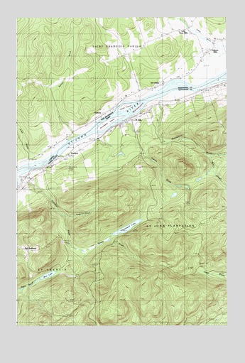
Saint John, ME USGS Topographic Map
Click on map above to begin viewing in our Map Viewer.

This topographic map contains these locations and features:
Feature Name Type Latitude Longitude GNIS ID View Map
Back SettlementPopulated PlaceN47.1564°W68.8700°579116View Map
BradburyPopulated PlaceN47.1945°W68.8439°562842View Map
Bran LakeLakeN47.1453°W68.8569°562883View Map
Caton IslandIslandN47.2145°W68.8100°563700View Map
Factory BrookStreamN47.2078°W68.8139°565982View Map
Harding SchoolSchoolN47.2156°W68.7784°567606View Map
Hunnewell IslandIslandN47.2059°W68.8217°568459View Map
Hunnewell LakeReservoirN47.1646°W68.8094°568457View Map
Hunnewell Lake DamDamN47.1616°W68.8189°1774426View Map
Jones BrookStreamN47.1692°W68.8450°568952View Map
Jones BrookStreamN47.1692°W68.8453°568953View Map
Kelly BrookStreamN47.2039°W68.8237°569075View Map
Plantation of Saint JohnCivilN47.1644°W68.7590°582710View Map
Saint Charles CemeteryCemeteryN47.1845°W68.8688°2678662View Map
Saint JohnPopulated PlaceN47.2084°W68.8073°574719View Map
Saint John Baptist Church CemeteryCemeteryN47.2081°W68.8105°2678688View Map
Saint John Catholic CemeteryCemeteryN47.2202°W68.7641°2678384View Map
Saint John ChurchChurchN47.2200°W68.7639°574721View Map
Thibideau BrookStreamN47.1889°W68.8664°576944View Map
West Branch Wheelock BrookStreamN47.1936°W68.7609°578103View Map
Wheelock BrookStreamN47.2175°W68.7903°578315View Map
Wheelock IslandIslandN47.2134°W68.8034°578316View Map

Note: Coordinates in the location and feature list above are referenced to NAD83 datum.


Copyright (C) 2008-2025 Ryan Niemi / Sunset Dynamics ... All Rights Reserved