TopoQuest Logo
Do you find TopoQuest useful?
Help keep TopoQuest running and adding new maps/features by donating!
Bitcoin:  19c7KJd3qBynnjoSw5npx9KScwjBe4ifkT
Litecoin:  LXs6TkuXGGXo1vDsWCkWVdjQX94eUKd6ui
Home View Maps Find Maps Find Places Resources & Links


Saint Joseph South, Missouri Topographic Map

USGS Map Title: Saint Joseph South, MO
USGS Map MRC: 39094F7
DRG (GeoTIFF) Download: o39094f7.tif


Neighboring USGS Topographic Map Quads:


  Wathena, KS  
39094G8
 

  Saint Joseph North, MO  
39094G7
 

  Cosby, MO  
39094G6
 

  Halls, MO  
39094F8
 

  Saint Joseph South, MO  
39094F7
 

  Agency, MO  
39094F6
 

  De Kalb, MO  
39094E8
 

  Dearborn, MO  
39094E7
 

  Edgerton, MO  
39094E6


Map MRC Location:

N40°
W95°
N40°
W94°
H8 H7 H6 H5 H4 H3 H2 H1
G8 G7 G6 G5 G4 G3 G2 G1
F8 F7 F6 F5 F4 F3 F2 F1
E8 E7 E6 E5 E4 E3 E2 E1
D8 D7 D6 D5 D4 D3 D2 D1
C8 C7 C6 C5 C4 C3 C2 C1
B8 B7 B6 B5 B4 B3 B2 B1
A8 A7 A6 A5 A4 A3 A2 A1
N39°
W95°
N39°
W94°

Saint Joseph South, MO USGS 1:24K Topographic Map Preview:
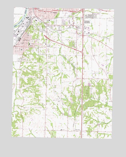
Saint Joseph South, MO USGS Topographic Map
Click on map above to begin viewing in our Map Viewer.

This topographic map contains these locations and features:
Feature Name Type Latitude Longitude GNIS ID View Map
Agency ChurchChurchN39.6608°W94.7502°713171View Map
Ajax (historical)LocaleN39.7039°W94.8122°746516View Map
Ashton (historical)Populated PlaceN39.7219°W94.8344°739510View Map
Bee CreekLocaleN39.6625°W94.7925°739976View Map
Benton High SchoolSchoolN39.7149°W94.8546°713974View Map
Buchanan CountyCivilN39.6599°W94.8062°758465View Map
Butch's StripAirportN39.7072°W94.8010°758905View Map
Connett (historical)LocaleN39.7119°W94.8147°740219View Map
Feuquay CemeteryCemeteryN39.6842°W94.7727°717890View Map
Helen M Davis SchoolSchoolN39.7489°W94.8211°716743View Map
Hosea Elementary SchoolSchoolN39.7091°W94.8651°719881View Map
Hyde Elementary SchoolSchoolN39.7135°W94.8533°720061View Map
Hyde ParkParkN39.7072°W94.8511°720060View Map
KGNM-AM (St Joseph)TowerN39.7442°W94.7880°754281View Map
King HillSummitN39.7192°W94.8591°720611View Map
Komer LakeReservoirN39.6532°W94.7722°761645View Map
Komer Lake DamDamN39.6533°W94.7719°761644View Map
KSFT-FM (St Joseph)TowerN39.6808°W94.7800°759149View Map
KylePopulated PlaceN39.6864°W94.8325°720707View Map
Lake FlamingoReservoirN39.6650°W94.7502°761906View Map
Lake Flamingo DamDamN39.6650°W94.7502°761905View Map
Lawlor-Justus AirportAirportN39.6449°W94.8143°2679329View Map
Little Ozark Fishing LakeReservoirN39.6565°W94.7850°760818View Map
Little Ozark Fishing Lake DamDamN39.6567°W94.7852°760817View Map
MatneyPopulated PlaceN39.6911°W94.7983°740218View Map
MaxeyPopulated PlaceN39.6725°W94.8230°741046View Map
McKinley SchoolSchoolN39.7233°W94.8566°722144View Map
McPheeters LakeReservoirN39.6407°W94.7650°761046View Map
McPheeters Lake DamDamN39.6417°W94.7669°761045View Map
Mid - Buchanan Elementary SchoolSchoolN39.6326°W94.8134°722265View Map
Mid - Buchanan Senior High SchoolSchoolN39.6331°W94.8136°2545143View Map
Moore School (historical)SchoolN39.6833°W94.8647°746512View Map
Neely Elementary SchoolSchoolN39.7494°W94.8451°723150View Map
Nelson CemeteryCemeteryN39.7200°W94.8059°723163View Map
New King Hill CemeteryCemeteryN39.7033°W94.8572°723272View Map
Oak Hill SchoolSchoolN39.6822°W94.7947°746517View Map
Old Sparta CemeteryCemeteryN39.6533°W94.8238°723788View Map
Parker CemeteryCemeteryN39.6622°W94.8163°724033View Map
Pickett Elementary SchoolSchoolN39.7417°W94.7976°724311View Map
Pigeon Hill State Wildlife AreaParkN39.6692°W94.7816°724330View Map
Pine CemeteryCemeteryN39.6883°W94.7572°724369View Map
PinkstonPopulated PlaceN39.6469°W94.8047°741155View Map
Pleasant Ridge CemeteryCemeteryN39.6812°W94.8318°722855View Map
Pleasant Ridge SchoolSchoolN39.6825°W94.8308°746511View Map
Prescott SchoolSchoolN39.7269°W94.8330°724912View Map
Ralphs LakeReservoirN39.6959°W94.7632°761650View Map
Ralphs Lake DamDamN39.6950°W94.7619°761649View Map
RichiePopulated PlaceN39.6608°W94.8139°741196View Map
Saint James Elementary SchoolSchoolN39.7156°W94.8627°725760View Map
Saint Joseph Fire Department Station 10BuildingN39.7187°W94.8625°2620597View Map
Saint Joseph Fire Department Station 11BuildingN39.7445°W94.8381°2620596View Map
Saint Joseph Fire Department Station 6BuildingN39.7338°W94.8075°2620599View Map
SaxtonPopulated PlaceN39.7225°W94.7591°726082View Map
Skaith Elementary SchoolSchoolN39.7431°W94.7854°726505View Map
South Central Buchanan County Fire Protection District Station 1BuildingN39.6682°W94.7516°2621714View Map
South Park (historical)LocaleN39.7472°W94.7905°740220View Map
South Park Christian Assembly of God AcademySchoolN39.7267°W94.8335°2545495View Map
SpartaPopulated PlaceN39.6503°W94.8330°740217View Map
Sparta CemeteryCemeteryN39.6521°W94.8353°2681359View Map
Sparta ChurchChurchN39.6522°W94.8344°726834View Map
Sparta School (historical)SchoolN39.6411°W94.8327°746514View Map
Spring Garden Middle SchoolSchoolN39.7150°W94.8350°2545415View Map
Spring Garden SchoolSchoolN39.7150°W94.8341°726919View Map
Stockyards Saint Joseph Post OfficePost OfficeN39.7169°W94.8689°2782581View Map
Stony Point SchoolSchoolN39.6436°W94.8614°746513View Map
Swanson LakeReservoirN39.6675°W94.8207°760874View Map
Swanson Lake DamDamN39.6683°W94.8202°760873View Map
Terminal JunctionLocaleN39.7425°W94.8500°740221View Map
Township of CenterCivilN39.6612°W94.8240°766338View Map
Ussary DamDamN39.6383°W94.7652°761339View Map
Ussary LakeReservoirN39.6384°W94.7671°761340View Map
Walnut Grove CemeteryCemeteryN39.7050°W94.7750°728307View Map
Walnut Grove SchoolSchoolN39.7042°W94.7755°746515View Map
Whitehead CreekStreamN39.7414°W94.8605°728777View Map
Willow BrookPopulated PlaceN39.6319°W94.7958°728940View Map
Young (historical)LocaleN39.6969°W94.8314°746510View Map

Note: Coordinates in the location and feature list above are referenced to NAD83 datum.


Copyright (C) 2008-2025 Ryan Niemi / Sunset Dynamics ... All Rights Reserved