TopoQuest Logo
Do you find TopoQuest useful?
Help keep TopoQuest running and adding new maps/features by donating!
Bitcoin:  19c7KJd3qBynnjoSw5npx9KScwjBe4ifkT
Litecoin:  LXs6TkuXGGXo1vDsWCkWVdjQX94eUKd6ui
Home View Maps Find Maps Find Places Resources & Links


Saint Marys Lake, Montana Topographic Map

USGS Map Title: Saint Marys Lake, MT
USGS Map MRC: 47113C8
DRG (GeoTIFF) Download: o47113c8.tif


Neighboring USGS Topographic Map Quads:


  Fort Connah, MT  
47114D1
 

  Mount Calowahcan, MT  
47113D8
 

  Hemlock Lake, MT  
47113D7
 

  Saint Ignatius, MT  
47114C1
 

  Saint Marys Lake, MT  
47113C8
 

  Gray Wolf Lake, MT  
47113C7
 

  Arlee, MT  
47114B1
 

  Gold Creek, MT  
47113B8
 

  Belmore Sloughs, MT  
47113B7


Map MRC Location:

N48°
W114°
N48°
W113°
H8 H7 H6 H5 H4 H3 H2 H1
G8 G7 G6 G5 G4 G3 G2 G1
F8 F7 F6 F5 F4 F3 F2 F1
E8 E7 E6 E5 E4 E3 E2 E1
D8 D7 D6 D5 D4 D3 D2 D1
C8 C7 C6 C5 C4 C3 C2 C1
B8 B7 B6 B5 B4 B3 B2 B1
A8 A7 A6 A5 A4 A3 A2 A1
N47°
W114°
N47°
W113°

Saint Marys Lake, MT USGS 1:24K Topographic Map Preview:
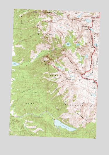
Saint Marys Lake, MT USGS Topographic Map
Click on map above to begin viewing in our Map Viewer.

This topographic map contains these locations and features:
Feature Name Type Latitude Longitude GNIS ID View Map
Dry Creek CanalCanalN47.2694°W113.9604°782591View Map
Dry LakeLakeN47.2993°W113.8794°782653View Map
Dry Lake CreekStreamN47.2594°W113.9043°798978View Map
East Saint Marys PeakSummitN47.3024°W113.9118°782952View Map
Elizabeth FallsFallsN47.3391°W113.9287°783047View Map
Fissure GlacierGlacierN47.3124°W113.8865°783473View Map
Freeman PassGapN47.3066°W113.8818°783716View Map
Glacier PeaksSummitN47.3599°W113.8979°783974View Map
Grizzly LakeLakeN47.3110°W113.8915°784357View Map
High Park PeakSummitN47.3044°W113.8829°784860View Map
Icefloe LakeLakeN47.3697°W113.9070°785213View Map
Kakashe MountainSummitN47.3510°W113.9490°785621View Map
Lake of the CloudsLakeN47.3659°W113.8930°785924View Map
Lake of the StarsLakeN47.3305°W113.8935°791454View Map
Lone Tree PassGapN47.3655°W113.8873°786499View Map
Lowary PeakSummitN47.3130°W113.9009°767977View Map
Lucifer LakeLakeN47.3419°W113.9207°786700View Map
Middle Fork Mission CreekStreamN47.3408°W113.9232°787290View Map
Mission FallsFallsN47.3366°W113.9393°787498View Map
Mission Falls CampgroundLocaleN47.3241°W113.9757°793951View Map
Mission Reservoir Campground 2LocaleN47.3197°W113.9895°793952View Map
Mount ShoemakerSummitN47.3505°W113.8795°790427View Map
Mountaineer GlacierGlacierN47.3424°W113.8798°787772View Map
Mountaineer PeakSummitN47.3394°W113.8826°787774View Map
No Fish LakeLakeN47.2930°W113.8807°788030View Map
North Fork Mission CreekStreamN47.3405°W113.9232°788212View Map
Panoramic PeakSummitN47.3691°W113.8859°788610View Map
Peak XSummitN47.3130°W113.9007°788725View Map
Peak YSummitN47.3149°W113.9057°788726View Map
Picture LakeLakeN47.3420°W113.9068°775205View Map
Power CreekStreamN47.2719°W113.9426°789164View Map
Saint Marys LakeReservoirN47.2614°W113.9228°795643View Map
Saint Marys LakeReservoirN47.2597°W113.9301°789946View Map
Saint Marys Lake CampgroundLocaleN47.2674°W113.9362°793953View Map
Sonielem LakeLakeN47.3187°W113.9308°806312View Map
Sonielem RidgeRidgeN47.3202°W113.9109°806313View Map
South Fork Mission CreekStreamN47.3341°W113.9465°791018View Map
Sunrise GlacierGlacierN47.3572°W113.8879°791703View Map
Tabor DamDamN47.2649°W113.9309°795642View Map
The Garden WallRidgeN47.3494°W113.8870°777508View Map
Vacation PassGapN47.3069°W113.9037°792667View Map
West Saint Marys PeakSummitN47.3077°W113.9215°793125View Map

Note: Coordinates in the location and feature list above are referenced to NAD83 datum.


Copyright (C) 2008-2025 Ryan Niemi / Sunset Dynamics ... All Rights Reserved