TopoQuest Logo
Do you find TopoQuest useful?
Help keep TopoQuest running and adding new maps/features by donating!
Bitcoin:  19c7KJd3qBynnjoSw5npx9KScwjBe4ifkT
Litecoin:  LXs6TkuXGGXo1vDsWCkWVdjQX94eUKd6ui
Home View Maps Find Maps Find Places Resources & Links


Saint Paul, Nebraska Topographic Map

USGS Map Title: Saint Paul, NE
USGS Map MRC: 41098B4
DRG (GeoTIFF) Download: o41098b4.tif


Neighboring USGS Topographic Map Quads:


  Elba, NE  
41098C5
 

  Wolbach SW, NE  
41098C4
 

  Cushing, NE  
41098C3
 

  Nysted, NE  
41098B5
 

  Saint Paul, NE  
41098B4
 

  Palmer, NE  
41098B3
 

  Dannebrog, NE  
41098A5
 

  Saint Paul SW, NE  
41098A4
 

  Saint Libory, NE  
41098A3


Map MRC Location:

N42°
W99°
N42°
W98°
H8 H7 H6 H5 H4 H3 H2 H1
G8 G7 G6 G5 G4 G3 G2 G1
F8 F7 F6 F5 F4 F3 F2 F1
E8 E7 E6 E5 E4 E3 E2 E1
D8 D7 D6 D5 D4 D3 D2 D1
C8 C7 C6 C5 C4 C3 C2 C1
B8 B7 B6 B5 B4 B3 B2 B1
A8 A7 A6 A5 A4 A3 A2 A1
N41°
W99°
N41°
W98°

Saint Paul, NE USGS 1:24K Topographic Map Preview:
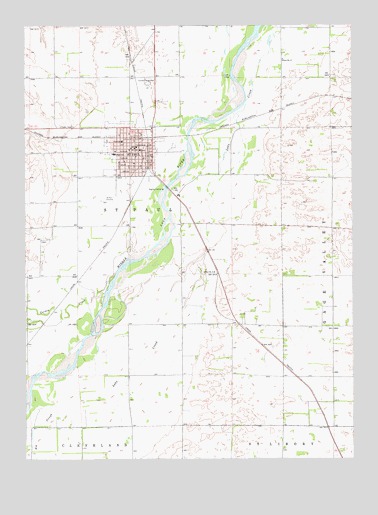
Saint Paul, NE USGS Topographic Map
Click on map above to begin viewing in our Map Viewer.

This topographic map contains these locations and features:
Feature Name Type Latitude Longitude GNIS ID View Map
Bel-Air RV ParkLocaleN41.2000°W98.4406°1874791View Map
Big SloughStreamN41.1606°W98.4728°827428View Map
Christ Lutheran ChurchChurchN41.2106°W98.4623°1874803View Map
City of Saint PaulCivilN41.2139°W98.4600°2396515View Map
Cotesfield Village Police DepartmentBuildingN41.2134°W98.4562°2739893View Map
Family Eyecare CenterHospitalN41.2131°W98.4584°1874802View Map
First Presbyterian ChurchChurchN41.2145°W98.4598°1874809View Map
Grace Baptist ChurchChurchN41.2070°W98.4606°1874807View Map
Grover Cleveland Alexander Ball FieldParkN41.2117°W98.4687°1874784View Map
Grover Cleveland Alexander Historical MarkerParkN41.1833°W98.4295°1874846View Map
Gruber HouseBuildingN41.2147°W98.4570°1874786View Map
Happy ChurchChurchN41.2136°W98.4573°1874808View Map
Heritage Living CenterHospitalN41.2150°W98.4648°1874801View Map
Howard County Community HospitalHospitalN41.2166°W98.4631°1874799View Map
Howard County CourthouseBuildingN41.2150°W98.4578°1874794View Map
Howard County FairgroundsLocaleN41.2333°W98.4531°1874777View Map
Howard County Historical VillageLocaleN41.2147°W98.4556°1874787View Map
Howard County Medical ClinicHospitalN41.2147°W98.4617°1874796View Map
Howard County Sheriff's OfficeBuildingN41.2150°W98.4574°1874795View Map
Museum of Nebraska Baseball GreatsBuildingN41.2147°W98.4570°1874785View Map
Saint Marks Lutheran ChurchChurchN41.2136°W98.4659°1874805View Map
Saint PaulLocaleN41.2181°W98.4531°1874781View Map
Saint PaulPopulated PlaceN41.2147°W98.4581°833046View Map
Saint Paul CemeteryCemeteryN41.2003°W98.4681°833049View Map
Saint Paul Chiropractic CenterHospitalN41.2156°W98.4578°1874798View Map
Saint Paul City ParkParkN41.2147°W98.4556°1874788View Map
Saint Paul Cooperative Grain Association ElevatorLocaleN41.2175°W98.4573°1874790View Map
Saint Paul Country ClubLocaleN41.1972°W98.4559°1874793View Map
Saint Paul Dental OfficeHospitalN41.2128°W98.4565°1874797View Map
Saint Paul Election PrecinctCivilN41.1997°W98.4414°1929311View Map
Saint Paul Family MedicineHospitalN41.2167°W98.4634°1874800View Map
Saint Paul Police DepartmentBuildingN41.2126°W98.4564°1874779View Map
Saint Paul Post OfficePost OfficeN41.2145°W98.4583°1874782View Map
Saint Paul Public LibraryBuildingN41.2136°W98.4565°1874780View Map
Saint Paul Public SchoolSchoolN41.2131°W98.4665°1874783View Map
Saint Paul Volunteer Fire and RescueBuildingN41.2142°W98.4564°1874778View Map
Saints Peter and Paul Catholic ChurchChurchN41.2100°W98.4587°1874806View Map
School Number 12SchoolN41.2403°W98.4017°836192View Map
School Number 15SchoolN41.1789°W98.4281°836259View Map
Scoular Company ElevatorLocaleN41.2111°W98.4537°1874789View Map
Township of Saint PaulCivilN41.2083°W98.4170°1874741View Map
Turkey CreekStreamN41.1725°W98.4540°834213View Map
United Methodist ChurchChurchN41.2083°W98.4678°1874804View Map
Walts Aerial Service Airport (historical)AirportN41.2486°W98.4562°837700View Map

Note: Coordinates in the location and feature list above are referenced to NAD83 datum.


Copyright (C) 2008-2025 Ryan Niemi / Sunset Dynamics ... All Rights Reserved