TopoQuest Logo
Do you find TopoQuest useful?
Help keep TopoQuest running and adding new maps/features by donating!
Bitcoin:  19c7KJd3qBynnjoSw5npx9KScwjBe4ifkT
Litecoin:  LXs6TkuXGGXo1vDsWCkWVdjQX94eUKd6ui
Home View Maps Find Maps Find Places Resources & Links


Saint Phillips Island, South Carolina Topographic Map

USGS Map Title: Saint Phillips Island, SC
USGS Map MRC: 32080C5
DRG (GeoTIFF) Download: o32080c5.tif


Neighboring USGS Topographic Map Quads:


  Beaufort, SC  
32080D6
 

  Frogmore, SC  
32080D5
 

  Saint Helena Sound, SC  
32080D4
 

  Parris Island, SC  
32080C6
 

  Saint Phillips Island, SC  
32080C5
 

  Fripp Inlet, SC  
32080C4
 

  Hilton Head, SC  
32080B6


Map MRC Location:

N33°
W81°
N33°
W80°
H8 H7 H6 H5 H4 H3 H2 H1
G8 G7 G6 G5 G4 G3 G2 G1
F8 F7 F6 F5 F4 F3 F2 F1
E8 E7 E6 E5 E4 E3 E2 E1
D8 D7 D6 D5 D4 D3 D2 D1
C8 C7 C6 C5 C4 C3 C2 C1
B8 B7 B6 B5 B4 B3 B2 B1
A8 A7 A6 A5 A4 A3 A2 A1
N32°
W81°
N32°
W80°

Saint Phillips Island, SC USGS 1:24K Topographic Map Preview:
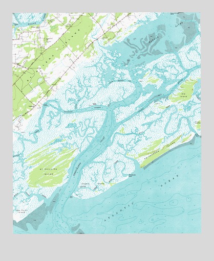
Saint Phillips Island, SC USGS Topographic Map
Click on map above to begin viewing in our Map Viewer.

This topographic map contains these locations and features:
Feature Name Type Latitude Longitude GNIS ID View Map
Beaufort County LandingLocaleN32.3235°W80.6054°1231039View Map
Bull PointCapeN32.2721°W80.5848°1247055View Map
Capers IslandIslandN32.2827°W80.5671°1221343View Map
Club Bridge CreekStreamN32.3358°W80.5451°1221648View Map
County LandingLocaleN32.3230°W80.6054°1227815View Map
Frogmore CemeteryCemeteryN32.3607°W80.5659°1222596View Map
Harbor RiverStreamN32.3199°W80.5598°1223030View Map
Lady's - Saint Helena Island Fire Department Station 23BuildingN32.3404°W80.6188°2368132View Map
Lands End School (historical)SchoolN32.3246°W80.6082°1237263View Map
LongwoodPopulated PlaceN32.3227°W80.6098°1224191View Map
Moon CreekChannelN32.2788°W80.5621°1224633View Map
Morse Island CreekChannelN32.2733°W80.6204°1249529View Map
Old IslandIslandN32.3324°W80.5084°1249961View Map
Orange Grove CemeteryCemeteryN32.3599°W80.6029°1225240View Map
Orange Grove ChurchChurchN32.3669°W80.6073°1225241View Map
Orange Grove PlantationLocaleN32.3655°W80.6068°1237301View Map
Perry CemeteryCemeteryN32.3705°W80.6001°1225372View Map
Pritchard CemeteryCemeteryN32.3591°W80.6023°1225677View Map
Pritchards InletGutN32.2844°W80.5457°1225678View Map
Pritchards IslandIslandN32.2988°W80.5262°1250251View Map
Saint Helena Island DivisionCivilN32.3612°W80.5305°1938406View Map
Saint Phillips IslandIslandN32.2844°W80.6132°1250702View Map
ScottPopulated PlaceN32.3466°W80.6232°1231783View Map
Scott CreekChannelN32.3333°W80.5765°1226456View Map
Sheep IslandIslandN32.3230°W80.5726°1226548View Map
Skull CreekGutN32.3094°W80.5354°1250922View Map
Skull InletGutN32.3069°W80.5032°1250924View Map
Station CreekChannelN32.3102°W80.6068°1251032View Map
Story RiverGutN32.3330°W80.5171°1226921View Map
Tombee CemeteryCemeteryN32.3116°W80.6207°1227170View Map
Towne-McDonald School (historical)SchoolN32.3627°W80.5662°1237407View Map
Trenchards InletGutN32.2955°W80.5740°1251200View Map
Turtle CreekStreamN32.2755°W80.5815°1227258View Map
WOCW-FM (Parris Island)TowerN32.3605°W80.5934°1252537View Map

Note: Coordinates in the location and feature list above are referenced to NAD83 datum.


Copyright (C) 2008-2024 Ryan Niemi / Sunset Dynamics ... All Rights Reserved