TopoQuest Logo
Do you find TopoQuest useful?
Help keep TopoQuest running and adding new maps/features by donating!
Bitcoin:  19c7KJd3qBynnjoSw5npx9KScwjBe4ifkT
Litecoin:  LXs6TkuXGGXo1vDsWCkWVdjQX94eUKd6ui
Home View Maps Find Maps Find Places Resources & Links


Saint Helena Sound, South Carolina Topographic Map

USGS Map Title: Saint Helena Sound, SC
USGS Map MRC: 32080D4
DRG (GeoTIFF) Download: o32080d4.tif


Neighboring USGS Topographic Map Quads:


  Wiggins, SC  
32080E5
 

  Bennetts Point, SC  
32080E4
 

  Edisto Island, SC  
32080E3
 

  Frogmore, SC  
32080D5
 

  Saint Helena Sound, SC  
32080D4
 

  Edisto Beach, SC  
32080D3
 

  Saint Phillips Island, SC  
32080C5
 

  Fripp Inlet, SC  
32080C4


Map MRC Location:

N33°
W81°
N33°
W80°
H8 H7 H6 H5 H4 H3 H2 H1
G8 G7 G6 G5 G4 G3 G2 G1
F8 F7 F6 F5 F4 F3 F2 F1
E8 E7 E6 E5 E4 E3 E2 E1
D8 D7 D6 D5 D4 D3 D2 D1
C8 C7 C6 C5 C4 C3 C2 C1
B8 B7 B6 B5 B4 B3 B2 B1
A8 A7 A6 A5 A4 A3 A2 A1
N32°
W81°
N32°
W80°

Saint Helena Sound, SC USGS 1:24K Topographic Map Preview:
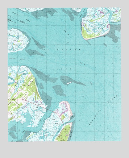
Saint Helena Sound, SC USGS Topographic Map
Click on map above to begin viewing in our Map Viewer.

This topographic map contains these locations and features:
Feature Name Type Latitude Longitude GNIS ID View Map
Ashepoo RiverStreamN32.4902°W80.4237°1244932View Map
Big House CemeteryCemeteryN32.4010°W80.4965°1220704View Map
Butchers IslandIslandN32.4088°W80.4626°1221159View Map
Cedar Reef VillasPopulated PlaceN32.4052°W80.4326°1237159View Map
Coffin CreekStreamN32.4463°W80.4862°1221660View Map
Coffin PointCapeN32.4338°W80.4734°1247331View Map
Coffin Point CemeteryCemeteryN32.4313°W80.4762°1221661View Map
Coffin Point PlantationLocaleN32.4335°W80.4765°1237172View Map
Combahee BankBarN32.4763°W80.4343°1221229View Map
Coosaw RiverStreamN32.4835°W80.4748°1221748View Map
Egg BankBarN32.4299°W80.4320°1222247View Map
Fish CreekStreamN32.4860°W80.3862°1222402View Map
Fripps PointCapeN32.4349°W80.4879°1222594View Map
Harbor IslandIslandN32.3880°W80.4529°1245902View Map
Horse IslandIslandN32.3960°W80.4968°1223320View Map
Hunting Island LighthouseLocaleN32.3755°W80.4376°1223401View Map
Jefford CreekStreamN32.4960°W80.3882°1223526View Map
Johnson CreekGutN32.3769°W80.4498°1246183View Map
Lee Rosenwald School (historical)SchoolN32.4102°W80.4993°1237267View Map
Marsh Island SpitBarN32.4880°W80.4970°1220107View Map
Morgan RiverStreamN32.4527°W80.4729°1246723View Map
Nautical Watch VillasPopulated PlaceN32.4021°W80.4345°1237287View Map
Oceanmarsh SubdivisionPopulated PlaceN32.3982°W80.4393°1237296View Map
Otter CreekChannelN32.4813°W80.4012°1225255View Map
Otter IslandsIslandN32.4838°W80.4029°1225257View Map
Oyster BankBarN32.4355°W80.4609°1241277View Map
Pelican BankBarN32.4461°W80.4222°1250053View Map
Pelican PointCapeN32.4007°W80.4282°1237314View Map
Pine IslandIslandN32.4924°W80.3801°1250117View Map
Pine Island CreekStreamN32.4963°W80.3843°1225462View Map
Saint Helena SoundBayN32.4546°W80.4404°1226101View Map
Ward CreekStreamN32.4019°W80.4587°1227395View Map
WHTK-FM (Port Royal)TowerN32.4196°W80.4748°1252538View Map

Note: Coordinates in the location and feature list above are referenced to NAD83 datum.


Copyright (C) 2008-2025 Ryan Niemi / Sunset Dynamics ... All Rights Reserved