TopoQuest Logo
Do you find TopoQuest useful?
Help keep TopoQuest running and adding new maps/features by donating!
Bitcoin:  19c7KJd3qBynnjoSw5npx9KScwjBe4ifkT
Litecoin:  LXs6TkuXGGXo1vDsWCkWVdjQX94eUKd6ui
Home View Maps Find Maps Find Places Resources & Links


Albany, Minnesota Topographic Map

USGS Map Title: Albany, MN
USGS Map MRC: 45094F5
DRG (GeoTIFF) Download: o45094f5.tif


Neighboring USGS Topographic Map Quads:


  Burtrum, MN  
45094G6
 

  Upsala, MN  
45094G5
 

  Bowlus, MN  
45094G4
 

  Freeport, MN  
45094F6
 

  Albany, MN  
45094F5
 

  Holdingford, MN  
45094F4
 

  Saint Martin, MN  
45094E6
 

  Farming, MN  
45094E5
 

  Avon, MN  
45094E4


Map MRC Location:

N46°
W95°
N46°
W94°
H8 H7 H6 H5 H4 H3 H2 H1
G8 G7 G6 G5 G4 G3 G2 G1
F8 F7 F6 F5 F4 F3 F2 F1
E8 E7 E6 E5 E4 E3 E2 E1
D8 D7 D6 D5 D4 D3 D2 D1
C8 C7 C6 C5 C4 C3 C2 C1
B8 B7 B6 B5 B4 B3 B2 B1
A8 A7 A6 A5 A4 A3 A2 A1
N45°
W95°
N45°
W94°

Albany, MN USGS 1:24K Topographic Map Preview:
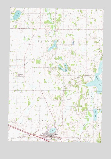
Albany, MN USGS Topographic Map
Click on map above to begin viewing in our Map Viewer.

This topographic map contains these locations and features:
Feature Name Type Latitude Longitude GNIS ID View Map
AlbanyPopulated PlaceN45.6300°W94.5700°639241View Map
Albany (historical)LocaleN45.6300°W94.5717°2068317View Map
Albany Area Hospital and Medical CenterHospitalN45.6387°W94.5668°2068319View Map
Albany Fire DepartmentBuildingN45.6315°W94.5685°2068311View Map
Albany Golf ClubLocaleN45.6272°W94.5667°2068326View Map
Albany Medical CenterHospitalN45.6389°W94.5667°2068318View Map
Albany Police DeptBuildingN45.6300°W94.5684°2068314View Map
Albany Post OfficePost OfficeN45.6303°W94.5692°2068313View Map
Albany Public LibraryBuildingN45.6303°W94.5689°2068315View Map
Albany Senior High SchoolSchoolN45.6319°W94.5611°2068323View Map
Albany Softball ParkParkN45.6347°W94.5606°2068312View Map
Bear LakeLakeN45.6962°W94.5492°639769View Map
City of AlbanyCivilN45.6283°W94.5675°2393898View Map
City of Saint AnthonyCivilN45.6890°W94.6115°2396472View Map
County Ditch Number FifteenCanalN45.6377°W94.6111°641704View Map
County Ditch Number TwentytwoCanalN45.6772°W94.5961°641828View Map
Ebenezer CemeteryCemeteryN45.6297°W94.5586°643137View Map
Fish LakeLakeN45.6938°W94.5552°643684View Map
Holy Family SchoolSchoolN45.6278°W94.5653°2068322View Map
Interchange 147CrossingN45.6267°W94.5750°2068398View Map
KASM-AM (Albany)TowerN45.6330°W94.6003°662887View Map
Little Mud LakeLakeN45.6552°W94.5012°646866View Map
Littner LakeLakeN45.6922°W94.5492°646971View Map
Mother of Mercy Nursing HomeHospitalN45.6297°W94.5667°2068320View Map
North LakeLakeN45.6356°W94.5652°639242View Map
Our Saviour's Lutheran ChurchChurchN45.6336°W94.5744°2068324View Map
Pine LakeLakeN45.6514°W94.5086°649473View Map
Saint Anna LakeLakeN45.7430°W94.6159°650501View Map
Saint AnthonyPopulated PlaceN45.6866°W94.6122°650514View Map
Saint Anthony ChurchChurchN45.6864°W94.6106°2068325View Map
Saint Anthony Post Office (historical)Post OfficeN45.6867°W94.6119°2068288View Map
Saint Johns CemeteryCemeteryN45.7208°W94.5591°650687View Map
School Number 2031SchoolN45.6430°W94.6150°651480View Map
School Number 2043SchoolN45.7308°W94.6053°651484View Map
School Number 2077SchoolN45.7019°W94.5219°651496View Map
School Number 2081SchoolN45.7047°W94.5797°651498View Map
Seven Dolors CemeteryCemeteryN45.6281°W94.5633°651860View Map
Seven Dolors SchoolSchoolN45.6278°W94.5653°2068321View Map
Shamrock Mobile Home ParkPopulated PlaceN45.6283°W94.5769°2068316View Map
Skalicky Airstrip (historical)AirportN45.6619°W94.5756°660029View Map
Township of KrainCivilN45.7237°W94.5779°664645View Map
Two River LakeLakeN45.6846°W94.5057°653473View Map
Vos LakeLakeN45.7144°W94.5671°653687View Map
Warga Dairy FarmLocaleN45.7394°W94.5036°2635898View Map

Note: Coordinates in the location and feature list above are referenced to NAD83 datum.


Copyright (C) 2008-2024 Ryan Niemi / Sunset Dynamics ... All Rights Reserved