TopoQuest Logo
Do you find TopoQuest useful?
Help keep TopoQuest running and adding new maps/features by donating!
Bitcoin:  19c7KJd3qBynnjoSw5npx9KScwjBe4ifkT
Litecoin:  LXs6TkuXGGXo1vDsWCkWVdjQX94eUKd6ui
Home View Maps Find Maps Find Places Resources & Links


Salem, South Carolina Topographic Map

USGS Map Title: Salem, SC
USGS Map MRC: 34082H8
DRG (GeoTIFF) Download: o34082h8.tif


Neighboring USGS Topographic Map Quads:


  Cashiers, NC  
35083A1
 

  Reid, NC  
35082A8
 

  Eastatoe Gap, NC  
35082A7
 

  Tamassee, SC  
34083H1
 

  Salem, SC  
34082H8
 

  Sunset, SC  
34082H7
 

  Walhalla, SC  
34083G1
 

  Old Pickens, SC  
34082G8
 

  Six Mile, SC  
34082G7


Map MRC Location:

N35°
W83°
N35°
W82°
H8 H7 H6 H5 H4 H3 H2 H1
G8 G7 G6 G5 G4 G3 G2 G1
F8 F7 F6 F5 F4 F3 F2 F1
E8 E7 E6 E5 E4 E3 E2 E1
D8 D7 D6 D5 D4 D3 D2 D1
C8 C7 C6 C5 C4 C3 C2 C1
B8 B7 B6 B5 B4 B3 B2 B1
A8 A7 A6 A5 A4 A3 A2 A1
N34°
W83°
N34°
W82°

Salem, SC USGS 1:24K Topographic Map Preview:
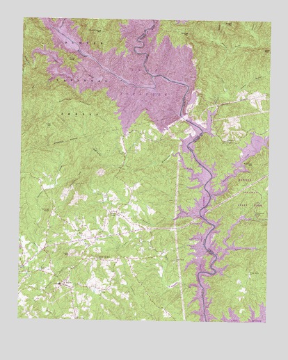
Salem, SC USGS Topographic Map
Click on map above to begin viewing in our Map Viewer.

This topographic map contains these locations and features:
Feature Name Type Latitude Longitude GNIS ID View Map
Bad CreekStreamN34.9768°W82.9826°1229371View Map
Barbecue BranchStreamN34.8868°W82.9888°1229375View Map
Bethel Baptist Church (historical)ChurchN34.9140°W82.8957°1243254View Map
Bethel CemeteryCemeteryN34.9140°W82.8965°1243255View Map
Betsy Akin BranchStreamN34.9493°W82.8771°1229406View Map
Boone Creek School Number 1 (historical)SchoolN34.9337°W82.9168°1242924View Map
Boone Creek School Number 2 (historical)SchoolN34.9201°W82.9504°1242925View Map
Boones CreekPopulated PlaceN34.9201°W82.9510°1229447View Map
Boones CreekStreamN34.9190°W82.9088°1246943View Map
Boones Creek ChurchChurchN34.9198°W82.9499°1242926View Map
Bootleg MountainSummitN34.9945°W82.9165°1246945View Map
Browns LakeReservoirN34.8961°W82.9891°1229465View Map
Bryant MountainSummitN34.9987°W82.8943°1229472View Map
Bully BranchStreamN34.9870°W82.8968°1229485View Map
Camp JocasseeLocaleN34.9726°W82.9407°1229506View Map
Camp Jocassee (historical)LocaleN34.9725°W82.9417°1242934View Map
Cane CreekStreamN34.9543°W82.9085°1229518View Map
Cane Creek School (historical)SchoolN34.9493°W82.8965°1243278View Map
Cedar CreekStreamN34.9015°W82.8996°1229532View Map
Chapman BridgeBridgeN34.9554°W82.9099°1247252View Map
Chapman Bridge (historical)BridgeN34.9543°W82.9088°1243291View Map
Church of GodChurchN34.9109°W82.9693°1242940View Map
Clearwater FallsFallsN34.9204°W82.8810°1229565View Map
Corbin CreekStreamN34.9809°W82.9968°1229591View Map
Dammo BranchStreamN34.9707°W82.8963°1229618View Map
Devils ForkStreamN34.9787°W82.9582°1247525View Map
Double Spring MountainSummitN34.9951°W82.9604°1229649View Map
EastatoePopulated PlaceN34.9520°W82.9004°1243332View Map
Eastatoe CreekStreamN34.9270°W82.9038°1011006View Map
Fall CreekPopulated PlaceN34.9015°W82.9204°1242988View Map
Fall CreekStreamN34.8895°W82.9076°1247725View Map
Fall Creek Baptist ChurchChurchN34.9001°W82.9207°1247727View Map
Fall Creek CemeteryCemeteryN34.9003°W82.9208°1244799View Map
Fiddlers CreekStreamN34.8959°W82.9965°1229697View Map
Fisher KnobSummitN34.9831°W82.9765°1231284View Map
Hemlock Club (historical)LocaleN34.9856°W82.9682°1243013View Map
Howard CreekStreamN34.9851°W82.9882°1229828View Map
JocasseePopulated PlaceN34.9709°W82.9374°1229860View Map
Jocassee (historical)Populated PlaceN34.9709°W82.9354°1243025View Map
Jocassee DamDamN34.9601°W82.9193°1238307View Map
Jocassee Post Office (historical)Post OfficeN34.9620°W82.9229°1252279View Map
Jocassee School (historical)SchoolN34.9684°W82.9379°1243026View Map
Keowee School (historical)SchoolN34.8834°W82.8774°1243404View Map
Keowee Toxaway State ParkParkN34.9298°W82.8840°1243405View Map
Lake JocasseReservoirN34.9601°W82.9149°1238308View Map
Lake JocasseeReservoirN34.9926°W82.9398°1230532View Map
Little Cedar CreekStreamN34.9057°W82.8938°1229914View Map
Lydia MountainSummitN34.9023°W82.9743°1229961View Map
McKenneys Ford (historical)CrossingN34.9598°W82.9188°1243433View Map
McKinney ChapelChurchN34.9498°W82.8965°1246599View Map
McKinney Chapel CemeteryCemeteryN34.9498°W82.8965°1243434View Map
McKinney MountainSummitN34.9407°W82.8826°1229992View Map
McKinneys CreekStreamN34.9318°W82.9068°1246601View Map
McKinneys MountainSummitN34.9651°W82.9796°1231533View Map
Mina-Tonka Lodge (historical)LocaleN34.9773°W82.9571°1243057View Map
Mount Carmel Cemetery (historical)CemeteryN34.9682°W82.9374°1243059View Map
Mount Carmel ChurchChurchN34.9665°W82.9418°1230051View Map
Mount Carmel Church (historical)ChurchN34.9684°W82.9374°1243060View Map
Oconee County Rural Fire Department SalemBuildingN34.8898°W82.9762°2578389View Map
Piney Grove ChurchChurchN34.8954°W82.8838°1230175View Map
Piney MountainSummitN34.9876°W82.8782°1230176View Map
Poe CreekStreamN34.9382°W82.8865°1250199View Map
River View Lodge (historical)LocaleN34.9962°W82.9832°1243128View Map
Rochester Little Lake Dam D-1523DamN34.9051°W82.9999°1239768View Map
SalemPopulated PlaceN34.8898°W82.9765°1230283View Map
Salem Davidian ChurchChurchN34.9001°W82.9599°1250731View Map
Salem DivisionCivilN34.9304°W82.9658°1938409View Map
Shallow Ford Bridge (historical)BridgeN34.9062°W82.9060°1230320View Map
Smeltzer CreekStreamN34.9051°W82.9915°1230335View Map
Smeltzer MountainSummitN34.9373°W82.9685°1230336View Map
Smeltzer School (historical)SchoolN34.9343°W82.9943°1243159View Map
South Carolina Noname 39018 DamDamN34.9584°W82.9132°1238599View Map
Tamassee/Salem Middle-High SchoolSchoolN34.8898°W82.9790°1243179View Map
Tater HillSummitN34.9559°W82.9846°1231853View Map
Thompson RiverStreamN34.9943°W82.9818°1016125View Map
Tommys KnobSummitN34.9206°W82.9849°1231866View Map
Town of SalemCivilN34.8879°W82.9752°2407275View Map
Toxaway LakeReservoirN34.9584°W82.9132°1238600View Map
Toxaway RiverStreamN34.9768°W82.9346°1016210View Map
Whitewater RiverStreamN34.9765°W82.9340°1016637View Map

Note: Coordinates in the location and feature list above are referenced to NAD83 datum.


Copyright (C) 2008-2025 Ryan Niemi / Sunset Dynamics ... All Rights Reserved