TopoQuest Logo
Do you find TopoQuest useful?
Help keep TopoQuest running and adding new maps/features by donating!
Bitcoin:  19c7KJd3qBynnjoSw5npx9KScwjBe4ifkT
Litecoin:  LXs6TkuXGGXo1vDsWCkWVdjQX94eUKd6ui
Home View Maps Find Maps Find Places Resources & Links


Salem South, Illinois Topographic Map

USGS Map Title: Salem South, IL
USGS Map MRC: 38088E8
DRG (GeoTIFF) Download: o38088e8.tif


Neighboring USGS Topographic Map Quads:


  Fairman, IL  
38089F1
 

  Salem North, IL  
38088F8
 

  Omega, IL  
38088F7
 

  Centralia East, IL  
38089E1
 

  Salem South, IL  
38088E8
 

  Iuka, IL  
38088E7
 

  Walnut Hill, IL  
38089D1
 

  Kell, IL  
38088D8
 

  Harmony, IL  
38088D7


Map MRC Location:

N39°
W89°
N39°
W88°
H8 H7 H6 H5 H4 H3 H2 H1
G8 G7 G6 G5 G4 G3 G2 G1
F8 F7 F6 F5 F4 F3 F2 F1
E8 E7 E6 E5 E4 E3 E2 E1
D8 D7 D6 D5 D4 D3 D2 D1
C8 C7 C6 C5 C4 C3 C2 C1
B8 B7 B6 B5 B4 B3 B2 B1
A8 A7 A6 A5 A4 A3 A2 A1
N38°
W89°
N38°
W88°

Salem South, IL USGS 1:24K Topographic Map Preview:
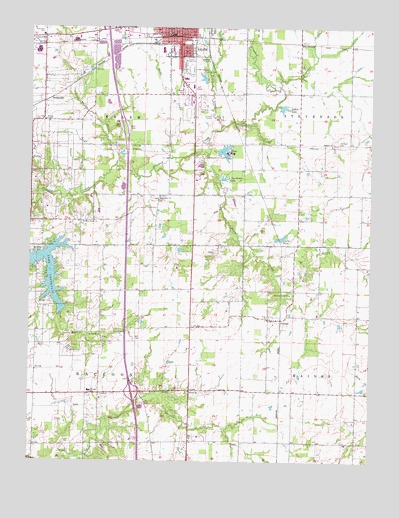
Salem South, IL USGS Topographic Map
Click on map above to begin viewing in our Map Viewer.

This topographic map contains these locations and features:
Feature Name Type Latitude Longitude GNIS ID View Map
Air and Medical Emergency ServicesBuildingN38.5964°W88.9991°2673823View Map
Antioch CemeteryCemeteryN38.5462°W88.9970°403543View Map
Bethlehem CemeteryCemeteryN38.5764°W88.9520°1821373View Map
Bethlehem Missionary Baptist ChurchChurchN38.5764°W88.9526°404340View Map
Branch CemeteryCemeteryN38.5609°W88.9945°404794View Map
Broadway Christian ChurchChurchN38.6248°W88.9453°1821377View Map
Brubaker CreekStreamN38.6084°W88.9087°404993View Map
CartterPopulated PlaceN38.5412°W88.9123°405661View Map
Cartter PondReservoirN38.5639°W88.9101°405662View Map
Cartter Pond DamDamN38.5639°W88.9101°1692292View Map
Cartter Post Office (historical)Post OfficeN38.5412°W88.9095°1821379View Map
Central SchoolSchoolN38.6248°W88.9481°405878View Map
Dunkard CemeteryCemeteryN38.5917°W88.8873°407498View Map
East Nation School (historical)SchoolN38.5773°W88.9398°1737041View Map
Excelsior School (historical)SchoolN38.6067°W88.9012°1737045View Map
First General Baptist ChurchChurchN38.6184°W88.9437°1821400View Map
Folks CreekStreamN38.5875°W88.9495°408481View Map
FoxvillePopulated PlaceN38.5200°W88.8798°1821403View Map
Gaston Grove Church (historical)ChurchN38.5628°W88.8901°1737050View Map
Harvey CreekStreamN38.5489°W88.9064°409905View Map
Harveys Point CemeteryCemeteryN38.5478°W88.9048°1821407View Map
Harveys Point ChurchChurchN38.5484°W88.9045°409907View Map
Harveys Point School (historical)SchoolN38.5489°W88.9034°1737056View Map
Hecks LakeReservoirN38.5879°W88.9287°410021View Map
Hecks Lake DamDamN38.5889°W88.9314°1691221View Map
Huff School (historical)SchoolN38.5775°W88.9012°1737060View Map
Interchange 109CrossingN38.5200°W88.9620°1821410View Map
Lake CentraliaReservoirN38.5467°W88.9954°405913View Map
Lofton LakeReservoirN38.6020°W88.9075°412504View Map
Marion County FairgroundLocaleN38.6137°W88.9423°1737072View Map
Martin BranchStreamN38.5423°W88.9887°413062View Map
Mercer School (historical)SchoolN38.5198°W88.9784°1737074View Map
Mount Moriah CemeteryCemeteryN38.5356°W88.9739°1821426View Map
Mount Moriah ChurchChurchN38.5356°W88.9737°413997View Map
Paradise CemeteryCemeteryN38.6012°W88.9392°415370View Map
Pleasant Grove ChurchChurchN38.5689°W88.9812°415790View Map
Purdue CemeteryCemeteryN38.5117°W88.8831°417049View Map
Raccoon SchoolSchoolN38.5200°W88.9776°416338View Map
Raccoon TownhallBuildingN38.5192°W88.9737°1737085View Map
Rainey School (historical)SchoolN38.5456°W88.9412°1737086View Map
Ray School (historical)SchoolN38.5487°W88.9742°1737088View Map
Romine ChurchChurchN38.5203°W88.9412°416900View Map
Romine Church of the BrethrenChurchN38.5914°W88.8898°416901View Map
Romine Prairie CemeteryCemeteryN38.5200°W88.9459°416899View Map
Romine School (historical)SchoolN38.5200°W88.9412°1737093View Map
Salem Church of GodChurchN38.6209°W88.9506°1821446View Map
Salem Country ClubLocaleN38.6120°W88.9373°425439View Map
Salem Drive-InLocaleN38.5739°W88.9417°2634329View Map
Salem Fire Protection District Omar Squibb Training FacilityBuildingN38.5923°W88.9995°2640573View Map
Salem LandfillLocaleN38.6189°W88.9336°2680876View Map
Salem Post OfficePost OfficeN38.6237°W88.9617°1737095View Map
Salem Sewage Treatment PlantLocaleN38.6153°W88.9372°2680897View Map
SelmavillePopulated PlaceN38.6070°W88.9953°418193View Map
Shanafelt SchoolSchoolN38.6225°W88.9959°418277View Map
Southside School (historical)SchoolN38.6014°W88.9501°1737101View Map
Sportsman LakeReservoirN38.5816°W88.9289°418913View Map
Sportsman Lake DamDamN38.5814°W88.9301°1691522View Map
Synder CemeteryCemeteryN38.5314°W88.9848°419513View Map
Telford School (historical)SchoolN38.5206°W88.9034°1737105View Map
Town CreekStreamN38.5970°W88.9303°419805View Map
Township of RaccoonCivilN38.5187°W88.9774°429613View Map
Township of SalemCivilN38.6055°W88.9766°429703View Map
Vermilion CreekStreamN38.5853°W88.9692°420258View Map
WCEE-TV (Mount Vernon)TowerN38.5442°W88.9240°428346View Map
WJBD-FM (Salem)TowerN38.5625°W88.9992°428295View Map
Youngs Chapel Christian ChurchChurchN38.5984°W88.9951°421596View Map

Note: Coordinates in the location and feature list above are referenced to NAD83 datum.


Copyright (C) 2008-2024 Ryan Niemi / Sunset Dynamics ... All Rights Reserved