TopoQuest Logo
Do you find TopoQuest useful?
Help keep TopoQuest running and adding new maps/features by donating!
Bitcoin:  19c7KJd3qBynnjoSw5npx9KScwjBe4ifkT
Litecoin:  LXs6TkuXGGXo1vDsWCkWVdjQX94eUKd6ui
Home View Maps Find Maps Find Places Resources & Links


Salem North, Illinois Topographic Map

USGS Map Title: Salem North, IL
USGS Map MRC: 38088F8
DRG (GeoTIFF) Download: o38088f8.tif


Neighboring USGS Topographic Map Quads:


  Patoka, IL  
38089G1
 

  Saint Paul, IL  
38088G8
 

  Kinmundy, IL  
38088G7
 

  Fairman, IL  
38089F1
 

  Salem North, IL  
38088F8
 

  Omega, IL  
38088F7
 

  Centralia East, IL  
38089E1
 

  Salem South, IL  
38088E8
 

  Iuka, IL  
38088E7


Map MRC Location:

N39°
W89°
N39°
W88°
H8 H7 H6 H5 H4 H3 H2 H1
G8 G7 G6 G5 G4 G3 G2 G1
F8 F7 F6 F5 F4 F3 F2 F1
E8 E7 E6 E5 E4 E3 E2 E1
D8 D7 D6 D5 D4 D3 D2 D1
C8 C7 C6 C5 C4 C3 C2 C1
B8 B7 B6 B5 B4 B3 B2 B1
A8 A7 A6 A5 A4 A3 A2 A1
N38°
W89°
N38°
W88°

Salem North, IL USGS 1:24K Topographic Map Preview:
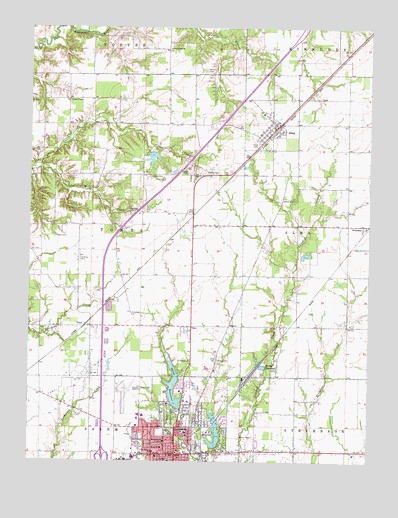
Salem North, IL USGS Topographic Map
Click on map above to begin viewing in our Map Viewer.

This topographic map contains these locations and features:
Feature Name Type Latitude Longitude GNIS ID View Map
Allman CemeteryCemeteryN38.7070°W88.9559°403448View Map
Allmon School (historical)SchoolN38.6970°W88.9495°1737020View Map
AlmaPopulated PlaceN38.7217°W88.9092°403451View Map
Alma CemeteryCemeteryN38.7164°W88.9162°403452View Map
Alma Post OfficePost OfficeN38.7216°W88.9107°2788207View Map
Bible Baptist ChurchChurchN38.6267°W88.9481°1821374View Map
Bible Fellowship ChurchChurchN38.6298°W88.9545°1821375View Map
Black CemeteryCemeteryN38.6895°W88.9901°404485View Map
BrubakerPopulated PlaceN38.6931°W88.8764°404992View Map
Bryan Memorial ParkCemeteryN38.6384°W88.9473°405071View Map
C and E I Reservoir DamDamN38.6289°W88.9317°1691223View Map
C and EI ReservoirReservoirN38.6335°W88.9312°405323View Map
Calvary ChurchChurchN38.7078°W88.9423°405407View Map
Central Christian ChurchChurchN38.6312°W88.9539°1821380View Map
City of SalemCivilN38.6278°W88.9580°2396526View Map
Clapp CemeteryCemeteryN38.6495°W88.9467°406140View Map
Eagan CemeteryCemeteryN38.6542°W88.9303°407558View Map
East Lawn CemeteryCemeteryN38.6295°W88.9376°407716View Map
East Union School (historical)SchoolN38.6492°W88.8987°1737042View Map
Fabick Three HeliportAirportN38.6262°W88.9631°427784View Map
Fairview School (historical)SchoolN38.6678°W88.9617°1737047View Map
First Baptist ChurchChurchN38.6264°W88.9526°1821394View Map
First Church of GodChurchN38.6325°W88.9417°1821398View Map
Free Methodist ChurchChurchN38.6259°W88.9406°1821405View Map
Friendship Church (historical)ChurchN38.6934°W88.9709°1737049View Map
Frosty Acres LakeReservoirN38.6846°W88.8985°1691545View Map
Frosty Acres Lake DamDamN38.6834°W88.9001°1691544View Map
Givens ChapelChurchN38.7292°W88.9859°409044View Map
Grace United Methodist ChurchChurchN38.6281°W88.9448°1821406View Map
Green Ridge ChurchChurchN38.7439°W88.9489°409395View Map
Green Ridge School (historical)SchoolN38.7439°W88.9492°1737053View Map
Happy Hollow School (historical)SchoolN38.6931°W88.8953°1737055View Map
Hartlin CemeteryCemeteryN38.7084°W88.9309°409886View Map
Hulls GroveWoodsN38.6381°W88.9473°1821409View Map
Interchange 116CrossingN38.6262°W88.9723°1821411View Map
Marion CountyCivilN38.6496°W88.9190°424259View Map
Marion County CourthouseBuildingN38.6275°W88.9451°1737071View Map
Marion County Emergency Medical ServicesBuildingN38.6261°W88.9434°2674063View Map
Marion County Sheriff's OfficeBuildingN38.6284°W88.9439°2758858View Map
Martin CemeteryCemeteryN38.7378°W88.9353°413065View Map
Moose ReservoirReservoirN38.6524°W88.9140°413800View Map
Oak Grove School (historical)SchoolN38.7220°W88.9495°1737078View Map
Phelps School (historical)SchoolN38.6284°W88.8923°1737081View Map
Pleasant Hill School (historical)SchoolN38.7295°W88.8828°1737082View Map
Reorganized Church of Jesus Christ of Latter Day SaintsChurchN38.6323°W88.9539°1821437View Map
Rochester-Goodell ReservoirReservoirN38.7125°W88.9551°1691230View Map
Rochester-Goodell Reservoir DamDamN38.7134°W88.9551°1691229View Map
Saint Theresa of Avila ChurchChurchN38.6273°W88.9539°1821443View Map
Saint Theresa SchoolSchoolN38.6278°W88.9537°417813View Map
Saint Thomas Episcopal ChurchChurchN38.6273°W88.9503°1821444View Map
SalemPopulated PlaceN38.6270°W88.9456°417854View Map
Salem Area AmbulanceBuildingN38.6285°W88.9614°2673829View Map
Salem Church of ChristChurchN38.6273°W88.9339°1821445View Map
Salem Community High SchoolSchoolN38.6375°W88.9428°1821447View Map
Salem Female Academy (historical)SchoolN38.6309°W88.9498°1821448View Map
Salem Fire Protection DistrictBuildingN38.6260°W88.9460°2640468View Map
Salem Police DepartmentBuildingN38.6260°W88.9433°2759081View Map
Salem Presbyterian ChurchChurchN38.6259°W88.9442°1821449View Map
Salem ReservoirReservoirN38.6463°W88.9465°417881View Map
Salem Reservoir DamDamN38.6406°W88.9456°1691231View Map
Salem Township HospitalHospitalN38.6417°W88.9487°1821433View Map
Salem-Leckrone AirportAirportN38.6429°W88.9642°427783View Map
TontiPopulated PlaceN38.6648°W88.9784°423249View Map
Tonti Oil FieldOilfieldN38.6503°W88.9795°425562View Map
Tonti TownhallBuildingN38.6678°W88.9617°1737106View Map
Township of TontiCivilN38.6927°W88.9764°429837View Map
Trinity United Methodist ChurchChurchN38.6350°W88.9553°1821464View Map
Tully ParkParkN38.6320°W88.9373°419916View Map
Union School (historical)SchoolN38.6639°W88.9128°1737109View Map
Village of AlmaCivilN38.7231°W88.9119°2397940View Map
Wills CreekStreamN38.7103°W88.9973°421273View Map
Wilson CemeteryCemeteryN38.7009°W88.9028°421286View Map
WJBD-AM (Salem)TowerN38.6323°W88.9173°428081View Map
Woodward School (historical)SchoolN38.6709°W88.9956°1737115View Map
Zion ChurchChurchN38.6645°W88.9259°421648View Map

Note: Coordinates in the location and feature list above are referenced to NAD83 datum.


Copyright (C) 2008-2024 Ryan Niemi / Sunset Dynamics ... All Rights Reserved