TopoQuest Logo
Do you find TopoQuest useful?
Help keep TopoQuest running and adding new maps/features by donating!
Bitcoin:  19c7KJd3qBynnjoSw5npx9KScwjBe4ifkT
Litecoin:  LXs6TkuXGGXo1vDsWCkWVdjQX94eUKd6ui
Home View Maps Find Maps Find Places Resources & Links


San Acacia, New Mexico Topographic Map

USGS Map Title: San Acacia, NM
USGS Map MRC: 34106C8
DRG (GeoTIFF) Download: o34106c8.tif


Neighboring USGS Topographic Map Quads:


  Ladron Peak, NM  
34107D1
 

  La Joya NW, NM  
34106D8
 

  Abeytas, NM  
34106D7
 

  Silver Creek, NM  
34107C1
 

  San Acacia, NM  
34106C8
 

  La Joya, NM  
34106C7
 

  San Lorenzo Spring, NM  
34107B1
 

  Lemitar, NM  
34106B8
 

  Mesa Del Yeso, NM  
34106B7


Map MRC Location:

N35°
W107°
N35°
W106°
H8 H7 H6 H5 H4 H3 H2 H1
G8 G7 G6 G5 G4 G3 G2 G1
F8 F7 F6 F5 F4 F3 F2 F1
E8 E7 E6 E5 E4 E3 E2 E1
D8 D7 D6 D5 D4 D3 D2 D1
C8 C7 C6 C5 C4 C3 C2 C1
B8 B7 B6 B5 B4 B3 B2 B1
A8 A7 A6 A5 A4 A3 A2 A1
N34°
W107°
N34°
W106°

San Acacia, NM USGS 1:24K Topographic Map Preview:
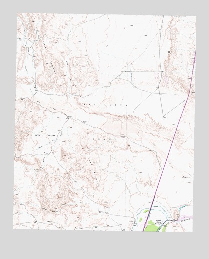
San Acacia, NM USGS Topographic Map
Click on map above to begin viewing in our Map Viewer.

This topographic map contains these locations and features:
Feature Name Type Latitude Longitude GNIS ID View Map
10021 Water WellWellN34.3398°W106.9325°926133View Map
10022 Water WellWellN34.3048°W106.9245°925852View Map
43 Water WellWellN34.2612°W106.9006°925864View Map
A1 Water WellWellN34.2612°W106.9006°925645View Map
AlamilloPopulated PlaceN34.2548°W106.9161°899495View Map
Alamillo Census Designated PlaceCensusN34.2519°W106.9158°2584045View Map
Alamillo DitchCanalN34.2628°W106.9089°885611View Map
Arroyo ChantheStreamN34.2620°W106.9142°897625View Map
Arroyo RendijaStreamN34.3034°W106.9706°897668View Map
Arroyo Tio LinoStreamN34.3198°W106.9589°897683View Map
B1 Water WellWellN34.2612°W106.9006°925865View Map
Bachelder-Everhart ProspectMineN34.2501°W106.8756°916535View Map
Caņada de la TortolaStreamN34.3156°W106.9553°897700View Map
Caņada PopotosaStreamN34.3278°W106.9886°897733View Map
Caņon de OjitoValleyN34.2667°W106.9425°897771View Map
Cerritos de las MinasRangeN34.2681°W106.9800°897531View Map
D1 Water WellWellN34.2612°W106.9006°925867View Map
F1 Water WellWellN34.2612°W106.9006°925868View Map
F2 Water WellWellN34.2612°W106.9006°925671View Map
G1 Water WellWellN34.2612°W106.9006°925647View Map
G2 Water WellWellN34.2612°W106.9006°925648View Map
H1 Water WellWellN34.2612°W106.9006°925649View Map
H2 Water WellWellN34.2612°W106.9006°925651View Map
I1 Water WellWellN34.2612°W106.9006°925650View Map
Joyita ProspectsMineN34.2501°W106.8756°916536View Map
Loma BlancaSummitN34.2951°W106.9506°899825View Map
Rest Area Water WellWellN34.3109°W106.8884°925855View Map
Rio Salado Sand Dunes Historical MarkerParkN34.2731°W106.8761°932411View Map
San AcaciaPopulated PlaceN34.2553°W106.8995°923674View Map
San Acacia Census Designated PlaceCensusN34.2549°W106.9022°2584198View Map
San Acacia Post OfficePost OfficeN34.2553°W106.8995°938094View Map
San Acacia-Polvadera InterchangeCrossingN34.2540°W106.9095°929154View Map
Sevilleta Water WellWellN34.3520°W106.8850°925662View Map
Valle FrutosaAreaN34.3045°W106.9798°896080View Map

Note: Coordinates in the location and feature list above are referenced to NAD83 datum.


Copyright (C) 2008-2024 Ryan Niemi / Sunset Dynamics ... All Rights Reserved