TopoQuest Logo
Do you find TopoQuest useful?
Help keep TopoQuest running and adding new maps/features by donating!
Bitcoin:  19c7KJd3qBynnjoSw5npx9KScwjBe4ifkT
Litecoin:  LXs6TkuXGGXo1vDsWCkWVdjQX94eUKd6ui
Home View Maps Find Maps Find Places Resources & Links


Lemitar, New Mexico Topographic Map

USGS Map Title: Lemitar, NM
USGS Map MRC: 34106B8
DRG (GeoTIFF) Download: o34106b8.tif


Neighboring USGS Topographic Map Quads:


  Silver Creek, NM  
34107C1
 

  San Acacia, NM  
34106C8
 

  La Joya, NM  
34106C7
 

  San Lorenzo Spring, NM  
34107B1
 

  Lemitar, NM  
34106B8
 

  Mesa Del Yeso, NM  
34106B7
 

  Water Canyon, NM  
34107A1
 

  Socorro, NM  
34106A8
 

  Loma De Las Canas, NM  
34106A7


Map MRC Location:

N35°
W107°
N35°
W106°
H8 H7 H6 H5 H4 H3 H2 H1
G8 G7 G6 G5 G4 G3 G2 G1
F8 F7 F6 F5 F4 F3 F2 F1
E8 E7 E6 E5 E4 E3 E2 E1
D8 D7 D6 D5 D4 D3 D2 D1
C8 C7 C6 C5 C4 C3 C2 C1
B8 B7 B6 B5 B4 B3 B2 B1
A8 A7 A6 A5 A4 A3 A2 A1
N34°
W107°
N34°
W106°

Lemitar, NM USGS 1:24K Topographic Map Preview:
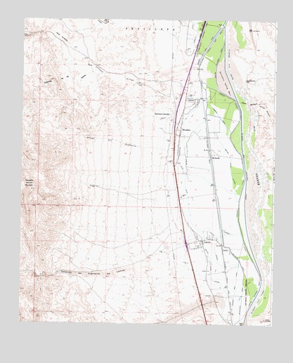
Lemitar, NM USGS Topographic Map
Click on map above to begin viewing in our Map Viewer.

This topographic map contains these locations and features:
Feature Name Type Latitude Longitude GNIS ID View Map
10028 Water WellWellN34.1992°W106.9064°925636View Map
10032 Water WellWellN34.1701°W106.9156°925634View Map
156 Lemitar InterchangeCrossingN34.1578°W106.9184°929579View Map
Arroto de AlamilloStreamN34.2151°W106.8850°900293View Map
Arroyo de la ParidaStreamN34.1270°W106.8859°897580View Map
Arroyo del PuertecitoStreamN34.1965°W106.9228°897605View Map
Arroyo del VeranitoStreamN34.1576°W106.8803°897608View Map
Barranca ColoradaAreaN34.2120°W106.9311°886082View Map
Bowling GreenLocaleN34.2256°W106.8900°886667View Map
Box Canyon DepositMineN34.1542°W106.9867°916458View Map
Caņada VivorosaStreamN34.2473°W106.9167°897738View Map
Caņoncito de la CabrasValleyN34.2301°W106.9625°904705View Map
Caņoncito de Puertecito del LemitarValleyN34.1498°W106.9078°897859View Map
Chambon LateralCanalN34.1623°W106.8911°887420View Map
Chamisal DrainCanalN34.2106°W106.9031°887423View Map
ChamizalPopulated PlaceN34.2176°W106.9136°923582View Map
Chamizal Census Designated PlaceCensusN34.2183°W106.9151°2584074View Map
Contra AcequiaCanalN34.1584°W106.9031°887799View Map
First Assembly of God ChurchChurchN34.2048°W106.9217°921071View Map
LemitarLocaleN34.1556°W106.8970°899721View Map
LemitarPopulated PlaceN34.1598°W106.9103°923619View Map
Lemitar CemeteryCemeteryN34.1600°W106.9096°931237View Map
Lemitar Census Designated PlaceCensusN34.1550°W106.9122°2584140View Map
Lemitar DitchCanalN34.1865°W106.9189°891040View Map
Lemitar Ditch LateralCanalN34.1526°W106.9064°891041View Map
Lemitar MountainsMineN34.2478°W106.9850°917423View Map
Lemitar Post OfficePost OfficeN34.1587°W106.9113°938284View Map
Lemitar Riverside DrainCanalN34.2356°W106.9031°891042View Map
Lemitar Waste LateralCanalN34.1884°W106.8967°891043View Map
McAllister DrainCanalN34.1362°W106.8903°891706View Map
McNierneyPopulated PlaceN34.1937°W106.9061°899762View Map
Midway Elementary SchoolSchoolN34.2048°W106.9217°933885View Map
Midway Volunteer Fire and RescueBuildingN34.1600°W106.9124°2658122View Map
Ojitos SpringsSpringN34.1334°W106.9811°929300View Map
Polvader DitchCanalN34.1920°W106.9223°893392View Map
PolvaderaPopulated PlaceN34.2048°W106.9217°923651View Map
Polvadera CemeteryCemeteryN34.2048°W106.9217°931235View Map
Polvadera Census Designated PlaceCensusN34.2020°W106.9172°2584183View Map
Polvadera DrainCanalN34.1509°W106.8917°893393View Map
Polvadera MountainSummitN34.1820°W106.9964°893394View Map
Polvadera Post OfficePost OfficeN34.2157°W106.9136°937789View Map
Rio Grande Pilot ChannelCanalN34.1337°W106.8825°893967View Map
Sagrada Familiar de Lemitar Church Historic SiteChurchN34.1598°W106.9103°934329View Map
San Acacia Drainage CanalCanalN34.2423°W106.9123°894393View Map
San Lorenzo ArroyoStreamN34.2278°W106.8989°923680View Map
San Lorenzo Settling BasinBasinN34.2251°W106.9006°894455View Map
Saracino LateralCanalN34.1784°W106.8920°894594View Map
Sarracino Hall Historic SiteBuildingN34.2048°W106.9217°934452View Map
Vasquez LateralCanalN34.2184°W106.8973°896106View Map

Note: Coordinates in the location and feature list above are referenced to NAD83 datum.


Copyright (C) 2008-2024 Ryan Niemi / Sunset Dynamics ... All Rights Reserved