TopoQuest Logo
Do you find TopoQuest useful?
Help keep TopoQuest running and adding new maps/features by donating!
Bitcoin:  19c7KJd3qBynnjoSw5npx9KScwjBe4ifkT
Litecoin:  LXs6TkuXGGXo1vDsWCkWVdjQX94eUKd6ui
Home View Maps Find Maps Find Places Resources & Links


San Carlos, Arizona Topographic Map

USGS Map Title: San Carlos, AZ
USGS Map MRC: 33110C4
DRG (GeoTIFF) Download: o33110c4.tif


Neighboring USGS Topographic Map Quads:


  Dourine Canyon, AZ  
33110D5
 

  Natural Corral, AZ  
33110D4
 

  Sontag Mesa, AZ  
33110D3
 

  Bucket Mountain, AZ  
33110C5
 

  San Carlos, AZ  
33110C4
 

  Mount Triplet, AZ  
33110C3
 

  Coolidge Dam, AZ  
33110B5
 

  San Carlos Reservoir, AZ  
33110B4
 

  Dewey Flat, AZ  
33110B3


Map MRC Location:

N34°
W111°
N34°
W110°
H8 H7 H6 H5 H4 H3 H2 H1
G8 G7 G6 G5 G4 G3 G2 G1
F8 F7 F6 F5 F4 F3 F2 F1
E8 E7 E6 E5 E4 E3 E2 E1
D8 D7 D6 D5 D4 D3 D2 D1
C8 C7 C6 C5 C4 C3 C2 C1
B8 B7 B6 B5 B4 B3 B2 B1
A8 A7 A6 A5 A4 A3 A2 A1
N33°
W111°
N33°
W110°

San Carlos, AZ USGS 1:24K Topographic Map Preview:
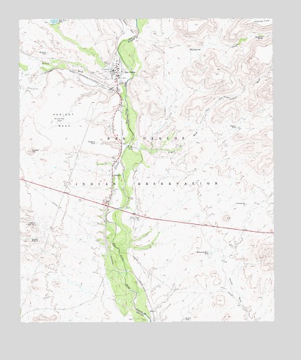
San Carlos, AZ USGS Topographic Map
Click on map above to begin viewing in our Map Viewer.

This topographic map contains these locations and features:
Feature Name Type Latitude Longitude GNIS ID View Map
Gila Community College San Carlos CampusSchoolN33.3558°W110.4591°2544757View Map
Gilson WashStreamN33.3478°W110.4487°29328View Map
Hackberry CreekStreamN33.3673°W110.4443°5471View Map
Hackberry SpringSpringN33.3677°W110.3804°5484View Map
Hollywood Bowl TankReservoirN33.2786°W110.4066°5893View Map
Hollywood WellWellN33.2984°W110.3893°5894View Map
Maltazan TankReservoirN33.3614°W110.4868°7634View Map
Naltazen DamDamN33.3614°W110.4868°22354View Map
PeridotPopulated PlaceN33.3103°W110.4554°9325View Map
Peridot Census Designated PlaceCensusN33.3016°W110.4554°2409055View Map
Peridot Flat TanksReservoirN33.3323°W110.4824°9326View Map
Peridot HillSummitN33.3206°W110.4951°9327View Map
Peridot Lutheran Elementary SchoolSchoolN33.3125°W110.4566°2544962View Map
Peridot MesaFlatN33.3339°W110.4857°9328View Map
Peridot Post OfficePost OfficeN33.2990°W110.4593°44927View Map
Peridot WellWellN33.3470°W110.4954°9330View Map
Public Health Services Indian Hospital San Carlos Service UnitHospitalN33.3538°W110.4542°22364View Map
Rice Elementary SchoolSchoolN33.3558°W110.4530°22360View Map
Saint Charles Apache Mission SchoolSchoolN33.3543°W110.4519°2544945View Map
San CarlosPopulated PlaceN33.3453°W110.4532°10812View Map
San Carlos AirportAirportN33.3723°W110.4581°45491View Map
San Carlos Apache Police DepartmentBuildingN33.3492°W110.4565°2672302View Map
San Carlos Apache Police DepartmentBuildingN33.3492°W110.4565°22367View Map
San Carlos Census Designated PlaceCensusN33.3499°W110.4654°2409250View Map
San Carlos Indian AgencyBuildingN33.3517°W110.4518°22365View Map
San Carlos Intermediate SchoolSchoolN33.3575°W110.4538°2544756View Map
San Carlos Post OfficePost OfficeN33.3540°W110.4527°44930View Map
San Carlos Secondary SchoolSchoolN33.2983°W110.4739°2545025View Map
Sawmill Tank Number OneReservoirN33.2847°W110.4951°10986View Map
Sawmill Tank Number TwoReservoirN33.2909°W110.4923°10987View Map
Sevenmile WashStreamN33.3695°W110.4429°34292View Map
Sixmile TankReservoirN33.2521°W110.4193°11383View Map
Telephone TankReservoirN33.3241°W110.4631°12231View Map
Trainer DamDamN33.3251°W110.3923°22687View Map
Trainer TankReservoirN33.3303°W110.3934°12678View Map
Triplet WashStreamN33.3237°W110.4454°12725View Map
Tufa Stone DamDamN33.3734°W110.4818°22379View Map

Note: Coordinates in the location and feature list above are referenced to NAD83 datum.


Copyright (C) 2008-2025 Ryan Niemi / Sunset Dynamics ... All Rights Reserved