TopoQuest Logo
Do you find TopoQuest useful?
Help keep TopoQuest running and adding new maps/features by donating!
Bitcoin:  19c7KJd3qBynnjoSw5npx9KScwjBe4ifkT
Litecoin:  LXs6TkuXGGXo1vDsWCkWVdjQX94eUKd6ui
Home View Maps Find Maps Find Places Resources & Links


Coolidge Dam, Arizona Topographic Map

USGS Map Title: Coolidge Dam, AZ
USGS Map MRC: 33110B5
DRG (GeoTIFF) Download: o33110b5.tif


Neighboring USGS Topographic Map Quads:


  Cutter, AZ  
33110C6
 

  Bucket Mountain, AZ  
33110C5
 

  San Carlos, AZ  
33110C4
 

  Mescal Warm Spring, AZ  
33110B6
 

  Coolidge Dam, AZ  
33110B5
 

  San Carlos Reservoir, AZ  
33110B4
 

  Christmas, AZ  
33110A6
 

  Jerusalem Mountain, AZ  
33110A5
 

  Rawhide Mountain, AZ  
33110A4


Map MRC Location:

N34°
W111°
N34°
W110°
H8 H7 H6 H5 H4 H3 H2 H1
G8 G7 G6 G5 G4 G3 G2 G1
F8 F7 F6 F5 F4 F3 F2 F1
E8 E7 E6 E5 E4 E3 E2 E1
D8 D7 D6 D5 D4 D3 D2 D1
C8 C7 C6 C5 C4 C3 C2 C1
B8 B7 B6 B5 B4 B3 B2 B1
A8 A7 A6 A5 A4 A3 A2 A1
N33°
W111°
N33°
W110°

Coolidge Dam, AZ USGS 1:24K Topographic Map Preview:
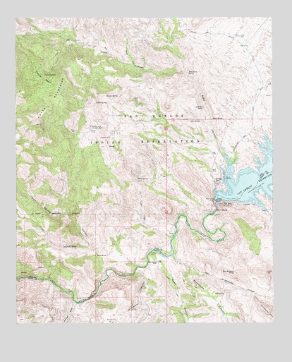
Coolidge Dam, AZ USGS Topographic Map
Click on map above to begin viewing in our Map Viewer.

This topographic map contains these locations and features:
Feature Name Type Latitude Longitude GNIS ID View Map
Anderson SpringSpringN33.2132°W110.5340°643View Map
Baker WellWellN33.2039°W110.5965°969View Map
Blue Mountain SpringSpringN33.1456°W110.5193°1718View Map
Coolidge DamDamN33.1748°W110.5276°3196View Map
Coolidge DamPopulated PlaceN33.1820°W110.5265°3197View Map
Dick SpringSpringN33.1528°W110.5862°3941View Map
Dick Spring CanyonValleyN33.1431°W110.5823°3942View Map
Dick Spring CreekStreamN33.1431°W110.5823°22329View Map
Grapevine SpringSpringN33.1567°W110.5965°5281View Map
Hawk CanyonValleyN33.1520°W110.5590°5625View Map
Hawk SpringSpringN33.1839°W110.5662°5631View Map
Hayes MountainsSummitN33.2120°W110.6087°5653View Map
Hill WellWellN33.2423°W110.5165°5819View Map
Hook and Line RanchLocaleN33.1501°W110.5570°5916View Map
Indian SpringSpringN33.2154°W110.5814°6231View Map
Jerusalem CanyonValleyN33.1467°W110.5673°6400View Map
Juniper SpringSpringN33.2182°W110.5761°6548View Map
Kidde SpringSpringN33.2084°W110.5246°6687View Map
McDougal WashStreamN33.1337°W110.5959°7827View Map
Mud SpringSpringN33.1370°W110.5245°8358View Map
Needle's Eye WildernessReserveN33.1466°W110.6207°2035219View Map
Needles EyeGapN33.1362°W110.5879°8555View Map
Poverty FlatFlatN33.1262°W110.5790°9712View Map
Rockhouse CanyonValleyN33.1526°W110.5498°10444View Map
Rockhouse MountainSummitN33.1312°W110.5040°10445View Map
Soda CanyonValleyN33.1881°W110.5212°34601View Map
Soda SpringSpringN33.2078°W110.5356°11523View Map
Standing Rock Catchment BasinReservoirN33.2048°W110.5887°11775View Map
Stockton WellWellN33.2009°W110.5795°11865View Map
Tincup BasinBasinN33.2253°W110.6120°12496View Map
Tincup SpringsSpringN33.2255°W110.6092°12497View Map
Warm SpringSpringN33.1712°W110.5282°13345View Map
Wild Horse SpringSpringN33.2278°W110.5415°13767View Map

Note: Coordinates in the location and feature list above are referenced to NAD83 datum.


Copyright (C) 2008-2024 Ryan Niemi / Sunset Dynamics ... All Rights Reserved