TopoQuest Logo
Do you find TopoQuest useful?
Help keep TopoQuest running and adding new maps/features by donating!
Bitcoin:  19c7KJd3qBynnjoSw5npx9KScwjBe4ifkT
Litecoin:  LXs6TkuXGGXo1vDsWCkWVdjQX94eUKd6ui
Home View Maps Find Maps Find Places Resources & Links


San Diego, Texas Topographic Map

USGS Map Title: San Diego, TX
USGS Map MRC: 27098G2
DRG (GeoTIFF) Download: o27098g2.tif


Neighboring USGS Topographic Map Quads:


  Rosita NE, TX  
27098H3
 

  Shaeffer Ranch, TX  
27098H2
 

  San Diego NE, TX  
27098H1
 

  Rosita SE, TX  
27098G3
 

  San Diego, TX  
27098G2
 

  Alice North, TX  
27098G1
 

  Benavides NE, TX  
27098F3
 

  Ben Bolt NW, TX  
27098F2
 

  Alice South, TX  
27098F1


Map MRC Location:

N28°
W99°
N28°
W98°
H8 H7 H6 H5 H4 H3 H2 H1
G8 G7 G6 G5 G4 G3 G2 G1
F8 F7 F6 F5 F4 F3 F2 F1
E8 E7 E6 E5 E4 E3 E2 E1
D8 D7 D6 D5 D4 D3 D2 D1
C8 C7 C6 C5 C4 C3 C2 C1
B8 B7 B6 B5 B4 B3 B2 B1
A8 A7 A6 A5 A4 A3 A2 A1
N27°
W99°
N27°
W98°

San Diego, TX USGS 1:24K Topographic Map Preview:
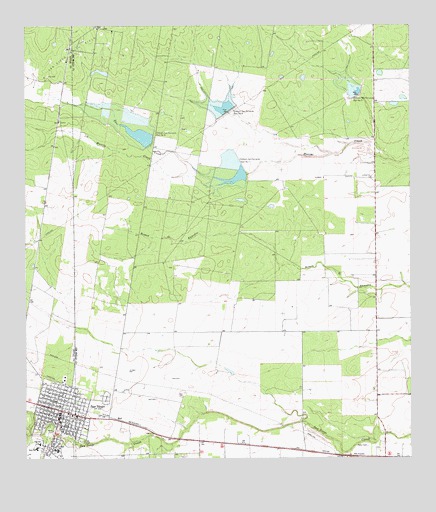
San Diego, TX USGS Topographic Map
Click on map above to begin viewing in our Map Viewer.

This topographic map contains these locations and features:
Feature Name Type Latitude Longitude GNIS ID View Map
Archie Parr Elementary SchoolSchoolN27.7536°W98.2465°1343620View Map
Bernarda Jaime Junior High SchoolSchoolN27.7534°W98.2469°2003955View Map
Chiltipin-San Fernando Dam Number 6DamN27.8411°W98.2089°1332747View Map
Chiltipin-San Fernando Dam Number 7DamN27.8322°W98.1778°1332748View Map
Chiltipin-San Fernando Dam Number 8DamN27.8506°W98.1836°1332749View Map
Chiltipin-San Fernando Dam Number 9DamN27.8553°W98.1417°1332750View Map
City of San DiegoCivilN27.7609°W98.2389°2411783View Map
City of San Diego Emergency Medical ServiceBuildingN27.7610°W98.2397°2655718View Map
Collins - Parr Elementary SchoolSchoolN27.7532°W98.2466°2003956View Map
County Road 111 ColoniaPopulated PlaceN27.7553°W98.2372°2010191View Map
Duval County Constable's Office Precinct 1BuildingN27.7606°W98.2392°2750580View Map
Duval County JailBuildingN27.7627°W98.2354°2738779View Map
Duval County Sheriff's OfficeBuildingN27.7627°W98.2355°2335072View Map
Duval County Sheriff's OfficeBuildingN27.7620°W98.2359°2335154View Map
Highland Addition ColoniaPopulated PlaceN27.7722°W98.2283°2011471View Map
KUKA-FM (San Diego)TowerN27.7597°W98.1808°1388080View Map
Loma Linda East Census Designated PlaceCensusN27.7663°W98.1942°2408120View Map
Loma Linda East ColoniaPopulated PlaceN27.7622°W98.1992°2011444View Map
Mi Tierra ColoniaPopulated PlaceN27.7753°W98.2364°2010149View Map
MuilPopulated PlaceN27.7606°W98.2170°1378716View Map
Rosita CreekStreamN27.7575°W98.2483°1345602View Map
San DiegoPopulated PlaceN27.7639°W98.2389°1346324View Map
San Diego City HallBuildingN27.7606°W98.2392°2753166View Map
San Diego Fire DepartmentBuildingN27.7610°W98.2397°2334308View Map
San Diego Oil FieldOilfieldN27.8672°W98.2356°1346326View Map
San Diego Police DepartmentBuildingN27.7606°W98.2391°2335150View Map
San Diego Post OfficePost OfficeN27.7645°W98.2368°2731774View Map
Soil Conservation Service 6 DamDamN27.8420°W98.2103°1861924View Map
Soil Conservation Service 7 DamDamN27.8320°W98.1786°1861926View Map
Soil Conservation Service 8 DamDamN27.8503°W98.1853°1861928View Map
Soil Conservation Service 9 DamDamN27.8553°W98.1419°1861930View Map
Soil Conservation Service Site 6 ReservoirReservoirN27.8420°W98.2103°1861925View Map
Soil Conservation Service Site 7 ReservoirReservoirN27.8320°W98.1786°1861927View Map
Soil Conservation Service Site 8 ReservoirReservoirN27.8503°W98.1853°1861929View Map
Soil Conservation Service Site 9 ReservoirReservoirN27.8553°W98.1419°1861931View Map
SpringfieldPopulated PlaceN27.7520°W98.1945°2034931View Map
Toro CreekStreamN27.8309°W98.1822°1348653View Map

Note: Coordinates in the location and feature list above are referenced to NAD83 datum.


Copyright (C) 2008-2025 Ryan Niemi / Sunset Dynamics ... All Rights Reserved