TopoQuest Logo
Do you find TopoQuest useful?
Help keep TopoQuest running and adding new maps/features by donating!
Bitcoin:  19c7KJd3qBynnjoSw5npx9KScwjBe4ifkT
Litecoin:  LXs6TkuXGGXo1vDsWCkWVdjQX94eUKd6ui
Home View Maps Find Maps Find Places Resources & Links


San Geronimo, California Topographic Map

USGS Map Title: San Geronimo, CA
USGS Map MRC: 38122A6
DRG (GeoTIFF) Download: o38122a6.tif


Neighboring USGS Topographic Map Quads:


  Point Reyes NE, CA  
38122B7
 

  Petaluma, CA  
38122B6
 

  Petaluma River, CA  
38122B5
 

  Inverness, CA  
38122A7
 

  San Geronimo, CA  
38122A6
 

  Novato, CA  
38122A5
 

  Double Point, CA  
37122H7
 

  Bolinas, CA  
37122H6
 

  San Rafael, CA  
37122H5


Map MRC Location:

N39°
W123°
N39°
W122°
H8 H7 H6 H5 H4 H3 H2 H1
G8 G7 G6 G5 G4 G3 G2 G1
F8 F7 F6 F5 F4 F3 F2 F1
E8 E7 E6 E5 E4 E3 E2 E1
D8 D7 D6 D5 D4 D3 D2 D1
C8 C7 C6 C5 C4 C3 C2 C1
B8 B7 B6 B5 B4 B3 B2 B1
A8 A7 A6 A5 A4 A3 A2 A1
N38°
W123°
N38°
W122°

San Geronimo, CA USGS 1:24K Topographic Map Preview:
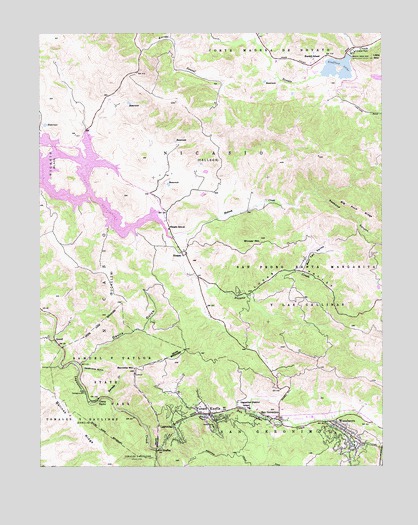
San Geronimo, CA USGS Topographic Map
Click on map above to begin viewing in our Map Viewer.

This topographic map contains these locations and features:
Feature Name Type Latitude Longitude GNIS ID View Map
Barnabe CreekStreamN38.0196°W122.7258°218681View Map
Barnabe MountainSummitN38.0277°W122.7161°218682View Map
Barnabe TrailTrailN38.0258°W122.7214°1800728View Map
Bills TrailTrailN38.0355°W122.7150°1800729View Map
Bolinas Ridge Fire TrailTrailN38.0108°W122.7372°1800730View Map
Bowman CanyonValleyN38.1233°W122.6253°219721View Map
Bull Tail ValleyValleyN38.0569°W122.6555°220126View Map
Burdell SchoolSchoolN38.1169°W122.6500°220179View Map
Camp TaylorLocaleN38.0196°W122.7297°220491View Map
Camp Taylor Post Office (historical)Post OfficeN38.0196°W122.7297°2026846View Map
Canada PomponioValleyN38.1208°W122.7136°1702863View Map
Crystal SpringsSpringN38.0138°W122.7172°1800733View Map
Deadmans GulchValleyN38.0280°W122.7358°222132View Map
Deer PointSummitN38.0419°W122.7264°1800734View Map
Devils GulchValleyN38.0296°W122.7358°222308View Map
Devils Gulch CreekStreamN38.0294°W122.7367°1800736View Map
Devils Gulch Horse CampLocaleN38.0330°W122.7325°1808938View Map
Forest KnollsPopulated PlaceN38.0152°W122.6886°223678View Map
Forest Knolls Post OfficePost OfficeN38.0151°W122.6896°1800738View Map
Halleck CreekStreamN38.0674°W122.7036°224814View Map
Indian Tree PreserveParkN38.0924°W122.6442°1800742View Map
Indian Valley Golf CourseLocaleN38.1094°W122.6372°1800743View Map
Irving (historical)Populated PlaceN38.0169°W122.7244°1702855View Map
Irving CreekStreamN38.0166°W122.7239°1800744View Map
Irving Group Picnic AreaLocaleN38.0166°W122.7230°1800745View Map
JewellPopulated PlaceN38.0366°W122.7458°1658861View Map
Lafranchi QuarryMineN38.0681°W122.6967°2678217View Map
LagunitasPopulated PlaceN38.0113°W122.7022°1658927View Map
Lagunitas Post OfficePost OfficeN38.0143°W122.6973°1800751View Map
Lagunitas SchoolSchoolN38.0176°W122.6755°226789View Map
Lagunitas-Forest Knolls Census Designated PlaceCensusN38.0180°W122.6913°2408528View Map
Little MountainSummitN38.1174°W122.6264°1658975View Map
Lower CampgroundLocaleN38.0194°W122.7344°1800755View Map
Lucas ValleyValleyN38.0588°W122.6989°227812View Map
Madrone Group Area CampgroundLocaleN38.0196°W122.7322°1800759View Map
Mailliard (historical)Populated PlaceN38.0066°W122.6341°1702857View Map
Marin CountyCivilN38.0552°W122.7489°277285View Map
Marin County Fire Department Woodacre StationBuildingN38.0073°W122.6350°2624438View Map
Maurice Thorner Memorial PreserveParkN38.0177°W122.6683°1800766View Map
NicasioPopulated PlaceN38.0616°W122.6986°1659226View Map
Nicasio Census Designated PlaceCensusN38.0606°W122.7008°2628764View Map
Nicasio Elementary SchoolSchoolN38.0684°W122.7038°229537View Map
Nicasio Post OfficePost OfficeN38.0622°W122.6985°1800770View Map
Nicasio ReservoirReservoirN38.0783°W122.7438°229536View Map
Nicasio Volunteer Fire Protection DistrictBuildingN38.0623°W122.6980°2624446View Map
North Creek TrailTrailN38.0227°W122.7347°1800771View Map
Novato Creek DamDamN38.1183°W122.6375°229803View Map
Ox TrailTrailN38.0252°W122.7375°1800775View Map
Pacheco School (historical)SchoolN38.0938°W122.7364°1702862View Map
Pioneer Tree TrailTrailN38.0155°W122.7286°1800777View Map
Redwood CanyonValleyN38.0785°W122.6497°231415View Map
Redwood Grove Picnic AreaLocaleN38.0180°W122.7328°1800778View Map
Ridge TrailTrailN38.0208°W122.7133°1800779View Map
Roys Redwoods PreserveParkN38.0221°W122.6539°1800780View Map
Samuel P Taylor State Park OfficeBuildingN38.0191°W122.7303°1800782View Map
Samuel P. Taylor State ParkParkN38.0258°W122.7278°232358View Map
San GeronimoCivilN38.0066°W122.6658°232398View Map
San GeronimoPopulated PlaceN38.0133°W122.6639°232399View Map
San Geronimo Census Designated PlaceCensusN38.0067°W122.6633°2409255View Map
San Geronimo CreekStreamN38.0046°W122.7089°232400View Map
San Geronimo National Golf CourseLocaleN38.0135°W122.6569°1800784View Map
San Geronimo Post OfficePost OfficeN38.0142°W122.6668°1800785View Map
San Geronimo Valley Branch Marin County Free LibraryBuildingN38.0171°W122.6755°1800786View Map
San Geronimo Valley Elementary SchoolSchoolN38.0163°W122.6717°1800787View Map
ShafterPopulated PlaceN38.0044°W122.7086°252791View Map
Shafter BridgeBridgeN38.0046°W122.7086°1800791View Map
Shroyer MountainSummitN38.0652°W122.6700°233068View Map
Skywalker Ranch Fire BrigadeBuildingN38.0593°W122.6545°2624445View Map
Stafford County ParkParkN38.1138°W122.6500°1800793View Map
Stafford LakeReservoirN38.1139°W122.6437°235342View Map
Stairstep Falls TrailTrailN38.0338°W122.7225°1800794View Map
Sunset CorralLocaleN38.1049°W122.6403°1800795View Map
Taylor CemeteryCemeteryN38.0277°W122.7344°1808965View Map
Taylorville (historical)Populated PlaceN38.0291°W122.7408°1702866View Map
Tocaloma School (historical)SchoolN38.0383°W122.7453°1702867View Map
Upper CampgroundLocaleN38.0216°W122.7355°1800801View Map
Wildcat CanyonValleyN38.0174°W122.7322°1800804View Map
WoodacrePopulated PlaceN38.0127°W122.6453°1652657View Map
Woodacre Census Designated PlaceCensusN38.0052°W122.6383°2409620View Map
Woodacre Post OfficePost OfficeN38.0127°W122.6444°1800805View Map

Note: Coordinates in the location and feature list above are referenced to NAD83 datum.


Copyright (C) 2008-2024 Ryan Niemi / Sunset Dynamics ... All Rights Reserved