TopoQuest Logo
Do you find TopoQuest useful?
Help keep TopoQuest running and adding new maps/features by donating!
Bitcoin:  19c7KJd3qBynnjoSw5npx9KScwjBe4ifkT
Litecoin:  LXs6TkuXGGXo1vDsWCkWVdjQX94eUKd6ui
Home View Maps Find Maps Find Places Resources & Links


Sanibel, Florida Topographic Map

USGS Map Title: Sanibel, FL
USGS Map MRC: 26082D1
DRG (GeoTIFF) Download: o26082d1.tif


Neighboring USGS Topographic Map Quads:


  Captiva, FL  
26082E2
 

  Pine Island Center, FL  
26082E1
 

  Fort Myers SW, FL  
26081E8
 

  Wulfert, FL  
26082D2
 

  Sanibel, FL  
26082D1
 

  Fort Myers Beach, FL  
26081D8


Map MRC Location:

N27°
W83°
N27°
W82°
H8 H7 H6 H5 H4 H3 H2 H1
G8 G7 G6 G5 G4 G3 G2 G1
F8 F7 F6 F5 F4 F3 F2 F1
E8 E7 E6 E5 E4 E3 E2 E1
D8 D7 D6 D5 D4 D3 D2 D1
C8 C7 C6 C5 C4 C3 C2 C1
B8 B7 B6 B5 B4 B3 B2 B1
A8 A7 A6 A5 A4 A3 A2 A1
N26°
W83°
N26°
W82°

Sanibel, FL USGS 1:24K Topographic Map Preview:
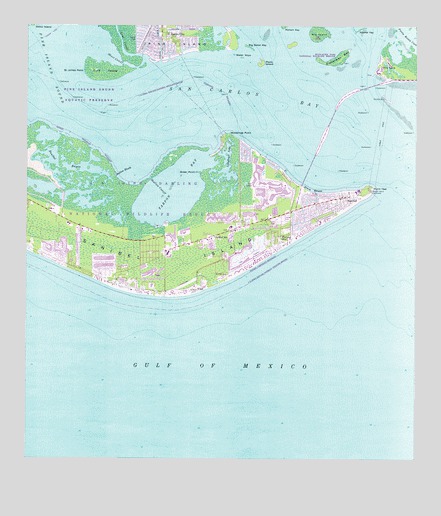
Sanibel, FL USGS Topographic Map
Click on map above to begin viewing in our Map Viewer.

This topographic map contains these locations and features:
Feature Name Type Latitude Longitude GNIS ID View Map
Baileys CenterLocaleN26.4295°W82.0748°296235View Map
Big IslandIslandN26.4992°W82.0315°278697View Map
Big Sister KeyIslandN26.4942°W82.0537°278743View Map
Bigelow Shopping CenterLocaleN26.4087°W82.0859°296238View Map
City of SanibelCivilN26.4532°W82.0999°2405420View Map
Dixie BeachBeachN26.4526°W82.0295°281603View Map
First Baptist Church SanibelChurchN26.4504°W82.0262°302202View Map
Fisherman KeyIslandN26.4906°W82.0262°294013View Map
Green PointCapeN26.4581°W82.0706°283392View Map
Gulfside Park Historic CemeteryCemeteryN26.4280°W82.0645°290639View Map
Henley CanalCanalN26.4987°W82.0829°283910View Map
J N "Ding" Darling WildernessReserveN26.4607°W82.1032°2035556View Map
J N Ding Darling National Wildlife RefugeParkN26.4606°W82.1116°307114View Map
James Cipriani HeliportAirportN26.4373°W82.0676°309878View Map
Knapps PointCapeN26.4234°W82.0693°307693View Map
Ladyfinger LakeLakeN26.4588°W82.0614°285204View Map
Lee County Emergency Medical ServicesBuildingN26.4377°W82.0779°2661783View Map
Long CutoffChannelN26.4959°W82.0948°285988View Map
McIntyre CreekStreamN26.4645°W82.1037°307672View Map
Periwinkle Place Shopping CenterLocaleN26.4309°W82.0748°296236View Map
Phillips CanalCanalN26.4998°W82.0751°288767View Map
Picnic IslandIslandN26.4890°W82.0493°307671View Map
Plaza CentralLocaleN26.3851°W82.0734°296234View Map
Point YbelCapeN26.4540°W82.0137°289136View Map
Punta RassaPopulated PlaceN26.4879°W82.0123°289383View Map
Punta Rassa CoveBayN26.4964°W82.0020°277652View Map
Saint James CityPopulated PlaceN26.4976°W82.0784°290196View Map
Saint James City Mobile Home ParkPopulated PlaceN26.4979°W82.0823°2452243View Map
Saint James PointCapeN26.4876°W82.1065°290198View Map
San Carlos BayBayN26.4836°W82.0407°290472View Map
SanibelPopulated PlaceN26.4490°W82.0223°290637View Map
Sanibel BayouLakeN26.4616°W82.1182°290638View Map
Sanibel BayousBayN26.4616°W82.1182°297335View Map
Sanibel Community ChurchChurchN26.4504°W82.0262°307619View Map
Sanibel Congregational United Church of ChristChurchN26.4448°W82.0331°302201View Map
Sanibel Fire Department Station 171BuildingN26.4378°W82.0779°2131563View Map
Sanibel IslandIslandN26.4404°W82.1137°290640View Map
Sanibel Island CausewayBridgeN26.4767°W82.0254°298923View Map
Sanibel Island LighthouseLocaleN26.4531°W82.0143°290641View Map
Sanibel Police DepartmentBuildingN26.4407°W82.0737°2333610View Map
Sanibel Post OfficePost OfficeN26.4364°W82.0807°2768172View Map
Sanibel SchoolSchoolN26.4395°W82.0643°290642View Map
Shallow CutoffChannelN26.4562°W82.0851°290920View Map
Shallow MouthBayN26.4569°W82.0969°290921View Map
Shangri La Mobile Home ParkPopulated PlaceN26.4978°W82.0823°2452245View Map
Short CutoffChannelN26.4895°W82.0929°291085View Map
Sister KeysIslandN26.4923°W82.0587°291177View Map
Tahitian Garden Shopping CenterLocaleN26.4420°W82.0581°296237View Map
Tarpon BayBayN26.4528°W82.0778°292036View Map
Tropic Isles Baptist ChurchChurchN26.4420°W82.0373°307618View Map
Woodrings PointCapeN26.4692°W82.0598°293516View Map
YbelPopulated PlaceN26.4245°W82.0709°293575View Map
York IslandIslandN26.4876°W82.1006°293598View Map

Note: Coordinates in the location and feature list above are referenced to NAD83 datum.


Copyright (C) 2008-2024 Ryan Niemi / Sunset Dynamics ... All Rights Reserved