TopoQuest Logo
Do you find TopoQuest useful?
Help keep TopoQuest running and adding new maps/features by donating!
Bitcoin:  19c7KJd3qBynnjoSw5npx9KScwjBe4ifkT
Litecoin:  LXs6TkuXGGXo1vDsWCkWVdjQX94eUKd6ui
Home View Maps Find Maps Find Places Resources & Links


Santa Rosa, Texas Topographic Map

USGS Map Title: Santa Rosa, TX
USGS Map MRC: 26097C7
DRG (GeoTIFF) Download: o26097c7.tif


Neighboring USGS Topographic Map Quads:


  Lasara, TX  
26097D8
 

  Raymondville, TX  
26097D7
 

  San Perlita South, TX  
26097D6
 

  Edcouch, TX  
26097C8
 

  Santa Rosa, TX  
26097C7
 

  Willamar SW, TX  
26097C6
 

  Mercedes, TX  
26097B8
 

  La Feria, TX  
26097B7
 

  Harlingen, TX  
26097B6


Map MRC Location:

N27°
W98°
N27°
W97°
H8 H7 H6 H5 H4 H3 H2 H1
G8 G7 G6 G5 G4 G3 G2 G1
F8 F7 F6 F5 F4 F3 F2 F1
E8 E7 E6 E5 E4 E3 E2 E1
D8 D7 D6 D5 D4 D3 D2 D1
C8 C7 C6 C5 C4 C3 C2 C1
B8 B7 B6 B5 B4 B3 B2 B1
A8 A7 A6 A5 A4 A3 A2 A1
N26°
W98°
N26°
W97°

Santa Rosa, TX USGS 1:24K Topographic Map Preview:
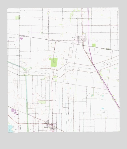
Santa Rosa, TX USGS Topographic Map
Click on map above to begin viewing in our Map Viewer.

This topographic map contains these locations and features:
Feature Name Type Latitude Longitude GNIS ID View Map
East Cantu Road ColoniaPopulated PlaceN26.2792°W97.8442°2010346View Map
El Azadon CemeteryCemeteryN26.3209°W97.8572°1335157View Map
El Nogal ColoniaPopulated PlaceN26.2584°W97.8153°2010247View Map
Guadalupe CemeteryCemeteryN26.3392°W97.8000°1337059View Map
Hugh Terry ColoniaPopulated PlaceN26.3734°W97.7822°2010634View Map
La Kinina ColoniaPopulated PlaceN26.2515°W97.8072°2010276View Map
Las Palomas Wildlife Management Area - Frederick UnitParkN26.3676°W97.8044°2028965View Map
Las Palomas Wildlife Management Area - Longoria UnitParkN26.3209°W97.8242°2028969View Map
North FloodwayBasinN26.3215°W97.7569°1342726View Map
S and C ColoniaPopulated PlaceN26.3642°W97.7903°2010639View Map
San Rafael CemeteryCemeteryN26.2695°W97.7667°1346466View Map
Santa Rita CemeteryCemeteryN26.3437°W97.8253°1346664View Map
Santa RosaPopulated PlaceN26.2567°W97.8250°1346669View Map
Santa Rosa Elementary SchoolSchoolN26.2530°W97.8247°2434308View Map
Santa Rosa High SchoolSchoolN26.2530°W97.8247°2434499View Map
Santa Rosa Middle SchoolSchoolN26.2530°W97.8247°2434484View Map
Santa Rosa Number 5 ColoniaPopulated PlaceN26.2584°W97.8214°2010215View Map
Santa Rosa Number 9 ColoniaPopulated PlaceN26.2604°W97.8342°2010217View Map
Santa Rosa Police DepartmentBuildingN26.2581°W97.8293°2335055View Map
Santa Rosa Post OfficePost OfficeN26.2559°W97.8250°2732251View Map
Santa Rosa Volunteer Fire DepartmentBuildingN26.2573°W97.8287°2334496View Map
SebastianPopulated PlaceN26.3428°W97.7903°1346856View Map
Sebastian Census Designated PlaceCensusN26.3454°W97.7964°2409298View Map
Sebastian Elementary SchoolSchoolN26.3474°W97.7952°2434388View Map
Tierra BonitaPopulated PlaceN26.2715°W97.8258°1852772View Map
Tierra Bonita Census Designated PlaceCensusN26.2727°W97.8276°2409319View Map
Tierra Bonita ColoniaPopulated PlaceN26.2684°W97.8242°2010227View Map
Tierra Bonita Number 2 ColoniaPopulated PlaceN26.2715°W97.8172°2010228View Map
Town of Santa RosaCivilN26.2561°W97.8253°2413259View Map
Willacy CanalCanalN26.2548°W97.8533°1376801View Map
YznagaPopulated PlaceN26.3165°W97.8136°1852784View Map
Yznaga Census Designated PlaceCensusN26.3188°W97.8153°2409640View Map
Yznaga Number 1 ColoniaPopulated PlaceN26.3103°W97.8292°2010244View Map
Yznaga Number 2 ColoniaPopulated PlaceN26.3284°W97.8022°2010185View Map
Zapata RanchPopulated PlaceN26.3570°W97.8292°1852785View Map
Zapata Ranch Census Designated PlaceCensusN26.3570°W97.8243°2409642View Map
Zapata Ranch ColoniaPopulated PlaceN26.3565°W97.8303°2010642View Map

Note: Coordinates in the location and feature list above are referenced to NAD83 datum.


Copyright (C) 2008-2024 Ryan Niemi / Sunset Dynamics ... All Rights Reserved