TopoQuest Logo
Do you find TopoQuest useful?
Help keep TopoQuest running and adding new maps/features by donating!
Bitcoin:  19c7KJd3qBynnjoSw5npx9KScwjBe4ifkT
Litecoin:  LXs6TkuXGGXo1vDsWCkWVdjQX94eUKd6ui
Home View Maps Find Maps Find Places Resources & Links


Santee Point, South Carolina Topographic Map

USGS Map Title: Santee Point, SC
USGS Map MRC: 33079B2
DRG (GeoTIFF) Download: o33079b2.tif


Neighboring USGS Topographic Map Quads:


  Georgetown South, SC  
33079C3
 

  North Island, SC  
33079C2


  Minim Island, SC  
33079B3
 

  Santee Point, SC  
33079B2


  Cape Romain, SC  
33079A3


Map MRC Location:

N34°
W80°
N34°
W79°
H8 H7 H6 H5 H4 H3 H2 H1
G8 G7 G6 G5 G4 G3 G2 G1
F8 F7 F6 F5 F4 F3 F2 F1
E8 E7 E6 E5 E4 E3 E2 E1
D8 D7 D6 D5 D4 D3 D2 D1
C8 C7 C6 C5 C4 C3 C2 C1
B8 B7 B6 B5 B4 B3 B2 B1
A8 A7 A6 A5 A4 A3 A2 A1
N33°
W80°
N33°
W79°

Santee Point, SC USGS 1:24K Topographic Map Preview:
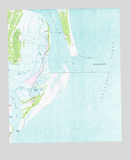
Santee Point, SC USGS Topographic Map
Click on map above to begin viewing in our Map Viewer.

This topographic map contains these locations and features:
Feature Name Type Latitude Longitude GNIS ID View Map
Beach CreekStreamN33.1738°W79.2431°1229383View Map
Bird Bank CreekStreamN33.1388°W79.2351°1229427View Map
Bottle ChannelChannelN33.1999°W79.1623°1232266View Map
Cape San RomanCapeN33.2071°W79.1762°1232280View Map
Cat IslandIslandN33.2191°W79.2384°1247183View Map
Cat Island Church (historical)ChurchN33.2079°W79.2481°1232284View Map
Cat Island PlantationLocaleN33.2021°W79.2437°1247184View Map
East BankBarN33.1563°W79.1384°1228027View Map
Fishing BankBarN33.2063°W79.1842°1232319View Map
Georgetown LighthouseBuildingN33.2224°W79.1848°1232333View Map
Lagoon CreekGutN33.2132°W79.2153°1229893View Map
Manuels School (historical)SchoolN33.2091°W79.2492°1232389View Map
Mosquito CreekLakeN33.1870°W79.2211°1249533View Map
Mosquito Creek CanalCanalN33.1993°W79.2128°1228031View Map
Mother Norton ShoalBarN33.2082°W79.1909°1228029View Map
North BreakersBarN33.1710°W79.1581°1232416View Map
North Santee BayBayN33.1643°W79.2445°1230110View Map
North Santee InletChannelN33.1377°W79.2426°1232524View Map
North Santee RiverStreamN33.1402°W79.2426°1230111View Map
Pine RidgeRidgeN33.1592°W79.2239°1230168View Map
Pine RidgeRidgeN33.1668°W79.2242°1230169View Map
Pine Ridge PondLakeN33.1637°W79.2253°1230170View Map
QuarantinePopulated PlaceN33.2296°W79.2042°1231696View Map
Rockfish CanalCanalN33.2152°W79.2223°1228032View Map
Sand Creek BasinBasinN33.1754°W79.2137°1230292View Map
Sand IslandIslandN33.1841°W79.1875°1228028View Map
Santee PointCapeN33.1377°W79.2398°1230302View Map
Slue Channel (historical)ChannelN33.2143°W79.1770°1232478View Map
South BreakersBarN33.1543°W79.1664°1232479View Map
South IslandIslandN33.1949°W79.2103°1230347View Map
Wheeler BasinBasinN33.1746°W79.2195°1230483View Map
Winyah Bay EntranceChannelN33.1982°W79.1489°1251481View Map
Yawkey-South Island ReserveParkN33.2254°W79.2220°1232513View Map

Note: Coordinates in the location and feature list above are referenced to NAD83 datum.


Copyright (C) 2008-2025 Ryan Niemi / Sunset Dynamics ... All Rights Reserved