TopoQuest Logo
Do you find TopoQuest useful?
Help keep TopoQuest running and adding new maps/features by donating!
Bitcoin:  19c7KJd3qBynnjoSw5npx9KScwjBe4ifkT
Litecoin:  LXs6TkuXGGXo1vDsWCkWVdjQX94eUKd6ui
Home View Maps Find Maps Find Places Resources & Links


Minim Island, South Carolina Topographic Map

USGS Map Title: Minim Island, SC
USGS Map MRC: 33079B3
DRG (GeoTIFF) Download: o33079b3.tif


Neighboring USGS Topographic Map Quads:


  Kilsock Island, SC  
33079C4
 

  Georgetown South, SC  
33079C3
 

  North Island, SC  
33079C2
 

  South Santee, SC  
33079B4
 

  Minim Island, SC  
33079B3
 

  Santee Point, SC  
33079B2
 

  McClellanville, SC  
33079A4
 

  Cape Romain, SC  
33079A3


Map MRC Location:

N34°
W80°
N34°
W79°
H8 H7 H6 H5 H4 H3 H2 H1
G8 G7 G6 G5 G4 G3 G2 G1
F8 F7 F6 F5 F4 F3 F2 F1
E8 E7 E6 E5 E4 E3 E2 E1
D8 D7 D6 D5 D4 D3 D2 D1
C8 C7 C6 C5 C4 C3 C2 C1
B8 B7 B6 B5 B4 B3 B2 B1
A8 A7 A6 A5 A4 A3 A2 A1
N33°
W80°
N33°
W79°

Minim Island, SC USGS 1:24K Topographic Map Preview:
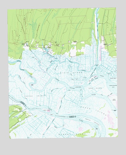
Minim Island, SC USGS Topographic Map
Click on map above to begin viewing in our Map Viewer.

This topographic map contains these locations and features:
Feature Name Type Latitude Longitude GNIS ID View Map
Alligator CreekGutN33.1360°W79.3156°1229346View Map
Annandale PlantationLocaleN33.2171°W79.2973°1244888View Map
Atchison CreekGutN33.1699°W79.3253°1229362View Map
Bethel ChurchChurchN33.2174°W79.3209°1246777View Map
Big Duck CreekStreamN33.1746°W79.2712°1229419View Map
Black Out PlantationLocaleN33.2232°W79.2676°1235298View Map
Bluff CreekStreamN33.1993°W79.3409°1229435View Map
Brown IslandIslandN33.1524°W79.3314°1229461View Map
Cane CreekGutN33.1657°W79.2584°1229514View Map
Cane IslandIslandN33.1602°W79.2534°1247144View Map
Cat Island PlantationLocaleN33.2149°W79.2603°1229528View Map
Cedar IslandIslandN33.1507°W79.2667°1229536View Map
Cork CreekStreamN33.1974°W79.3159°1229396View Map
Crow IslandIslandN33.1746°W79.2712°1229609View Map
Doar PlantationLocaleN33.2149°W79.3537°1247531View Map
Doar PointCapeN33.1774°W79.3501°1229639View Map
Drum IslandsIslandN33.1352°W79.2745°1229651View Map
Duck CreekStreamN33.1785°W79.2592°1229660View Map
Estherville Minim Creek CanalCanalN33.2268°W79.2712°1229690View Map
Fourmile Creek CanalCanalN33.1627°W79.3137°1247819View Map
Goat IslandIslandN33.1482°W79.3256°1229734View Map
Grace IslandIslandN33.1413°W79.2798°1229743View Map
Hide Out PlantationLocaleN33.2071°W79.3295°1235300View Map
Kinloch CreekStreamN33.1891°W79.3309°1229889View Map
Kinloch IslandIslandN33.1807°W79.2851°1229890View Map
Kinloch PlantationLocaleN33.2129°W79.3301°1246260View Map
Little Crow IslandIslandN33.1824°W79.2789°1229916View Map
Little Duck CreekStreamN33.1807°W79.2851°1229918View Map
Minim CreekGutN33.2018°W79.3081°1246693View Map
Minim IslandIslandN33.1882°W79.3037°1230027View Map
Pleasant CreekStreamN33.1557°W79.3414°1230179View Map
Pleasant Meadow CreekStreamN33.2002°W79.3198°1230183View Map
Ravenel PlantationLocaleN33.2066°W79.3131°1235301View Map
Rice Hope ChurchChurchN33.2182°W79.3542°1230238View Map
Rice Hope PlantationLocaleN33.2163°W79.3553°1250361View Map
Richfield School (historical)SchoolN33.2182°W79.3270°1232441View Map
Saint James ChurchChurchN33.2132°W79.2598°1232457View Map
Sand CreekStreamN33.1979°W79.3028°1229593View Map
Santee Coastal ReserveParkN33.1543°W79.2742°1232472View Map
Santee Gun ClubLocaleN33.1541°W79.3620°1253223View Map
Sixmile CreekStreamN33.1718°W79.3484°1250911View Map
Sturgeon IslandIslandN33.1518°W79.2509°1230378View Map
White Oak CreekStreamN33.2013°W79.3623°1230489View Map

Note: Coordinates in the location and feature list above are referenced to NAD83 datum.


Copyright (C) 2008-2024 Ryan Niemi / Sunset Dynamics ... All Rights Reserved