TopoQuest Logo
Do you find TopoQuest useful?
Help keep TopoQuest running and adding new maps/features by donating!
Bitcoin:  19c7KJd3qBynnjoSw5npx9KScwjBe4ifkT
Litecoin:  LXs6TkuXGGXo1vDsWCkWVdjQX94eUKd6ui
Home View Maps Find Maps Find Places Resources & Links


Santos Peak, New Mexico Topographic Map

USGS Map Title: Santos Peak, NM
USGS Map MRC: 36107E4
DRG (GeoTIFF) Download: o36107e4.tif


Neighboring USGS Topographic Map Quads:


  Delgadita Mesa, NM  
36107F5
 

  Fourmile Canyon, NM  
36107F4
 

  Gobernador, NM  
36107F3
 

  Gould Pass, NM  
36107E5
 

  Santos Peak, NM  
36107E4
 

  Vigas Canyon, NM  
36107E3
 

  Smouse Mesa, NM  
36107D5
 

  Gonzales Mesa, NM  
36107D4
 

  Lapis Point, NM  
36107D3


Map MRC Location:

N37°
W108°
N37°
W107°
H8 H7 H6 H5 H4 H3 H2 H1
G8 G7 G6 G5 G4 G3 G2 G1
F8 F7 F6 F5 F4 F3 F2 F1
E8 E7 E6 E5 E4 E3 E2 E1
D8 D7 D6 D5 D4 D3 D2 D1
C8 C7 C6 C5 C4 C3 C2 C1
B8 B7 B6 B5 B4 B3 B2 B1
A8 A7 A6 A5 A4 A3 A2 A1
N36°
W108°
N36°
W107°

Santos Peak, NM USGS 1:24K Topographic Map Preview:
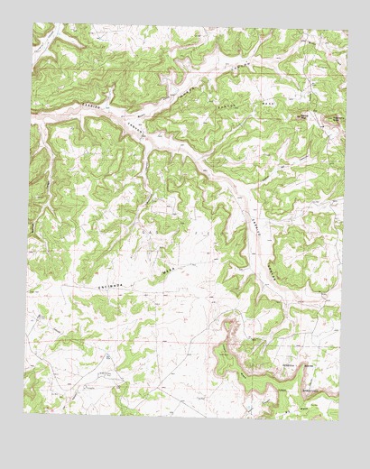
Santos Peak, NM USGS Topographic Map
Click on map above to begin viewing in our Map Viewer.

This topographic map contains these locations and features:
Feature Name Type Latitude Longitude GNIS ID View Map
Albert MesaSummitN36.5200°W107.4217°903063View Map
Camp ErcanLocaleN36.5133°W107.4684°904317View Map
Caņon de CaminoValleyN36.5703°W107.4150°904572View Map
Lowry 3 Water WellWellN36.5236°W107.4987°926514View Map
Lowry 4 Water WellWellN36.5228°W107.4989°926513View Map
Lowry 5 Water WellWellN36.5311°W107.4942°926516View Map
Lowry CampLocaleN36.5306°W107.4978°914303View Map
Magdalena ButteSummitN36.5967°W107.3809°908354View Map
Martinez CanyonValleyN36.5867°W107.4514°908434View Map
Muņoz CanyonValleyN36.5953°W107.4648°908985View Map
Muņoz CreekStreamN36.5953°W107.4648°908986View Map
Rincon LargoValleyN36.5945°W107.4959°910200View Map
Santos MesaSummitN36.5967°W107.4328°910811View Map
Santos PeakSummitN36.5970°W107.3934°910813View Map

Note: Coordinates in the location and feature list above are referenced to NAD83 datum.


Copyright (C) 2008-2024 Ryan Niemi / Sunset Dynamics ... All Rights Reserved