TopoQuest Logo
Do you find TopoQuest useful?
Help keep TopoQuest running and adding new maps/features by donating!
Bitcoin:  19c7KJd3qBynnjoSw5npx9KScwjBe4ifkT
Litecoin:  LXs6TkuXGGXo1vDsWCkWVdjQX94eUKd6ui
Home View Maps Find Maps Find Places Resources & Links


Sapinero, Colorado Topographic Map

USGS Map Title: Sapinero, CO
USGS Map MRC: 38107D3
DRG (GeoTIFF) Download: o38107d3.tif


Neighboring USGS Topographic Map Quads:


  X Lazy F Ranch, CO  
38107E4
 

  Little Soap Park, CO  
38107E3
 

  West Elk Peak SW, CO  
38107E2
 

  Curecanti Needle, CO  
38107D4
 

  Sapinero, CO  
38107D3
 

  Carpenter Ridge, CO  
38107D2
 

  Lost Lake, CO  
38107C4
 

  Poison Draw, CO  
38107C3
 

  Gateview, CO  
38107C2


Map MRC Location:

N39°
W108°
N39°
W107°
H8 H7 H6 H5 H4 H3 H2 H1
G8 G7 G6 G5 G4 G3 G2 G1
F8 F7 F6 F5 F4 F3 F2 F1
E8 E7 E6 E5 E4 E3 E2 E1
D8 D7 D6 D5 D4 D3 D2 D1
C8 C7 C6 C5 C4 C3 C2 C1
B8 B7 B6 B5 B4 B3 B2 B1
A8 A7 A6 A5 A4 A3 A2 A1
N38°
W108°
N38°
W107°

Sapinero, CO USGS 1:24K Topographic Map Preview:
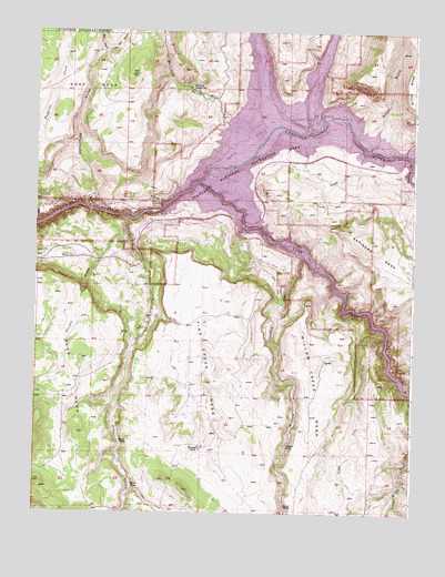
Sapinero, CO USGS Topographic Map
Click on map above to begin viewing in our Map Viewer.

This topographic map contains these locations and features:
Feature Name Type Latitude Longitude GNIS ID View Map
Blue Mesa DamDamN38.4532°W107.3343°188200View Map
Blue Mesa HeliportAirportN38.4497°W107.3345°204578View Map
Cottonwood GulchValleyN38.4541°W107.3568°188201View Map
Cow GulchValleyN38.3806°W107.2548°188194View Map
Curecanti National Recreation AreaParkN38.4678°W107.3240°196412View Map
Dillon GulchValleyN38.4737°W107.2628°186932View Map
Dry GulchValleyN38.4206°W107.2594°188193View Map
East Fork Dry GulchValleyN38.4056°W107.2688°188190View Map
Elizonde RanchLocaleN38.3917°W107.3203°188188View Map
Fourmile GulchValleyN38.4656°W107.2513°188203View Map
Lake ForkStreamN38.4605°W107.3220°188198View Map
Lake Fork CampgroundLocaleN38.4550°W107.3231°197505View Map
Little Mill GulchValleyN38.4940°W107.3529°186930View Map
McIntyre GulchValleyN38.4776°W107.3114°186931View Map
Mill GulchValleyN38.4939°W107.3534°186929View Map
Pine CreekStreamN38.4519°W107.3448°188191View Map
Pine Creek MesaSummitN38.4092°W107.3187°188189View Map
SapineroPopulated PlaceN38.4594°W107.3023°188204View Map
Sapinero DivisionCivilN38.3995°W107.2872°1935562View Map
Sapinero MesaSummitN38.4455°W107.2639°188197View Map
Sapinero Ranger StationLocaleN38.4855°W107.3248°188202View Map
Sheep CreekStreamN38.3817°W107.3428°188192View Map
Snelson CreekStreamN38.4455°W107.3442°188186View Map
Soap CreekStreamN38.4739°W107.2989°186639View Map
Swift CreekStreamN38.4442°W107.3023°189727View Map
West Elk CreekStreamN38.4742°W107.2859°186781View Map
Willow CreekStreamN38.4422°W107.2859°188196View Map

Note: Coordinates in the location and feature list above are referenced to NAD83 datum.


Copyright (C) 2008-2025 Ryan Niemi / Sunset Dynamics ... All Rights Reserved