TopoQuest Logo
Do you find TopoQuest useful?
Help keep TopoQuest running and adding new maps/features by donating!
Bitcoin:  19c7KJd3qBynnjoSw5npx9KScwjBe4ifkT
Litecoin:  LXs6TkuXGGXo1vDsWCkWVdjQX94eUKd6ui
Home View Maps Find Maps Find Places Resources & Links


Sawyerville, Alabama Topographic Map

USGS Map Title: Sawyerville, AL
USGS Map MRC: 32087G6
DRG (GeoTIFF) Download: o32087g6.tif


Neighboring USGS Topographic Map Quads:


  Knoxville, AL  
32087H7
 

  Moundville West, AL  
32087H6
 

  Moundville East, AL  
32087H5
 

  Warrior Dam, AL  
32087G7
 

  Sawyerville, AL  
32087G6
 

  Ingram, AL  
32087G5
 

  Mason Bend, AL  
32087F7
 

  Melton, AL  
32087F6
 

  Greensboro, AL  
32087F5


Map MRC Location:

N33°
W88°
N33°
W87°
H8 H7 H6 H5 H4 H3 H2 H1
G8 G7 G6 G5 G4 G3 G2 G1
F8 F7 F6 F5 F4 F3 F2 F1
E8 E7 E6 E5 E4 E3 E2 E1
D8 D7 D6 D5 D4 D3 D2 D1
C8 C7 C6 C5 C4 C3 C2 C1
B8 B7 B6 B5 B4 B3 B2 B1
A8 A7 A6 A5 A4 A3 A2 A1
N32°
W88°
N32°
W87°

Sawyerville, AL USGS 1:24K Topographic Map Preview:
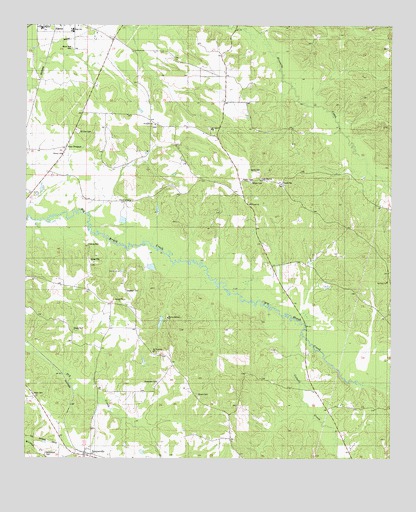
Sawyerville, AL USGS Topographic Map
Click on map above to begin viewing in our Map Viewer.

This topographic map contains these locations and features:
Feature Name Type Latitude Longitude GNIS ID View Map
Akron Community SchoolSchoolN32.8743°W87.7450°149277View Map
Akron High SchoolSchoolN32.8735°W87.7339°138941View Map
Akron New CemeteryCemeteryN32.8684°W87.7342°158771View Map
Baptist Retreat ChurchChurchN32.7907°W87.7020°113454View Map
Bethlehem CemeteryCemeteryN32.7516°W87.7425°114113View Map
Chalaybeate SpringSpringN32.8651°W87.6531°138961View Map
Church of GodChurchN32.8246°W87.7150°116137View Map
Colwell CreekStreamN32.7862°W87.6558°116465View Map
Ellis School (historical)SchoolN32.7871°W87.7208°138972View Map
Elwood ChurchChurchN32.8235°W87.6745°117970View Map
Elwood School (historical)SchoolN32.8235°W87.6731°138973View Map
Estes School (historical)SchoolN32.7640°W87.6347°138976View Map
Far View Plantation (historical)LocaleN32.8057°W87.6575°138978View Map
Five Mile CemeteryCemeteryN32.8461°W87.7060°158563View Map
Five Mile Church (historical)ChurchN32.8312°W87.6783°138981View Map
Fivemile ChurchChurchN32.8465°W87.7070°118343View Map
Greene Springs Academy (historical)SchoolN32.8651°W87.6556°138984View Map
Hale CountyCivilN32.7627°W87.6291°161558View Map
Harris CemeteryCemeteryN32.8334°W87.6735°119792View Map
Hill Zion ChurchChurchN32.8012°W87.6264°120112View Map
Hill Zion ChurchChurchN32.8312°W87.6703°120113View Map
Hobson School (historical)SchoolN32.7668°W87.6889°138997View Map
Langham CemeteryCemeteryN32.7986°W87.7156°121384View Map
Long CemeteryCemeteryN32.8675°W87.6848°149468View Map
Mays CemeteryCemeteryN32.7687°W87.7470°158866View Map
McCrarys BranchStreamN32.8471°W87.6450°161939View Map
Mount Hebron CemeteryCemeteryN32.8453°W87.6875°158577View Map
Mount Hebron ChurchChurchN32.8451°W87.6883°152422View Map
Mount Zion CemeteryCemeteryN32.8446°W87.7322°123426View Map
Mount Zion Church (historical)ChurchN32.8446°W87.7333°139027View Map
New ProspectPopulated PlaceN32.8399°W87.7364°123877View Map
Rams FieldParkN32.8728°W87.7342°2356931View Map
Rhone CemeteryCemeteryN32.7687°W87.6911°125588View Map
Robertson CemeteryCemeteryN32.7719°W87.7046°125706View Map
Saint Stephens ChurchChurchN32.7810°W87.7067°126213View Map
SawyervillePopulated PlaceN32.7518°W87.7295°155236View Map
Sawyerville Post OfficePost OfficeN32.7513°W87.7293°168613View Map
Sawyerville Volunteer Fire DepartmentBuildingN32.7511°W87.7295°2691383View Map
Stewart-Akron DivisionCivilN32.8645°W87.7010°165796View Map
Strickland/Smalley FieldAirportN32.8476°W87.7146°2679015View Map
Tanglewood University of Alabama Biological StationLocaleN32.8535°W87.6720°139069View Map
Wesley ChurchChurchN32.8379°W87.7383°128747View Map
Williams CemeteryCemeteryN32.8562°W87.6769°149476View Map
Wilson CemeteryCemeteryN32.8298°W87.6733°129071View Map

Note: Coordinates in the location and feature list above are referenced to NAD83 datum.


Copyright (C) 2008-2024 Ryan Niemi / Sunset Dynamics ... All Rights Reserved