TopoQuest Logo
Do you find TopoQuest useful?
Help keep TopoQuest running and adding new maps/features by donating!
Bitcoin:  19c7KJd3qBynnjoSw5npx9KScwjBe4ifkT
Litecoin:  LXs6TkuXGGXo1vDsWCkWVdjQX94eUKd6ui
Home View Maps Find Maps Find Places Resources & Links


Moundville East, Alabama Topographic Map

USGS Map Title: Moundville East, AL
USGS Map MRC: 32087H5
DRG (GeoTIFF) Download: o32087h5.tif


Neighboring USGS Topographic Map Quads:


  Fosters, AL  
33087A6
 

  Englewood, AL  
33087A5
 

  Duncanville, AL  
33087A4
 

  Moundville West, AL  
32087H6
 

  Moundville East, AL  
32087H5
 

  Payne Lake, AL  
32087H4
 

  Sawyerville, AL  
32087G6
 

  Ingram, AL  
32087G5
 

  Hogglesville, AL  
32087G4


Map MRC Location:

N33°
W88°
N33°
W87°
H8 H7 H6 H5 H4 H3 H2 H1
G8 G7 G6 G5 G4 G3 G2 G1
F8 F7 F6 F5 F4 F3 F2 F1
E8 E7 E6 E5 E4 E3 E2 E1
D8 D7 D6 D5 D4 D3 D2 D1
C8 C7 C6 C5 C4 C3 C2 C1
B8 B7 B6 B5 B4 B3 B2 B1
A8 A7 A6 A5 A4 A3 A2 A1
N32°
W88°
N32°
W87°

Moundville East, AL USGS 1:24K Topographic Map Preview:
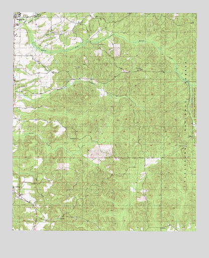
Moundville East, AL USGS Topographic Map
Click on map above to begin viewing in our Map Viewer.

This topographic map contains these locations and features:
Feature Name Type Latitude Longitude GNIS ID View Map
Camp Ground School (historical)SchoolN32.8815°W87.6020°161917View Map
Carthage ChurchChurchN32.9985°W87.6220°162893View Map
Carthage Presbyterian Church CemeteryCemeteryN32.9984°W87.6214°158559View Map
China Grove CemeteryCemeteryN32.9232°W87.5078°158561View Map
China Grove ChurchChurchN32.9243°W87.5075°159393View Map
Church of ChristChurchN32.9990°W87.6236°161919View Map
Elliot Creek School (historical)SchoolN32.9548°W87.5083°161922View Map
Fairview ChurchChurchN32.9821°W87.5675°159587View Map
Fairview School (historical)SchoolN32.9818°W87.5672°161924View Map
Green Springs School (historical)SchoolN32.8982°W87.6245°163439View Map
Greenleaf CemeteryCemeteryN32.9276°W87.5817°159695View Map
Greenleaf School (historical)SchoolN32.9273°W87.5808°161928View Map
Hale County High SchoolSchoolN32.9987°W87.6208°161929View Map
Harris CemeteryCemeteryN32.8821°W87.5928°161930View Map
HavanaPopulated PlaceN32.8951°W87.6203°159736View Map
Havana ChurchChurchN32.8965°W87.6245°161932View Map
Kings School (historical)SchoolN32.9601°W87.5653°161933View Map
Lewis CemeteryCemeteryN32.9935°W87.5819°162926View Map
Lewis ChurchChurchN32.9954°W87.5592°161935View Map
Lewis School (historical)SchoolN32.9951°W87.5611°161936View Map
Liberty CemeteryCemeteryN32.8762°W87.5239°158571View Map
Liberty ChurchChurchN32.8768°W87.5239°159931View Map
Moundville DivisionCivilN32.9463°W87.5556°165791View Map
Moundville United Methodist ChurchChurchN32.9971°W87.6247°161940View Map
Oak Hill CemeteryCemeteryN32.9932°W87.6219°160274View Map
Patten ChapelChurchN32.9607°W87.6245°161945View Map
PhippsPopulated PlaceN32.9296°W87.5028°160371View Map
Pleasant Hill CemeteryCemeteryN32.9673°W87.5392°158588View Map
Pleasant Hill Methodist ChurchChurchN32.9676°W87.5383°160408View Map
Salem ChurchChurchN32.9979°W87.5695°160551View Map
Star of Bethlehem CemeteryCemeteryN32.8988°W87.6250°160669View Map
Stewart - Havana Volunteer Fire Department Station 1BuildingN32.8951°W87.6201°2691511View Map
Tubbs School (historical)SchoolN32.9976°W87.5767°161960View Map
Wiggins BranchStreamN32.9937°W87.6172°160841View Map
Woods CemeteryCemeteryN32.9658°W87.5967°161964View Map

Note: Coordinates in the location and feature list above are referenced to NAD83 datum.


Copyright (C) 2008-2025 Ryan Niemi / Sunset Dynamics ... All Rights Reserved