TopoQuest Logo
Do you find TopoQuest useful?
Help keep TopoQuest running and adding new maps/features by donating!
Bitcoin:  19c7KJd3qBynnjoSw5npx9KScwjBe4ifkT
Litecoin:  LXs6TkuXGGXo1vDsWCkWVdjQX94eUKd6ui
Home View Maps Find Maps Find Places Resources & Links


Schott Mountain, Texas Topographic Map

USGS Map Title: Schott Mountain, TX
USGS Map MRC: 34101E1
DRG (GeoTIFF) Download: o34101e1.tif


Neighboring USGS Topographic Map Quads:


  Hardscrabble Creek, TX  
34101F2
 

  Willow Arroyo, TX  
34101F1
 

  Brice, TX  
34100F8
 

  Indian Peak, TX  
34101E2
 

  Schott Mountain, TX  
34101E1
 

  Hughes Canyon, TX  
34100E8
 

  Hay Lake, TX  
34101D2
 

  Lake Theo, TX  
34101D1
 

  Turkey, TX  
34100D8


Map MRC Location:

N35°
W102°
N35°
W101°
H8 H7 H6 H5 H4 H3 H2 H1
G8 G7 G6 G5 G4 G3 G2 G1
F8 F7 F6 F5 F4 F3 F2 F1
E8 E7 E6 E5 E4 E3 E2 E1
D8 D7 D6 D5 D4 D3 D2 D1
C8 C7 C6 C5 C4 C3 C2 C1
B8 B7 B6 B5 B4 B3 B2 B1
A8 A7 A6 A5 A4 A3 A2 A1
N34°
W102°
N34°
W101°

Schott Mountain, TX USGS 1:24K Topographic Map Preview:
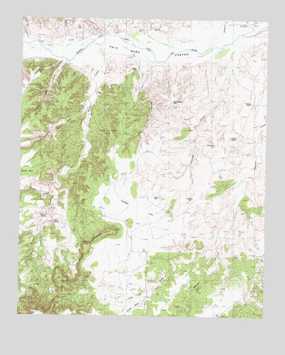
Schott Mountain, TX USGS Topographic Map
Click on map above to begin viewing in our Map Viewer.

This topographic map contains these locations and features:
Feature Name Type Latitude Longitude GNIS ID View Map
Barrel CreekStreamN34.6148°W101.0824°1372399View Map
Barrel TankReservoirN34.6039°W101.0669°1889908View Map
Bass TankReservoirN34.5501°W101.0544°1889913View Map
Caliche TankReservoirN34.5753°W101.0180°1889911View Map
Cherokee CampLocaleN34.5453°W101.0510°1354345View Map
Cherokee CreekStreamN34.6189°W101.0074°1354346View Map
Cleveland DrawValleyN34.5886°W101.0932°1354658View Map
Folley CanyonValleyN34.5512°W101.1080°1357531View Map
Gravel TankReservoirN34.5900°W101.0086°1889910View Map
Hackberry CreekStreamN34.6212°W101.0199°1358579View Map
Heckman CampLocaleN34.6242°W101.0438°1358991View Map
Horseshoe TankReservoirN34.5720°W101.0266°1890014View Map
Karnes FlatFlatN34.5467°W101.0707°1360494View Map
Little Indian CreekStreamN34.6101°W101.1015°1361386View Map
Long DrawValleyN34.5247°W101.0375°1361724View Map
Lost CanyonValleyN34.6071°W101.0556°1361813View Map
Lower Barrel CampLocaleN34.5465°W101.0854°1361899View Map
Marshall CreekStreamN34.6142°W101.1024°1362201View Map
Minnow SpringSpringN34.5412°W101.1121°1362955View Map
Rincon SchoolSchoolN34.5109°W101.0601°1366480View Map
Rough CreekStreamN34.6153°W101.1215°1366914View Map
Schott MountainSummitN34.5273°W101.0918°1367853View Map
Schott RanchLocaleN34.5209°W101.0643°1367854View Map
Scraper TankReservoirN34.5496°W101.0401°1889912View Map
South DrawValleyN34.5079°W101.0618°1376196View Map
Stinkhole WindmillLocaleN34.6181°W101.1032°1369213View Map
Terry SpringSpringN34.5390°W101.1085°1369746View Map
Wagon Wheel TankReservoirN34.5903°W101.0484°1889909View Map

Note: Coordinates in the location and feature list above are referenced to NAD83 datum.


Copyright (C) 2008-2025 Ryan Niemi / Sunset Dynamics ... All Rights Reserved