TopoQuest Logo
Do you find TopoQuest useful?
Help keep TopoQuest running and adding new maps/features by donating!
Bitcoin:  19c7KJd3qBynnjoSw5npx9KScwjBe4ifkT
Litecoin:  LXs6TkuXGGXo1vDsWCkWVdjQX94eUKd6ui
Home View Maps Find Maps Find Places Resources & Links


Lake Theo, Texas Topographic Map

USGS Map Title: Lake Theo, TX
USGS Map MRC: 34101D1
DRG (GeoTIFF) Download: o34101d1.tif


Neighboring USGS Topographic Map Quads:


  Indian Peak, TX  
34101E2
 

  Schott Mountain, TX  
34101E1
 

  Hughes Canyon, TX  
34100E8
 

  Hay Lake, TX  
34101D2
 

  Lake Theo, TX  
34101D1
 

  Turkey, TX  
34100D8
 

  Edgemon Lake, TX  
34101C2
 

  Quitaque, TX  
34101C1
 

  Folley, TX  
34100C8


Map MRC Location:

N35°
W102°
N35°
W101°
H8 H7 H6 H5 H4 H3 H2 H1
G8 G7 G6 G5 G4 G3 G2 G1
F8 F7 F6 F5 F4 F3 F2 F1
E8 E7 E6 E5 E4 E3 E2 E1
D8 D7 D6 D5 D4 D3 D2 D1
C8 C7 C6 C5 C4 C3 C2 C1
B8 B7 B6 B5 B4 B3 B2 B1
A8 A7 A6 A5 A4 A3 A2 A1
N34°
W102°
N34°
W101°

Lake Theo, TX USGS 1:24K Topographic Map Preview:
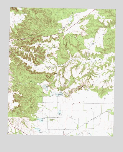
Lake Theo, TX USGS Topographic Map
Click on map above to begin viewing in our Map Viewer.

This topographic map contains these locations and features:
Feature Name Type Latitude Longitude GNIS ID View Map
Caprock Canyons State ParkParkN34.4437°W101.0521°2028658View Map
Caprock Canyons State Park and TrailwayTrailN34.4173°W101.0635°2032926View Map
Collier TankReservoirN34.3767°W101.0271°1859264View Map
Collier Tank DamDamN34.3767°W101.0271°1859263View Map
Dry CreekStreamN34.4167°W101.0735°1356305View Map
Dry Creek LakeReservoirN34.4148°W101.0749°1356341View Map
Eagles PointSummitN34.4359°W101.0718°1356553View Map
Gyp SpringsSpringN34.4451°W101.0832°1998646View Map
Hawkins LakeReservoirN34.4215°W101.0816°1358908View Map
Hawkins Lake DamDamN34.4201°W101.0788°1859253View Map
Holmes CreekStreamN34.4492°W101.0335°1359459View Map
John Haynes RidgeRidgeN34.4559°W101.1054°1360302View Map
Ladder TankReservoirN34.4659°W101.0288°1360824View Map
Lake TheoReservoirN34.4152°W101.0654°1369819View Map
Lake Theo DamDamN34.4167°W101.0621°1859251View Map
Luther LakeReservoirN34.4892°W101.0542°1859262View Map
Luther Lake DamDamN34.4901°W101.0538°1859261View Map
Natural BridgeArchN34.4362°W101.0652°2557032View Map
North Prong Little Red RiverStreamN34.4503°W101.0513°1364118View Map
Old Flat TopSummitN34.4026°W101.0993°1364419View Map
Quitaque DivisionCivilN34.4152°W101.0285°1939116View Map
Soil Conservation Service Site 1 DamDamN34.3917°W101.0838°1859257View Map
Soil Conservation Service Site 1 ReservoirReservoirN34.3917°W101.0838°1859258View Map
Soil Conservation Service Site 2 DamDamN34.3801°W101.0871°1859259View Map
Soil Conservation Service Site 2 ReservoirReservoirN34.3799°W101.0881°1859260View Map
Soil Conservation Service Site 3 DamDamN34.3967°W101.0638°1859255View Map
Soil Conservation Service Site 3 ReservoirReservoirN34.3967°W101.0638°1859256View Map
South Prong Little Red RiverStreamN34.4503°W101.0513°1376226View Map

Note: Coordinates in the location and feature list above are referenced to NAD83 datum.


Copyright (C) 2008-2025 Ryan Niemi / Sunset Dynamics ... All Rights Reserved