TopoQuest Logo
Do you find TopoQuest useful?
Help keep TopoQuest running and adding new maps/features by donating!
Bitcoin:  19c7KJd3qBynnjoSw5npx9KScwjBe4ifkT
Litecoin:  LXs6TkuXGGXo1vDsWCkWVdjQX94eUKd6ui
Home View Maps Find Maps Find Places Resources & Links


Sea Isle, Texas Topographic Map

USGS Map Title: Sea Isle, TX
USGS Map MRC: 29095B1
DRG (GeoTIFF) Download: o29095b1.tif


Neighboring USGS Topographic Map Quads:


  Mustang Bayou, TX  
29095C2
 

  Hitchcock, TX  
29095C1
 

  Virginia Point, TX  
29094C8
 

  Hoskins Mound, TX  
29095B2
 

  Sea Isle, TX  
29095B1
 

  Lake Como, TX  
29094B8
 

  Christmas Point, TX  
29095A2
 

  San Luis Pass, TX  
29095A1


Map MRC Location:

N30°
W96°
N30°
W95°
H8 H7 H6 H5 H4 H3 H2 H1
G8 G7 G6 G5 G4 G3 G2 G1
F8 F7 F6 F5 F4 F3 F2 F1
E8 E7 E6 E5 E4 E3 E2 E1
D8 D7 D6 D5 D4 D3 D2 D1
C8 C7 C6 C5 C4 C3 C2 C1
B8 B7 B6 B5 B4 B3 B2 B1
A8 A7 A6 A5 A4 A3 A2 A1
N29°
W96°
N29°
W95°

Sea Isle, TX USGS 1:24K Topographic Map Preview:
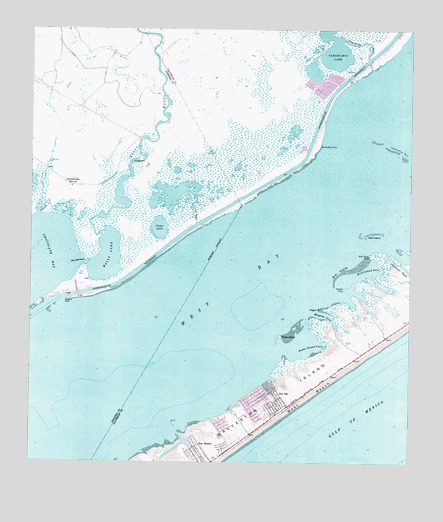
Sea Isle, TX USGS Topographic Map
Click on map above to begin viewing in our Map Viewer.

This topographic map contains these locations and features:
Feature Name Type Latitude Longitude GNIS ID View Map
Alligator PointCapeN29.1719°W95.1133°1381026View Map
Amarada CutBayN29.1986°W95.1210°1351065View Map
Bay HarborPopulated PlaceN29.1275°W95.0685°1351614View Map
Bird Island CoveBayN29.1808°W95.0116°1352225View Map
Bird IslandsIslandN29.1808°W95.0213°1352226View Map
Carancahua BayouStreamN29.2388°W95.0135°1353807View Map
Carancahua LakeLakeN29.2421°W95.0289°1353811View Map
Carancahua PointCapeN29.2166°W95.0305°1353813View Map
Cedar LakeLakeN29.1926°W95.0830°1381027View Map
Cow BayouGutN29.1969°W95.0716°1355190View Map
Galveston Fire Department Station 8BuildingN29.1421°W95.0452°2334329View Map
Halls BayouStreamN29.1919°W95.1008°1373982View Map
Halls LakeLakeN29.1847°W95.0991°1358682View Map
Maggies CoveBayN29.1680°W95.0277°1362069View Map
Maggies PointCapeN29.1697°W95.0294°1362070View Map
Marina at Sea IsleLocaleN29.1511°W95.0538°2030464View Map
McAllis PointCapeN29.1758°W95.0219°1362357View Map
Ostermayer BayouGutN29.1805°W95.0010°1364599View Map
Rattlesnake MoundSummitN29.2050°W95.1110°1366047View Map
Sea IslePopulated PlaceN29.1430°W95.0435°1367906View Map
Shell IslandIslandN29.1905°W95.0155°1368109View Map
Shell Island PointCapeN29.1850°W95.0130°1368110View Map
Snake IslandIslandN29.1616°W95.0430°1368548View Map
Snake Island CoveBayN29.1580°W95.0327°1368549View Map
Terramar BeachPopulated PlaceN29.1358°W95.0605°1381114View Map
The NarrowsChannelN29.1830°W95.1072°1369797View Map

Note: Coordinates in the location and feature list above are referenced to NAD83 datum.


Copyright (C) 2008-2025 Ryan Niemi / Sunset Dynamics ... All Rights Reserved