TopoQuest Logo
Do you find TopoQuest useful?
Help keep TopoQuest running and adding new maps/features by donating!
Bitcoin:  19c7KJd3qBynnjoSw5npx9KScwjBe4ifkT
Litecoin:  LXs6TkuXGGXo1vDsWCkWVdjQX94eUKd6ui
Home View Maps Find Maps Find Places Resources & Links


Christmas Point, Texas Topographic Map

USGS Map Title: Christmas Point, TX
USGS Map MRC: 29095A2
DRG (GeoTIFF) Download: o29095a2.tif


Neighboring USGS Topographic Map Quads:


  Danbury, TX  
29095B3
 

  Hoskins Mound, TX  
29095B2
 

  Sea Isle, TX  
29095B1
 

  Oyster Creek, TX  
29095A3
 

  Christmas Point, TX  
29095A2
 

  San Luis Pass, TX  
29095A1
 

  Freeport, TX  
28095H3


Map MRC Location:

N30°
W96°
N30°
W95°
H8 H7 H6 H5 H4 H3 H2 H1
G8 G7 G6 G5 G4 G3 G2 G1
F8 F7 F6 F5 F4 F3 F2 F1
E8 E7 E6 E5 E4 E3 E2 E1
D8 D7 D6 D5 D4 D3 D2 D1
C8 C7 C6 C5 C4 C3 C2 C1
B8 B7 B6 B5 B4 B3 B2 B1
A8 A7 A6 A5 A4 A3 A2 A1
N29°
W96°
N29°
W95°

Christmas Point, TX USGS 1:24K Topographic Map Preview:
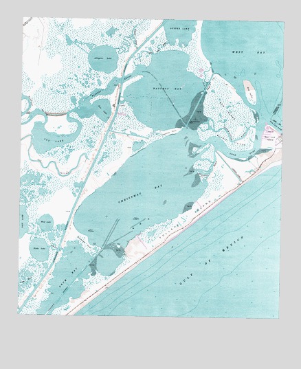
Christmas Point, TX USGS Topographic Map
Click on map above to begin viewing in our Map Viewer.

This topographic map contains these locations and features:
Feature Name Type Latitude Longitude GNIS ID View Map
Alligator LakeLakeN29.1085°W95.2118°1351019View Map
Alligator SloughGutN29.1177°W95.1977°1351025View Map
Alvin Branch LibraryBuildingN29.0905°W95.2447°2015071View Map
Arcadia ReefBarN29.0294°W95.2049°1351236View Map
Bastrop BayBayN29.0964°W95.1777°1351581View Map
Bastrop BayouStreamN29.1027°W95.1935°1351582View Map
Big SloughStreamN29.0664°W95.2185°1352139View Map
Bird IslandIslandN29.0955°W95.1410°1352224View Map
Brazoria National Wildlife RefugeParkN29.1073°W95.2344°1383784View Map
Cedar CutChannelN29.0319°W95.1916°1384776View Map
Christmas BayBayN29.0533°W95.1888°1354478View Map
Christmas PointCapeN29.0791°W95.1741°1354479View Map
Christmas Point ReefBarN29.0827°W95.1697°1354480View Map
Churchill BayouChannelN29.0636°W95.1585°1373106View Map
Cold PassChannelN29.0694°W95.1424°1354746View Map
Cox LakeLakeN29.0752°W95.2354°1355255View Map
Drum BayBayN29.0161°W95.2263°1356268View Map
Follets IslandIslandN29.0425°W95.1697°1357529View Map
Lost LakeLakeN29.0870°W95.2113°1361827View Map
Moodys IslandIslandN29.0733°W95.1497°1363085View Map
Mud CutGutN29.0983°W95.1610°1372860View Map
Mud IslandIslandN29.0880°W95.1524°1363406View Map
Nicks CutChannelN29.0275°W95.2338°1375126View Map
Nicks LakeLakeN29.0275°W95.2403°1363884View Map
Oyster LakeLakeN29.1227°W95.1749°1375322View Map
Oyster Lake BayouGutN29.1136°W95.1835°1364662View Map
Port MorrisPopulated PlaceN29.0966°W95.2038°1381110View Map
Rattlesnake PointCapeN29.0300°W95.2180°1366051View Map
San Luis IslandIslandN29.0750°W95.1280°1367525View Map
Titlum-Tatlum BayouChannelN29.0752°W95.1469°1376468View Map
Wolf LakeLakeN29.0388°W95.2373°1371860View Map

Note: Coordinates in the location and feature list above are referenced to NAD83 datum.


Copyright (C) 2008-2025 Ryan Niemi / Sunset Dynamics ... All Rights Reserved