TopoQuest Logo
Do you find TopoQuest useful?
Help keep TopoQuest running and adding new maps/features by donating!
Bitcoin:  19c7KJd3qBynnjoSw5npx9KScwjBe4ifkT
Litecoin:  LXs6TkuXGGXo1vDsWCkWVdjQX94eUKd6ui
Home View Maps Find Maps Find Places Resources & Links


Seabeck, Washington Topographic Map

USGS Map Title: Seabeck, WA
USGS Map MRC: 47122F7
DRG (GeoTIFF) Download: o47122f7.tif


Neighboring USGS Topographic Map Quads:


  Mount Walker, WA  
47122G8
 

  Quilcene, WA  
47122G7
 

  Lofall, WA  
47122G6
 

  Brinnon, WA  
47122F8
 

  Seabeck, WA  
47122F7
 

  Poulsbo, WA  
47122F6
 

  Holly, WA  
47122E8
 

  Wildcat Lake, WA  
47122E7
 

  Bremerton West, WA  
47122E6


Map MRC Location:

N48°
W123°
N48°
W122°
H8 H7 H6 H5 H4 H3 H2 H1
G8 G7 G6 G5 G4 G3 G2 G1
F8 F7 F6 F5 F4 F3 F2 F1
E8 E7 E6 E5 E4 E3 E2 E1
D8 D7 D6 D5 D4 D3 D2 D1
C8 C7 C6 C5 C4 C3 C2 C1
B8 B7 B6 B5 B4 B3 B2 B1
A8 A7 A6 A5 A4 A3 A2 A1
N47°
W123°
N47°
W122°

Seabeck, WA USGS 1:24K Topographic Map Preview:
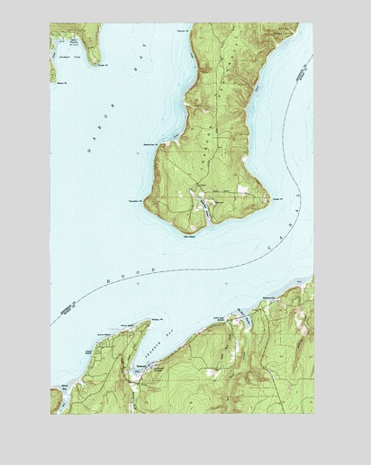
Seabeck, WA USGS Topographic Map
Click on map above to begin viewing in our Map Viewer.

This topographic map contains these locations and features:
Feature Name Type Latitude Longitude GNIS ID View Map
Anderson CreekStreamN47.6654°W122.7577°1515865View Map
Big Beef CreekStreamN47.6520°W122.7832°1516465View Map
Big Beef HarborBayN47.6554°W122.7840°1516466View Map
Camp ParsonsLocaleN47.7456°W122.8649°1517300View Map
Central Kitsap Fire and Rescue Station 53 SeabeckBuildingN47.6375°W122.8320°2643818View Map
Conference GroundsLocaleN47.6398°W122.8274°1518013View Map
CoylePopulated PlaceN47.6979°W122.8054°1518239View Map
Fisherman HarborBayN47.6901°W122.8018°1519613View Map
Hazel PointCapeN47.6931°W122.7710°1520642View Map
Hood CanalBayN47.6570°W122.8573°1520890View Map
Jackson CoveBayN47.7401°W122.8679°1521308View Map
Jefferson County Fire District 2 Quilcene Fire Rescue Station 22BuildingN47.7094°W122.7965°2643491View Map
Klahowya Secondary SchoolSchoolN47.6288°W122.7540°2605867View Map
Lawters BeachPopulated PlaceN47.6590°W122.7782°1531664View Map
Little Beef CreekStreamN47.6543°W122.7929°1522159View Map
Little Beef HarborBayN47.6551°W122.7952°1522160View Map
Lone RockPillarN47.6645°W122.7604°1528864View Map
Lone Rock ChapelChurchN47.6577°W122.7756°2609316View Map
Maple BeachBeachN47.6445°W122.8563°1522684View Map
Miami BeachBeachN47.6520°W122.8382°1523042View Map
Misery PointCapeN47.6543°W122.8288°1523268View Map
Oak HeadCapeN47.6829°W122.8099°1523952View Map
Pulali PointCapeN47.7365°W122.8540°1524685View Map
Scenic BeachBeachN47.6501°W122.8471°1525487View Map
Scenic Beach State ParkParkN47.6498°W122.8457°1531640View Map
SeabeckPopulated PlaceN47.6395°W122.8285°1525535View Map
Seabeck BayBayN47.6462°W122.8277°1525536View Map
Seabeck Census Designated PlaceCensusN47.6442°W122.8228°2585034View Map
Seabeck CreekStreamN47.6368°W122.8354°1525537View Map
Seabeck Elementary SchoolSchoolN47.6520°W122.8379°1530737View Map
Seabeck MarinaLocaleN47.6415°W122.8296°2610293View Map
Stavis BayBayN47.6334°W122.8690°1526512View Map
Tabook PointCapeN47.7473°W122.8090°1526888View Map
Tskutsko PointCapeN47.6929°W122.8318°1527424View Map
WarrenvillePopulated PlaceN47.6604°W122.7707°1527815View Map
Wawa PointCapeN47.7306°W122.8735°1527860View Map
Zelatched PointCapeN47.7109°W122.8240°1528374View Map

Note: Coordinates in the location and feature list above are referenced to NAD83 datum.


Copyright (C) 2008-2024 Ryan Niemi / Sunset Dynamics ... All Rights Reserved