TopoQuest Logo
Do you find TopoQuest useful?
Help keep TopoQuest running and adding new maps/features by donating!
Bitcoin:  19c7KJd3qBynnjoSw5npx9KScwjBe4ifkT
Litecoin:  LXs6TkuXGGXo1vDsWCkWVdjQX94eUKd6ui
Home View Maps Find Maps Find Places Resources & Links


Wildcat Lake, Washington Topographic Map

USGS Map Title: Wildcat Lake, WA
USGS Map MRC: 47122E7
DRG (GeoTIFF) Download: o47122e7.tif


Neighboring USGS Topographic Map Quads:


  Brinnon, WA  
47122F8
 

  Seabeck, WA  
47122F7
 

  Poulsbo, WA  
47122F6
 

  Holly, WA  
47122E8
 

  Wildcat Lake, WA  
47122E7
 

  Bremerton West, WA  
47122E6
 

  Lake Wooten, WA  
47122D8
 

  Belfair, WA  
47122D7
 

  Burley, WA  
47122D6


Map MRC Location:

N48°
W123°
N48°
W122°
H8 H7 H6 H5 H4 H3 H2 H1
G8 G7 G6 G5 G4 G3 G2 G1
F8 F7 F6 F5 F4 F3 F2 F1
E8 E7 E6 E5 E4 E3 E2 E1
D8 D7 D6 D5 D4 D3 D2 D1
C8 C7 C6 C5 C4 C3 C2 C1
B8 B7 B6 B5 B4 B3 B2 B1
A8 A7 A6 A5 A4 A3 A2 A1
N47°
W123°
N47°
W122°

Wildcat Lake, WA USGS 1:24K Topographic Map Preview:
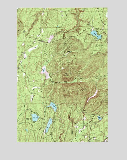
Wildcat Lake, WA USGS Topographic Map
Click on map above to begin viewing in our Map Viewer.

This topographic map contains these locations and features:
Feature Name Type Latitude Longitude GNIS ID View Map
Alpine Evergreen QuarryMineN47.5068°W122.7639°2605729View Map
Barney White RanchLocaleN47.5056°W122.7832°1516152View Map
BelfairLocaleN47.5023°W122.7774°1516382View Map
Bremerton DivisionCivilN47.5938°W122.7880°1939456View Map
Camp UnionLocaleN47.5931°W122.8404°1517318View Map
Casad DamDamN47.5381°W122.7796°1532145View Map
Central Kitsap Fire and Rescue Station 55 - Lake TahuyehBuildingN47.5675°W122.8424°2643814View Map
Central Kitsap Fire and Rescue Station 56 Seabeck / NicholasBuildingN47.6217°W122.7627°2643496View Map
Central Kitsap Fire and Rescue Station 65 - Wildcat LakeBuildingN47.6052°W122.7741°2643813View Map
Christian Worship CenterChurchN47.5937°W122.8405°2609824View Map
CrosbyPopulated PlaceN47.5820°W122.8660°1518342View Map
Crosby ChapelChurchN47.5824°W122.8669°2609825View Map
East Fork Union RiverStreamN47.5040°W122.7935°1519132View Map
Evergreen Lutheran ChurchChurchN47.5936°W122.8509°2609826View Map
Evergreen Lutheran PreschoolSchoolN47.5936°W122.8509°2606483View Map
Gold CreekStreamN47.5595°W122.8329°1520079View Map
Gold MountainSummitN47.5487°W122.7860°1520105View Map
Gold Mountain Golf ClubLocaleN47.5184°W122.7514°2608399View Map
Gold Mountain LookoutLocaleN47.5490°W122.7868°1530129View Map
Great PeninsulaCapeN47.5498°W122.8179°1529158View Map
Green MountainSummitN47.5634°W122.8068°1520307View Map
Green Mountain Elementary SchoolSchoolN47.5986°W122.8198°2606494View Map
Green Mountain LookoutLocaleN47.5631°W122.8074°1530131View Map
Hazel CreekStreamN47.5148°W122.7899°1520640View Map
Hite CenterPopulated PlaceN47.6018°W122.8640°1520824View Map
KCPQ-TV (Tacoma)TowerN47.5479°W122.8074°1534556View Map
KTBW-TV (Tacoma)TowerN47.5470°W122.7954°1534555View Map
Lake William SymingtonReservoirN47.5960°W122.8300°1528166View Map
Leisureland AirparkAirportN47.6075°W122.7744°1533693View Map
Lewis DamDamN47.5665°W122.8646°1532170View Map
McCaslin MarshSwampN47.5420°W122.8548°1522859View Map
McKenna FallsFallsN47.5276°W122.7862°1522909View Map
Mission LakeLakeN47.5331°W122.8266°1523274View Map
North Mason Regional Fire Authority Station 24BuildingN47.5176°W122.8379°2643851View Map
Olympic View Industrial ParkLocaleN47.5012°W122.7643°1530204View Map
Olympic View Landfill Leachate LagoonLocaleN47.5001°W122.7896°2610641View Map
Olympic View Sanitary LandfillLocaleN47.5016°W122.7824°2605579View Map
Panther CreekStreamN47.5290°W122.8657°1524169View Map
Panther LakeLakeN47.5227°W122.8516°1524178View Map
Port of Bremerton QuarryMineN47.5037°W122.7706°2605731View Map
Seabeck Post OfficePost OfficeN47.6064°W122.8446°2607015View Map
Seven Beavers QuarryMineN47.5672°W122.8660°2605749View Map
Sprague PondLakeN47.6074°W122.8199°1530259View Map
Stavis CreekStreamN47.6248°W122.8715°1526513View Map
Tahuya LakeSwampN47.5669°W122.8369°1532169View Map
Tahuya River DamDamN47.5581°W122.8363°1532168View Map
Tiger LakeLakeN47.5159°W122.8324°1527213View Map
Tin Mine CreekStreamN47.5706°W122.8376°1527245View Map
Tin Mine LakeSwampN47.5825°W122.8061°1527246View Map
Twin LakesLakeN47.5219°W122.7628°1527539View Map
Union River ReservoirReservoirN47.5432°W122.7714°1532146View Map
Wildcat AcresLocaleN47.6090°W122.7660°1530451View Map
Wildcat LakeLakeN47.5996°W122.7673°1528139View Map
Wildcat LakePopulated PlaceN47.6045°W122.7668°1528140View Map
Wildcat QuarryMineN47.5939°W122.7913°2605618View Map
William Symington DamDamN47.5981°W122.8263°1532171View Map

Note: Coordinates in the location and feature list above are referenced to NAD83 datum.


Copyright (C) 2008-2024 Ryan Niemi / Sunset Dynamics ... All Rights Reserved