TopoQuest Logo
Do you find TopoQuest useful?
Help keep TopoQuest running and adding new maps/features by donating!
Bitcoin:  19c7KJd3qBynnjoSw5npx9KScwjBe4ifkT
Litecoin:  LXs6TkuXGGXo1vDsWCkWVdjQX94eUKd6ui
Home View Maps Find Maps Find Places Resources & Links


Seaton, Illinois Topographic Map

USGS Map Title: Seaton, IL
USGS Map MRC: 41090A7
DRG (GeoTIFF) Download: o41090a7.tif


Neighboring USGS Topographic Map Quads:


  Joy, IL  
41090B8
 

  Aledo West, IL  
41090B7
 

  Aledo East, IL  
41090B6
 

  Keithsburg, IL  
41090A8
 

  Seaton, IL  
41090A7
 

  Little York, IL  
41090A6
 

  Oquawka, IL  
40090H8
 

  Rozetta, IL  
40090H7
 

  Monmouth, IL  
40090H6


Map MRC Location:

N42°
W91°
N42°
W90°
H8 H7 H6 H5 H4 H3 H2 H1
G8 G7 G6 G5 G4 G3 G2 G1
F8 F7 F6 F5 F4 F3 F2 F1
E8 E7 E6 E5 E4 E3 E2 E1
D8 D7 D6 D5 D4 D3 D2 D1
C8 C7 C6 C5 C4 C3 C2 C1
B8 B7 B6 B5 B4 B3 B2 B1
A8 A7 A6 A5 A4 A3 A2 A1
N41°
W91°
N41°
W90°

Seaton, IL USGS 1:24K Topographic Map Preview:
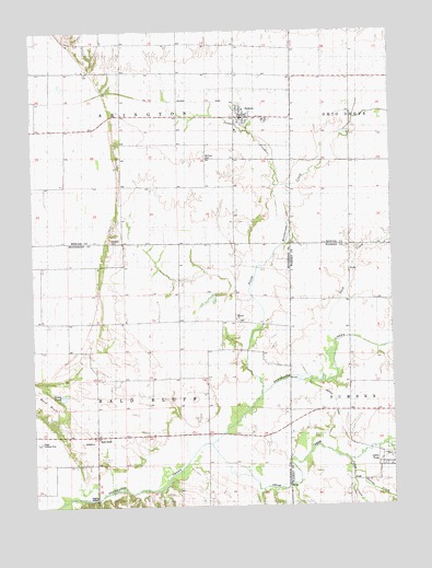
Seaton, IL USGS Topographic Map
Click on map above to begin viewing in our Map Viewer.

This topographic map contains these locations and features:
Feature Name Type Latitude Longitude GNIS ID View Map
Abington Center School (historical)SchoolN41.1214°W90.8335°403321View Map
Bald BluffPopulated PlaceN41.0186°W90.8538°422428View Map
Bald Bluff School (historical)SchoolN41.0231°W90.8538°403845View Map
Belmont CemeteryCemeteryN41.0486°W90.8035°1968240View Map
Belmont ChurchChurchN41.0492°W90.8043°1812515View Map
Belmont School (historical)SchoolN41.0481°W90.8046°404153View Map
Cedar CreekStreamN41.0167°W90.8146°405740View Map
Davids CreekStreamN41.0089°W90.7646°406964View Map
Douglas School (historical)SchoolN41.0561°W90.8732°407355View Map
Duck CreekStreamN41.0436°W90.7685°407451View Map
Goose PondLakeN41.0289°W90.8650°1720227View Map
Hawkins CemeteryCemeteryN41.0698°W90.8476°1720174View Map
Johns CreekStreamN41.0128°W90.7662°411141View Map
Kissinger LakeReservoirN41.0567°W90.8151°1691461View Map
Kissinger Lake DamDamN41.0567°W90.8151°1691460View Map
McClure CemeteryCemeteryN41.0925°W90.8146°413208View Map
Meyer Landing Strip (historical)AirportN41.0173°W90.8749°1720228View Map
North Henderson CreekStreamN41.0320°W90.7924°414618View Map
Scaly Point School (historical)SchoolN41.0906°W90.7632°418058View Map
SeatonPopulated PlaceN41.1023°W90.8015°418171View Map
Seaton Community Fire StationBuildingN41.1027°W90.8026°2640801View Map
Seaton Post OfficePost OfficeN41.1022°W90.8016°2788575View Map
Snake CreekStreamN41.0842°W90.7899°418668View Map
Township of AbingtonCivilN41.1132°W90.8420°428569View Map
Township of Bald BluffCivilN41.0293°W90.8555°428629View Map
Village of SeatonCivilN41.1023°W90.7991°2399779View Map
Walnut Grove School (historical)SchoolN41.1214°W90.8029°420470View Map

Note: Coordinates in the location and feature list above are referenced to NAD83 datum.


Copyright (C) 2008-2024 Ryan Niemi / Sunset Dynamics ... All Rights Reserved